
Key geological properties (datasets) that led to the selection of the site are summarised in Fig. 5‑1. The site lies in a tectonically quiet and stable area with limited deformation in the external northern Alpine foreland basin (Section 1.5 of NTB 24‑17, Nagra 2024i). It is located away from large-scale tectonic zones of increased geological complexity (Alps, Internal Jura, Upper Rhine Graben, Hegau – Bodensee Graben). The area is characterised by low seismic activity and low deformation and uplift rates. In the potential repository zone, the host rock (Opalinus Clay) occurs ~ 900 m below ground level in a flat-lying configuration with a thickness of around 105 m (Section 4.2.6 of NTB 24-17, Nagra 2024i). 3D seismic data indicate that the potential repository zone is in an area devoid of any seismically mappable faults (Section 4.3.4 of NTB 24-17, Nagra 2024i). Past deformation has essentially been accommodated in regional faults zones situated to the north and to the south. The same is also expected for tectonic deformation that could potentially occur during the time period for assessment (Section 6.6.2 in NTB 24-17, Nagra 2024i). The regional geological setting and the local host rock configuration thus provide stable geological conditions regarding long-term geological changes of the site. The size of the area without mappable signs of tectonic faults ensures flexibility with respect to the repository design.
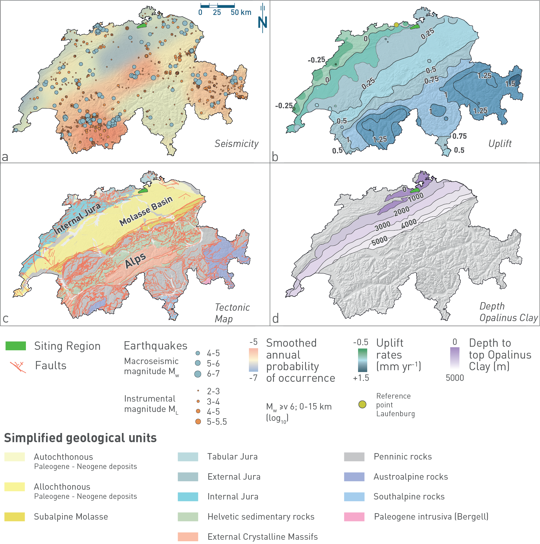
Fig. 5‑1:Key datasets used for selecting the site in Northern Switzerland
The site is characterised by low (a) seismic activity and (b) uplift rates. 3D seismic data indicate that the repository will be located in an area (c) devoid of any seismically mappable faults and (d) where the Opalinus Clay occurs ~ 900 m below ground level in a flat-lying configuration with a thickness of around 105 m.
Simplified from Fig. 1-3 in Chapter 1 of NTB 24-17 (Nagra 2024i).
The host rock, Opalinus Clay, consists of a ca. 174 Ma old, ca. 105 m thick and clay-mineral rich unit with very low hydraulic conductivity (Fig. 5‑2), embedded in low-permeability confining geological units (Section 4.2.6 and Chapter 5 in NTB 24-17, Nagra 2024i).
The aquitard sequence comprising the host rock and its low-permeability confining geological units, which is at least 300 m thick, is overlain by the regional Malm aquifer (Section 4.5.3 in NTB 24-17, Nagra 2024i). The ca. 40 m thick, clay-mineral-poor «Herrenwis Unit» is regarded as part of the low-permeability upper confining geological units, as the observed hydraulic conductivities are low, and the whole unit is embedded in clay-mineral-rich sequences. Observed low hydraulic heads indicate that the «Herrenwis Unit» is hydraulically isolated from the regional flow systems.
The Malm aquifer overlying the thick aquitard sequence is characterised by a fracture-dominated permeability, which mainly occurs in the upper part of the unit. Groundwater in the Malm aquifer contains a fossil marine component indicating rather stagnant flow conditions. This is confirmed, e.g., by compositions of stable isotopes of groundwater as illustrated in Fig. 5‑2 (Section 4.5.5 in NTB 24-17, Nagra 2024i)
The first potential aquifer below the aquitard sequence is the Keuper aquifer (Section 4.5.3 in NTB 24-17, Nagra 2024i) Regionally, this is a complex aquifer with potential water-conducting zones in different subunits. Next to the site, zones with increased hydraulic conductivities have only been observed in conjunction with localised fluvial deposits with increased porosity in two boreholes in the western part of the region (in the BAC1-1 and STA2-1 boreholes). The sampled groundwater is a mix of meteoric and higher saline water components (Section 4.5.5 in NTB 24-17, Nagra 2024i) As the transmissive fluvial deposits occur only locally, the Keuper aquifer is not regarded as an effective flow system and the underlying units can contribute at least locally to the transport barrier (Section 4.9 in NTB 24-17, Nagra 2024i) Due to the heterogeneous nature of water-conducting units, the uncertainty regarding the significance of the Keuper aquifer for advective transport remains comparably large.
The next aquifer of regional hydrogeological importance below the host rock is the Muschelkalk aquifer, a fractured aquifer including zones with increased porosity (see Section 4.5.3 in NTB 24-17, Nagra 2024i) The Muschelkalk aquifer hosts the most dynamic deep aquifer at the site. The groundwater is of cold-time meteoric origin (Section 4.5.5 in NTB 24-17, Nagra 2024i)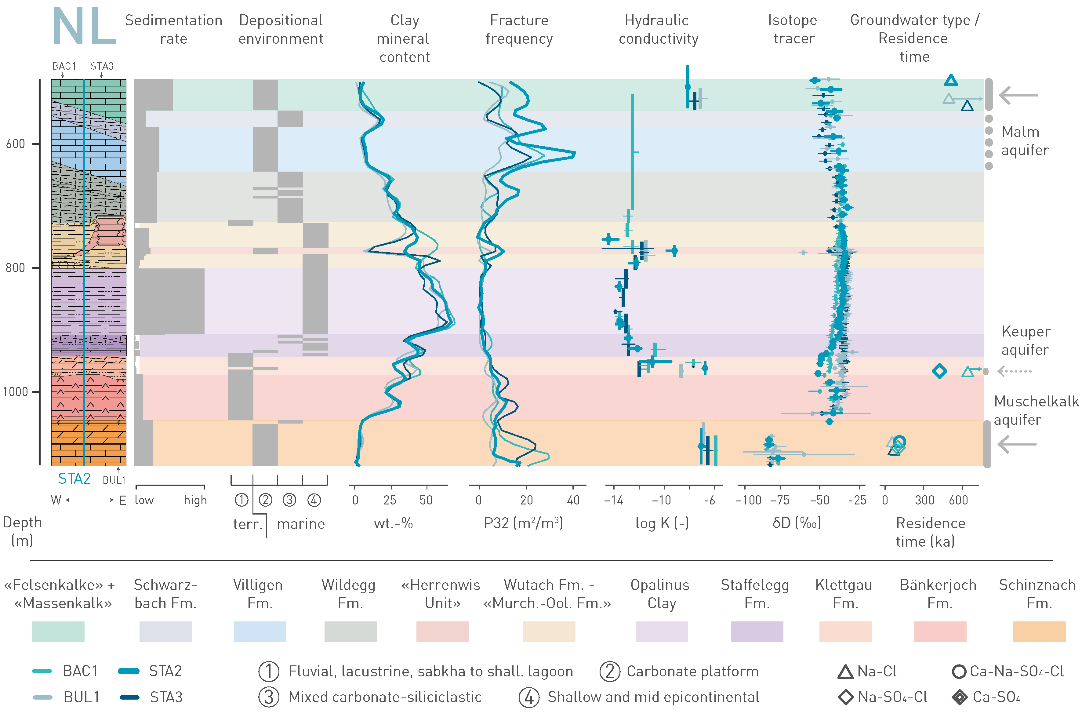
Fig. 5‑2:Synthesis of key observations of the rock sequence between the Muschelkalk and Malm aquifers at the site
Data from three deep boreholes, labelled BAC-1, BUL-1 and STA-3, are projected to the data of the reference borehole labelled STA-2. For further explanation of this figure, consult Section 4.9 in NTB 24-17 (Nagra 2024i). The figure shows that the low-permeability zone around the host rock is delimited in the vertical direction by the occurrence of aquifers. The profiles of the natural tracers in between the aquifers can be explained by diffusive transport. The regional Malm and Muschelkalk aquifers define the maximum extent of the low-permeability zone. In between, the locally occurring Keuper aquifer must also be considered.
The hydraulic head distribution within the CRZ is controlled by the difference of hydraulic heads and distribution of conductivities between aquifers above and below the Opalinus Clay. Hydraulic head measurements in the regional aquifer systems were carried out in deep boreholes. The hydraulic head was regionally assessed using a hydrogeological model (Section 4.5.4 in NTB 24-17, Nagra 2024i). By considering the distance between aquifers and the vertical distribution of hydraulic conductivities in the aquitards, the magnitude and direction of the vertical hydraulic gradient could be determined. As stated above, the Malm aquifer is the closest above the Opalinus Clay, with the Muschelkalk aquifer below and the Keuper aquifer potentially reducing the distance between aquifers.
Hydraulic head differences are small within the site. While the combination of the Malm and Muschelkalk aquifers shows overall downward gradients, the northern part of the site indicates weak upward gradients when the Keuper aquifer is considered.
The absolute magnitude of the hydraulic head difference is mainly below ca. 100 m within the site.
The host rock is characterised by a fine and homogeneous pore structures, a very low hydraulic conductivity and, consequently, diffusion-dominated solute transport and a high self-sealing capacity (Chapter 5 in NTB 24-17, Nagra 2024i). It has a homogeneous and high clay-mineral content giving it a high sorption capacity for many radionuclides. Moreover, the mineralogy allows for efficient porewater buffering, providing stable and reducing geochemical conditions. Its exceptionally low lateral and horizontal variability is due to a relatively uniform marine depositional environment characterised by high clay-mineral input and relatively high sedimentation rates (Section 3.3.2 of NTB 24-17, Nagra 2024i).
Any so-far undetected subseismic faults are not expected to represent distinct flow paths. This is primarily due to deformation in the Opalinus Clay, which is typically accommodated in a distributed manner with soft-linked segmented fault planes, making continuous flow paths unlikely (Section 5.10 in NTB 24-17, Nagra 2024i). Secondly, the low stiffness and the high swelling capacity of the clay-mineral-rich host rock results in efficient self-sealing of fractures. A clear relationship between high clay-mineral content and low hydraulic conductivity was confirmed by the analyses of numerous hydraulic packer tests carried out during the most recent field investigations (Fig. 5‑3).
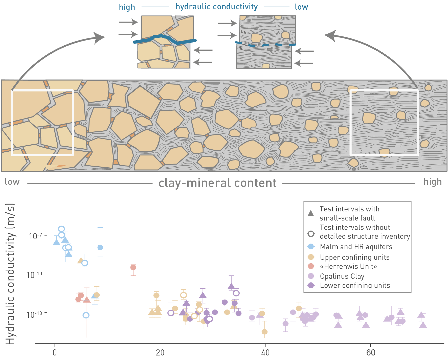
Fig. 5‑3:Link between texture and clay-mineral content and the hydraulic properties in Mesozoic sediments of Northern Switzerland (lower confining units to upper aquifers)
Note Opalinus Clay values with consistently high clay contents and very low hydraulic conductivities.
The uppermost figure depicts a highly simplified transition from a grain-supported framework (clastics or carbonate skeleton, with low clay-mineral content partially filling the pores) on the left side, to a clay-matrix-supported framework on the right. Transition to the clay-matrix-supported framework at approximately 20 to 40 wt.-% is consistent with the low hydraulic conductivities. Note: figure shows data from Liassic to Malm. For further explanation of this figure, consult Section 5.10 in NTB 24-17 (Nagra 2024i).
Independent evidence for the highly effective barrier function of the host rock and confining geological units over geological timescales and for diffusion-dominated transport is provided by natural tracer profiles of the porewater composition (see Section 9.1.1).