
3. Geological evolution of Northern Switzerland (NTB 24-17)
Key points:
- The Paleozoic basement of Northern Switzerland is characterised by ENE-WSW-trending Permo-Carboniferous troughs and NW-SE- and NNE-SSW-trending faults. These structures acted as zones of weakness localising subsequent strain.
- During the Mesozoic, Northern Switzerland was located in the subsiding Central European Basin where sedimentary deposition mostly took place in shallow marine epicontinental environments. The Opalinus Clay was deposited at around 174 Ma during
a phase of rapid subsidence and high clay-mineral input probably in combination with ocean currents favouring rapid sediment accumulation. - Miocene times in Northern Switzerland saw the northwest-ward propagation of the Alpine deformation front and the formation of the Jura Fold-and-Thrust Belt.
- During the Pliocene and Quaternary, uplift and drainage reorganisation resulted in river incision. Quaternary foreland glaciations led to the erosion and infill of overdeepened valleys and the deposition of thick fluvioglacial deposits.
This chapter provides an overview of the geological evolution of Northern Switzerland (Fig. 3‑1). It links the larger scale with the local conditions and processes that gave rise to the deposition, diagenesis and deformation of the rocks occurring in the study area. It aims to contextualise subsequent chapters, which will provide further details on the topics relevant for the characterisation of the geological barrier and its long-term evolution.
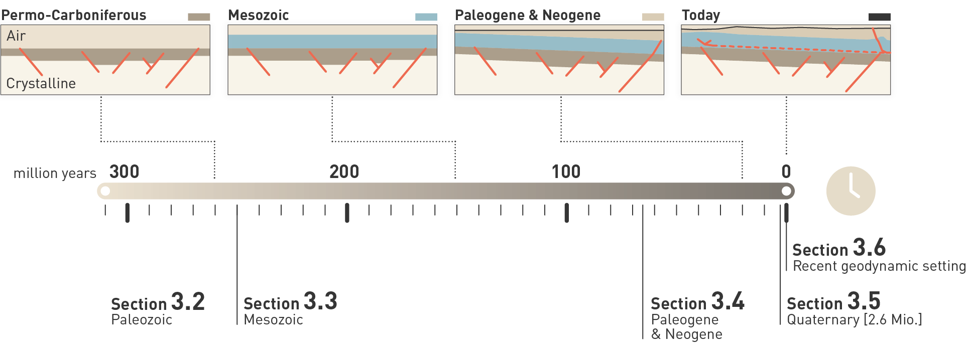
Fig. 3‑1:Visualisation of the structure of the chapter
Regional geological research over more than 100 years, complemented by site investigations (Chapter 2), provide a basis for reconstructing the geological evolution of Northern Switzerland and adjacent areas. The area considered in the present report is termed Northern Switzerland. It is bordered by the Black Forest Massif and the Tabular Jura in the north, the Hegau – Bodensee Graben in the northeast, the Upper Rhine Graben in the west, and the northern Swiss Molasse Basin in the south (Fig. 3‑2, Fig. 3‑3). In Northern Switzerland, the Mesozoic strata considered autochthonous are referred to as the Tabular Jura. The Jura Fold-and-Thrust Belt comprises External Jura and Internal Jura, where the Internal Jura is defined as the more strongly deformed part. A summary of the geological evolution of Northern Switzerland is presented in Fig. 3‑4.
The Black Forest Massif is composed mainly of crystalline rocks and is considered to be autochthonous. The Variscan orogeny, however, strongly deformed the crystalline basement of the Black Forest and adjacent Northern Switzerland, resulting in crustal-scale shear zones. Post-Variscan orogenic collapse and transtension resulted in the formation of the Konstanz – Frick Trough, which is a Permo-Carboniferous ENE-WSW-trending graben crossing Northern Switzerland. During the Permo-Carboniferous, coarse- to fine-grained siliciclastic sediments were deposited on alluvial plains under humid to arid conditions.
Towards the end of the Permian, the landscape was generally eroded to form a peneplain. In conjunction with renewed subsidence in the Triassic, Northern Switzerland lay within the southern part of the Central European Basin. Deposition during the Middle and Late Triassic was controlled by two major phases of transgression and regression preserved in the Muschelkalk and Keuper Groups respectively. Siliciclastic, evaporitic and carbonate sediments were deposited in terrestrial, coastal to marine depositional environments under subtropical to arid conditions.
During the Early and Middle Jurassic, mostly argillaceous and calcareous sediments (Lias and Dogger Groups) were deposited in a shallow epicontinental sea that formed during the opening of the Piemont – Liguria Ocean, part of the Neotethys. At this time, accommodation space was created by subsidence resulting from stretching and/or cooling of the lithosphere. During the Late Jurassic, mostly calcareous and marly sediments (Malm Group) were deposited in a shallow marine environment. The Mesozoic sequence outcrops in the Jura Fold-and-Thrust Belt. The Subalpine Molasse, the Swiss Molasse Basin and the Jura Fold-and-Thrust Belt together form the North Alpine Foreland. The Molasse Basin formed as flexural foreland basin. It comprises Paleogene and Neogene sedimentary rocks.
From the latest Mesozoic to the Oligocene, terrestrial conditions again prevailed in the region. Exhumation and a tropical climate led to intense weathering and erosion resulting in the top of the Malm Group being heavily karstified. Residual sediments (Siderolithic Group) of Eocene age can be found in palaeokarst depressions and infills.
North Alpine Foreland subsidence resulted in the Late Eocene in the deposition of the Lower Marine Molasse Group (UMM). In Northern Switzerland, terrestrial sedimentation resumed during the Late Oligocene with deposition of medium- to fine-grained siliciclastic sediments on large debris fan systems (Lower Freshwater Molasse Group, USM). Note that the classical German abbreviations for the Molasse deposits are used (Fig. 3‑4; Matter 1980). During late Early Miocene times, the latest transgression to affect Northern Switzerland led to deposition of sandstone and marl in shallow marine and coastal environments (Upper Marine Molasse Group, OMM).
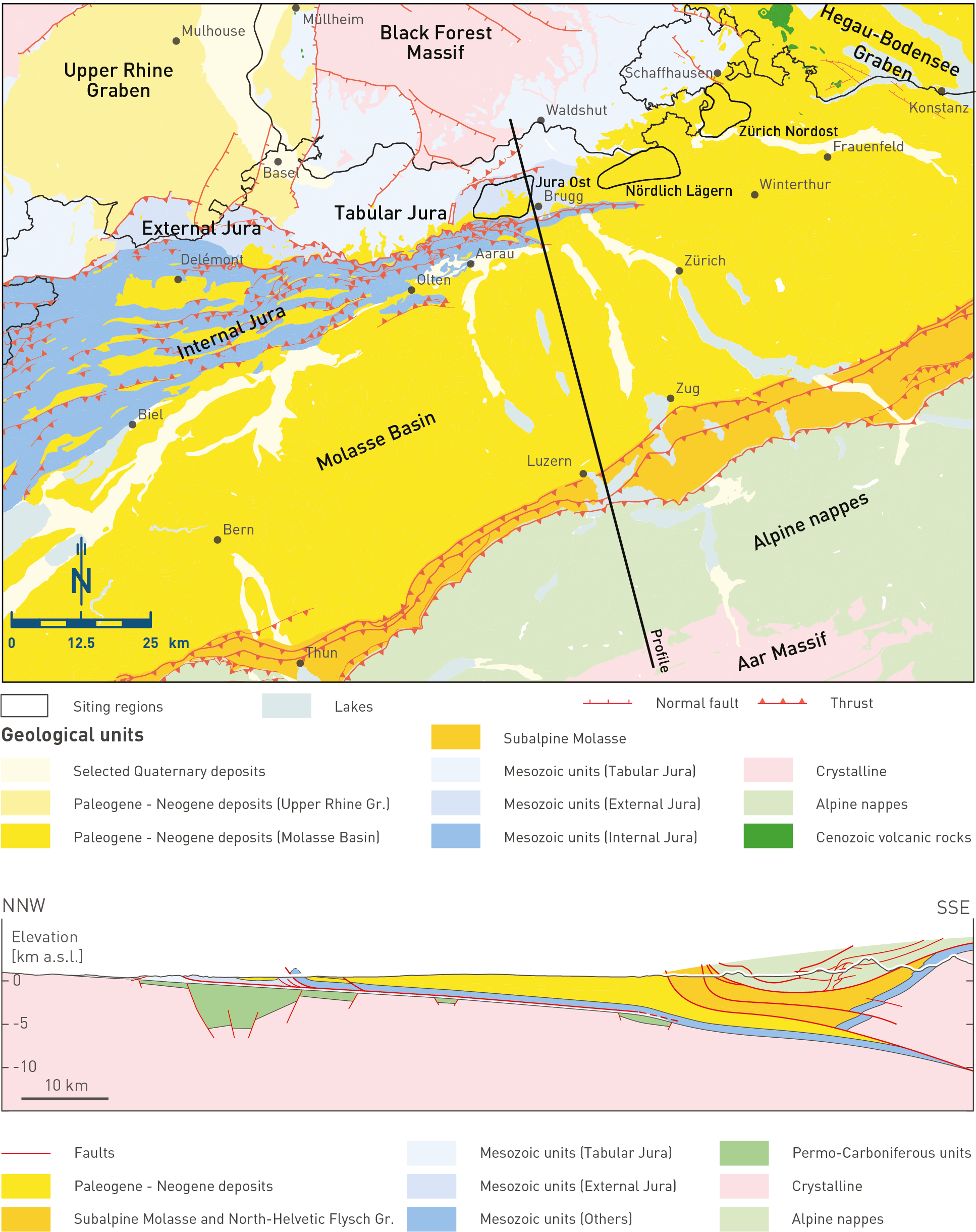
Fig. 3‑2:Simplified tectono-geological map of Northern Switzerland with a profile between the Aar Massif and the Black Forest Massif
Modified after Nagra (2014b). Geological map 1:500'000 was simplified (©swisstopo), i.e. no faults are shown within the Alps. Gr.: Graben (map above) or Group (cross-section below).
The Middle Miocene saw the opening of the Hegau – Bodensee Graben coeval with the deposition of medium- to fine-grained siliciclastic sediments on large debris fan systems (Upper Freshwater Molasse Group, OSM). The main deformation in the Jura Fold-and-Thrust Belt occurred within the Middle to Late Miocene to Pliocene, but it remains active until today.
During the Pliocene, the river drainage evolved from eastward-directed (Aare-Danube draining towards the Black Sea) to a westward- (Aare-Doubs draining towards the Mediterranean) and finally to a northward-directed system (Aare-Rhine draining towards the North Sea). During the Quaternary, glaciers advanced and retreated in the Alpine Foreland driven by glacial/ interglacial climate cycles. Together, these climate cycles, tectonic uplift and the progressive eastward migration of the Rhine River catchment resulted in fluvial and glacial incision. In the forefield of the glaciers, vast gravel plains were deposited. Glaciers also incised overdeepened troughs, which were filled by lacustrine sand and silt. With the disappearance of the glaciers in the North Alpine Foreland, fluvial and hillslope processes dominated the pre-sculptured landscape.
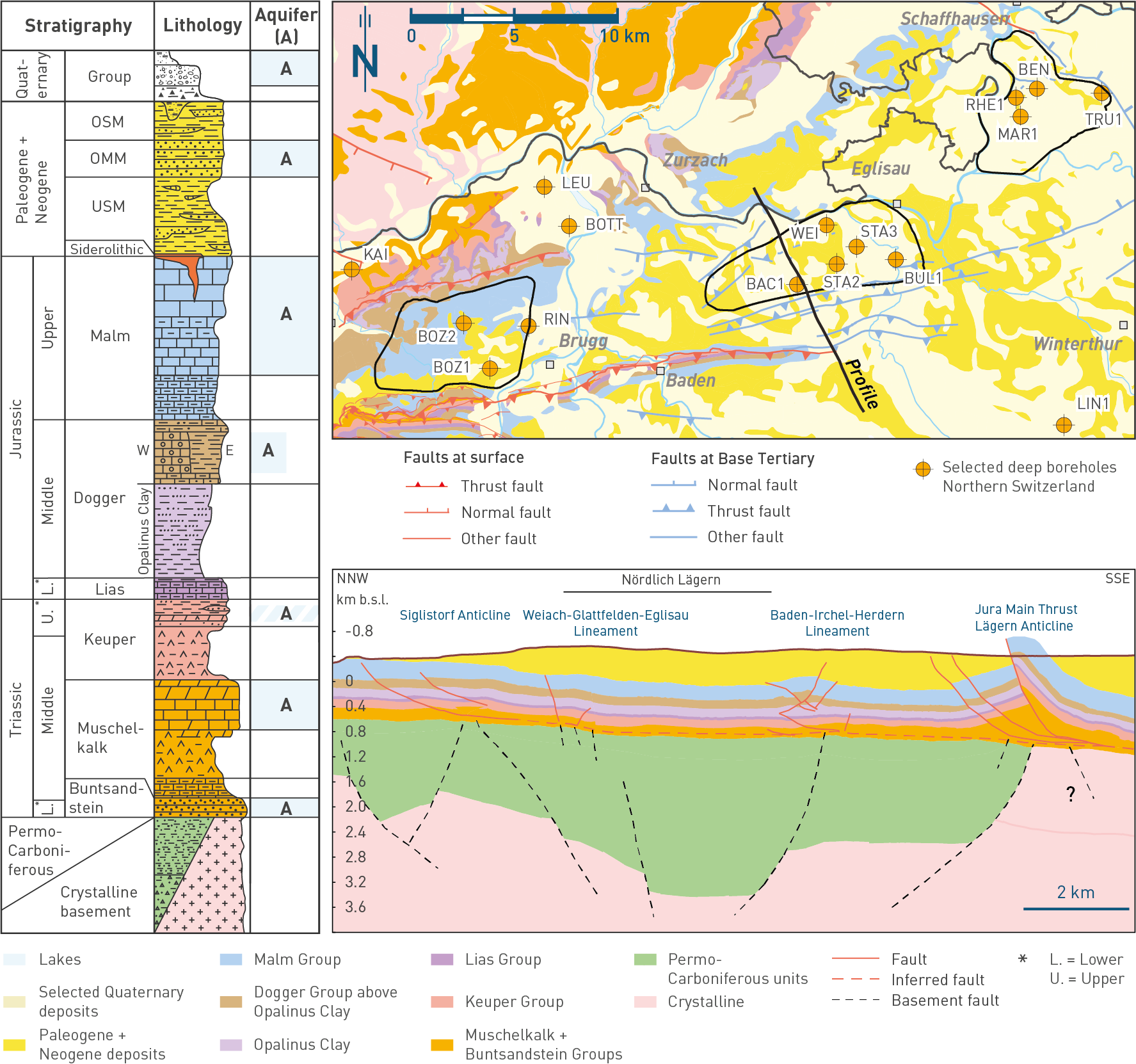
Fig. 3‑3:Stratigraphic column, geological map and profile of Northern Switzerland
Geological map modified after 1:500'000 geological map of Switzerland (©swisstopo). Cross-section modified after Meier et al. (2014) with the recent results from the 3D seismic interpretation.
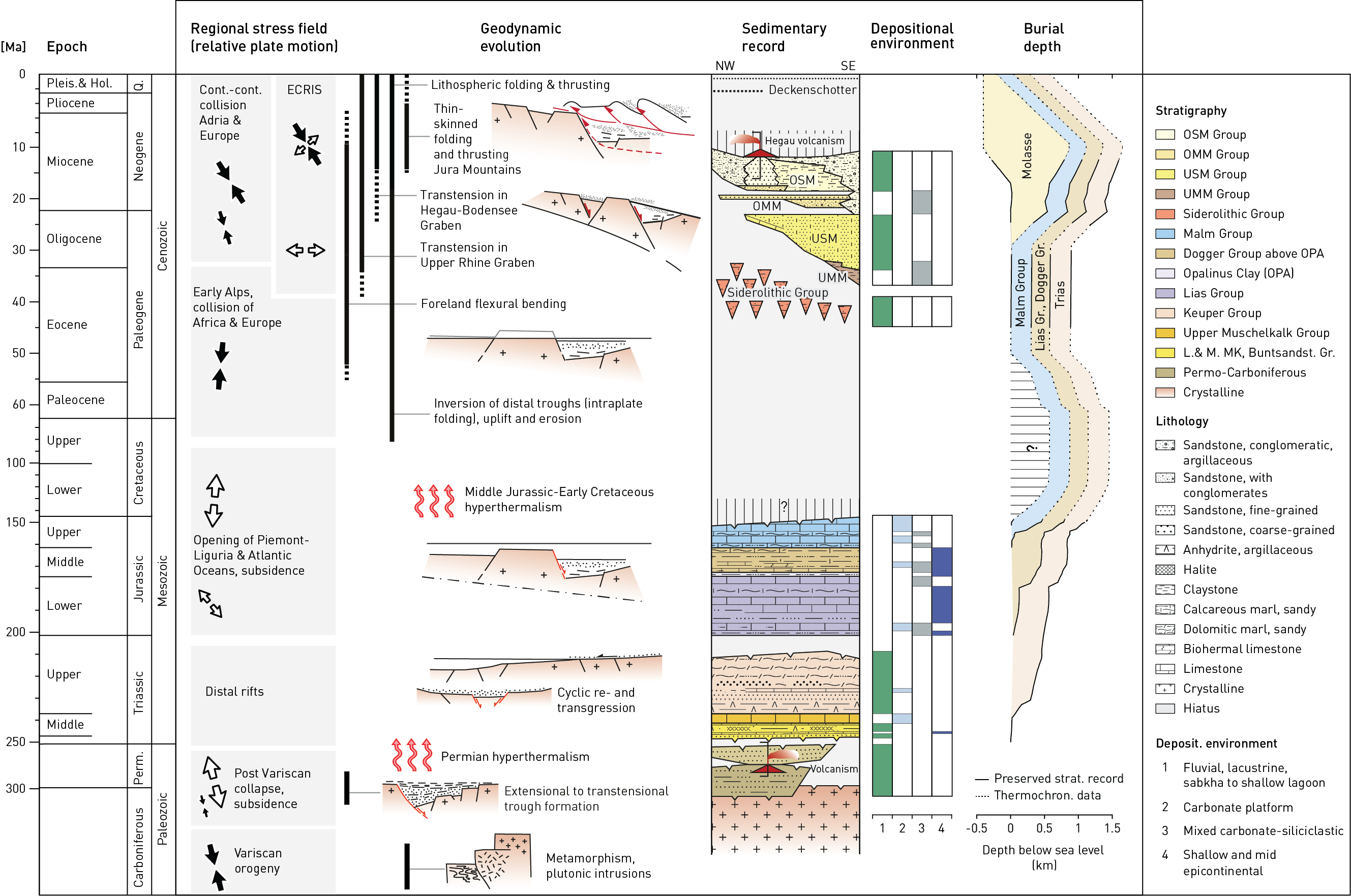
Fig. 3‑4: Timeline focusing on the geological evolution of Northern Switzerland
Modified after Müller et al. (2002). Large-scale stress field characteristics and tectonic events after Schori (2021), burial evolution after Mazurek et al. (2006). White arrows indicate tension-dominated stress field. Black arrows indicate compression-dominated stress field. Pleis.: Pleistocene, Hol.: Holocene, Q.: Quaternary, Perm.: Permian, Cont.: Continent, ECRIS: European Cenozoic Rift System, OSM: Upper Freshwater Molasse, OMM: Upper Marine Molasse, USM: Lower Freshwater Molasse, UMM: Lower Marine Molasse, Gr.: Group.
The geological framework of Northern Switzerland is largely controlled by the Pre-Mesozoic basement and the Variscan orogeny. The Pre-Mesozoic basement is composed of crystalline basement and overlying Permo-Carboniferous sedimentary troughs (Fig. 3‑3).
The crystalline basement is composed of polymetamorphosed, pre-Variscan sedimentary rocks and intrusive granites preserved as orthogneisses (Thury et al. 1994). Variscan metamorphism was accompanied by anatexis and intrusion of granite bodies and numerous dykes. Crystalline rocks from the Black Forest outcrops as well as from boreholes in Northern Switzerland show evidence for substantial post-metamorphic deformation and polycyclic hydrothermal alteration (Mazurek & Peters 1992).
The Variscan orogeny overprints the crystalline basement and was the result of the Late Paleozoic collision of Gondwana in the south and Laurussia in the north (Lorenz & Nicholls 1984, Stampfli & Borel 2002, Raumer et al. 2009). The main shortening phase of the Variscan orogeny occurred during the Carboniferous by strike-slip-dominated deformation, which produced NNE-SSW-trending faults (Rhenish orientation; Thury et al. 1994, Schori 2021). In addition, NW-SE-trending dextral shear zones formed (Hercynian orientation; e.g. Schori 2021 and references therein). Inherited NW-SE-trending faults also acted as zones of weakness during the later (i.e. Middle Miocene) subsidence of the Hegau – Bodensee Graben (e.g. Egli et al. 2017).
During into two phases. An initial strike-slip-dominated phase occurred after the Late Carboniferous and Early Permian, post-Variscan orogenic collapse gave rise to wrench tectonics and the formation of the Permo-Carboniferous Konstanz – Frick Trough in Northern Switzerland (Fig. 3‑4, Fig. 3‑6a; Diebold et al. 1991, Marchant et al. 2005, Naef & Madritsch 2014, Schori 2021). The kinematic evolution of the trough can be subdivided 334 Ma, recorded for instance by the offset of the Albtal granite (Madritsch et al. 2018). This was followed by a main subsidence phase with normal faulting localised along inherited structures (e.g. Vorwald Fault). With the formation of ENE-WSW-trending faults (i.e. Erzgebirgian trend) related to the graben formation, three fault orientations occur within the Paleozoic basement of Northern Switzerland and acted as zones of weakness localising future deformation (NW-SE-trending Hercynian, ENE-WSW-trending Erzgebirgian, NNW-SSE-trending Rhenish).
The central Konstanz – Frick Trough preserves a sedimentary succession reaching up to several km in thickness (Fig. 3‑2; Naef & Madritsch 2014, Madritsch et al. 2018), but significantly thinner on its shoulders. Based on boreholes drilled between the Upper Rhine Graben and the Bodensee area, a multiphase depositional history can be outlined. However, the detailed sedimentary succession remains poorly defined and is laterally variable. Volcanic activity also occurred during Permo-Carboniferous times, resulting in deposition of tuffites (Matter et al. 1988). Based mainly on the findings in the Weiach (WEI) borehole, three depositional phases were differentiated in the sedimentary succession (Matter et al. 1987, 1988, Diebold 1988, Madritsch et al. 2013):
-
Late Carboniferous times saw varying humid tropical conditions and deposition from anastomosing fluvial systems on externally drained fan complexes in the Konstanz – Frick Trough («Pre-Weitenau Formation deposits»). Fine- to coarse-grained sediments were deposited in fluvial channels, overbanks and floodplains. Organic-rich sediments were deposited in mires or shallow bog lakes on floodplains (later transformed into a few coal beds).
-
Late Carboniferous to Early Permian deposition («Pre-Weitenau Formation deposits») was characterised by anastomosing fluvial and lacustrine systems in a varying humid climate. Towards the end of this period, the relief surrounding the Konstanz – Frick Trough was generally flattened, leading to reduced sediment input.
-
During the Early to Middle Permian (Weitenau Formation; Fig. 3‑5a), the relief and erosion at the margin of the Konstanz – Frick Trough increased (Fig. 3‑6a) and vast alluvial plains developed with the deposition of locally reddish siltstone, fine- to coarse-grained sandstone and fanglomeratic breccias in an arid climate. Towards the end of the Permian, the landscape was generally flattened, forming a peneplain.
At the beginning of the Triassic Period, the relief formed during the Variscan orogeny was mostly eroded to form a peneplain. At that time, Northern Switzerland was part of the Central European Basin, separated from the Neotethys by the Vindelician – Bohemian Massif and the Alemannic Land (Fig. 3‑5b). Possible synsedimentary tectonics related to rifting are inferred to have given rise to variations in sediment thickness, observed along the bounding faults of the Konstanz – Frick Trough (Birkhäuser et al. 2001, Diebold et al. 1991, Pietsch et al. 2023).
During the Early to Middle Triassic, terrestrial and subordinately coastal sediments were deposited in an extensive intracontinental basin (Buntsandstein Group, Dinkelberg Formation). Fluvial systems sourced mostly from the west deposited a succession of fine- to coarse-grained sandstone and some clay-mineral-rich beds (Wurster 1968). Several phases of fluvial accumulation were followed by phases of pedogenesis.
The overlying Middle Triassic succession (Muschelkalk Group) preserves 3 depositional phases:
-
The first phase (Lower Muschelkalk Group, Kaiseraugst Formation) was deposited during a period of marine transgression. At this time, a succession of silt- and sandstone with wave ripples, crossbedding and bioclastic calcareous beds were deposited in sublittoral and beach settings, passing up into a shallow marine environment. These are overlain by silty claystone and argillaceous marl with silty to fine sandy and bioclastic beds which were deposited during a period of intermittent sea-level rise. These are, in turn, overlain by dolomitic marl, evaporitic beds and some sandy and calcareous beds which were deposited in an intertidal to lagoonal environment recording a subsequent regression.
-
These are overlain by a second depositional phase (Middle Muschelkalk Group, Zeglingen Formation) recording a period of significant regression and emergence (Dronkert et al. 1990, Pietsch et al. 2023). Deposition took place in lagoons, ephemeral ponds, salina and intertidal to supratidal areas attesting to arid conditions and records a number of shallowing-upward sedimentary cycles (Pietsch et al. 2023). These cycles comprise successions of dolostone, marl, claystone, anhydrite and partly halite. Some of the halite was subsequently dissolved syn- to mesogenetically during the Middle Triassic, leading to the formation of dissolution breccias.
-
The third phase of Middle Triassic deposition (Upper Muschelkalk Group, Schinznach Formation) records two subsequent marine transgressions and regressions (Pietsch et al. 2016, Adams & Diamond 2019). At this time, a temporarily open marine seaway was established, connecting the Central European Basin with the Neotethys. Deposition of micrite with scattered, locally oolitic, bioclastic beds took place in a shallow marine environment during a transgression and regression. During later diagenesis, the sediments were partially or completely dolomitised and, in bioclastic or oolitic beds, some open porosity developed (Stamberg Member). This phase ends with the deposition of fossiliferous claystone and dolostone in a littoral, deltaic to brackish environment during a subsequent transgression and start of a regression.
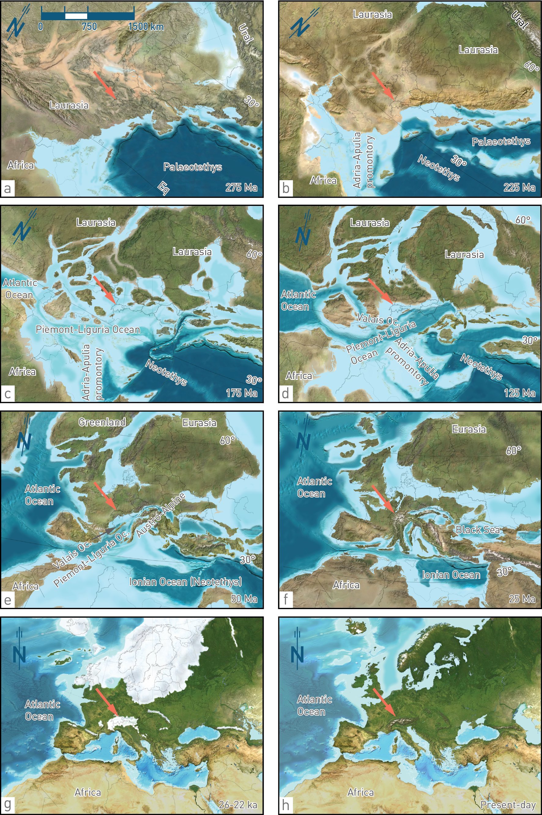
Fig. 3‑5:Palaeogeographic reconstruction showing Switzerland in the larger context
Modified after Palaeogeography of Europe ©2012 Colorado Plateau Geosystems Inc. The sediments of the following lithostratigraphic units were deposited during the presented time periods in Northern Switzerland: (a) Weitenau Formation, (b) Klettgau Formation, (c) Staffelegg Formation, (d) no sedimentary rocks preserved, (e) Siderolithic Group, (f) Lower Freshwater Molasse Group (USM), (g) Niederterrasse and (h) recent sediments.
Red arrows indicate the approximate location of Northern Switzerland. Eq: Equator; Oc.: Ocean.
Deposition at the southern extension of the Central European Basin during the Middle to Late Triassic (Keuper Group, Bänkerjoch Formation) took place during continued regression. At this time, terrestrial sediments were deposited in sabkha plains and comprised partly cyclic successions of chicken-wire anhydrite overlain by dolomitic claystone with thin anhydritic layers, in turn succeeded by claystone (Dronkert et al. 1990). The basin was influenced by sporadic marine incursions and deposition of dolomitic and sandy interlayers.
The Late Triassic succession (Keuper Group, Klettgau Formation; Fig. 3‑5b) was deposited in a largely terrestrial environment. As a result, sedimentary facies and thicknesses are highly variable, which is reflected in the heterogeneous Keuper aquifer in the three siting regions (Fig. 3‑3). Siliciclastic sediments were transported by rivers from the southern Norwegian Caledonides (Paul et al. 2008) and later from the Vindelician – Bohemian Massif and deposited on a continental playa under (semi)arid conditions (Fig. 3‑7; Jordan et al. 2016b). Deposits include sandstone-dominated fluvial channels and dolomitic marl-dominated floodplains, sometimes with pedogenic overprint. In the area of today’s Zürich Nordost (ZNO) siting region, porous dolomitic breccias were also deposited on the continental playa. Additionally, an intermediate marine transgression, from the southwest (Burgundy Gate) resulted in deposition of partly porous and bioclastic dolostone in the Jura Ost (JO) and Nördlich Lägern (NL) siting regions, and anhydrite in a shallow marine to coastal environment in ZNO. The youngest Triassic succession was also affected by two major erosional events, the Old Cimmerian and the Base Jurassic unconformities. As a result of the latter, Rhaetian sediments are completely absent over large areas.
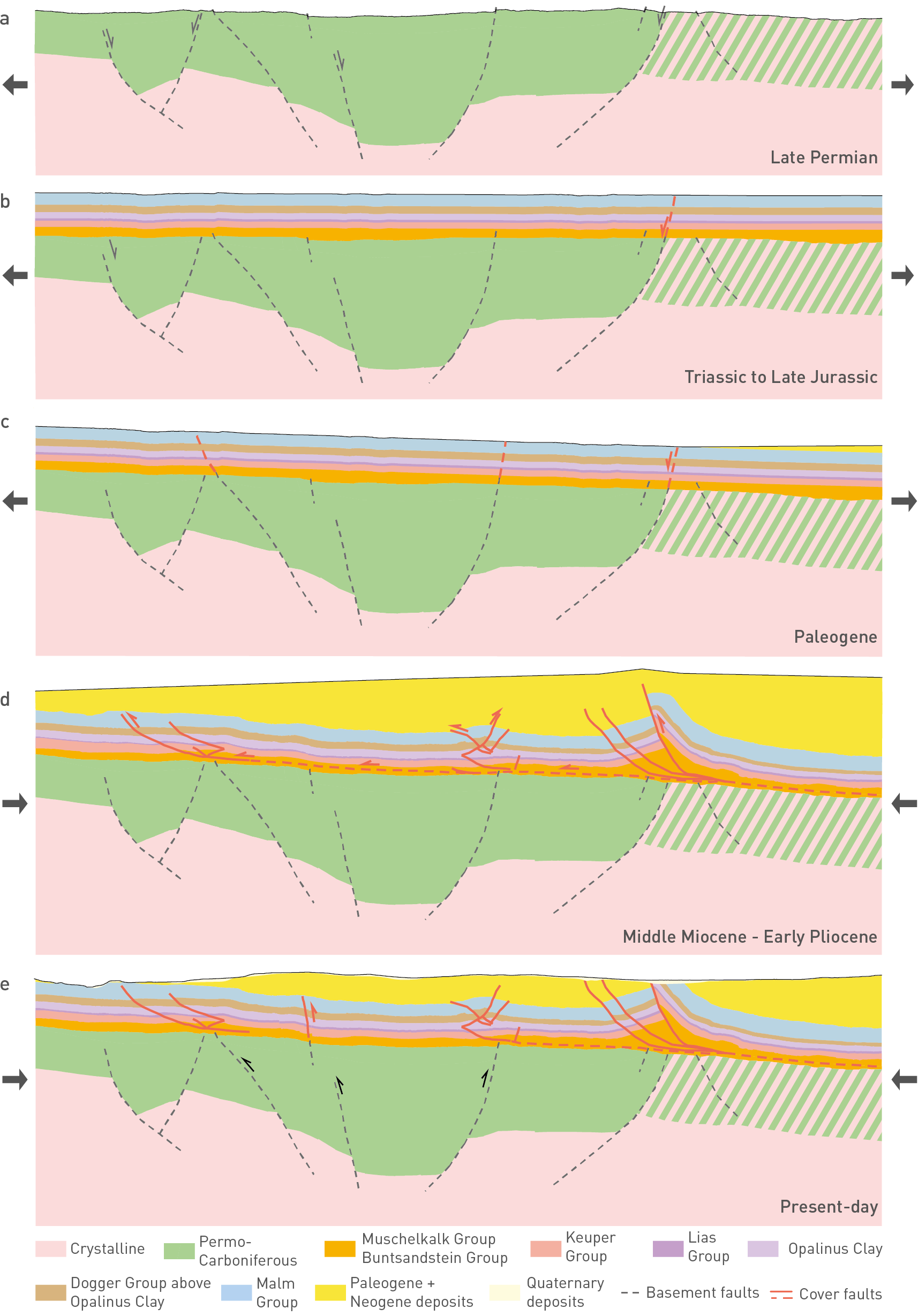
Fig. 3‑6:Geological evolution of the study area demonstrated on a schematic NNW-SSE cross-section
Black arrows are tentative indications for whether the time step was extension- or contraction-dominated. Green hatched zone reflects zone with Permo-Carboniferous or crystalline rocks.
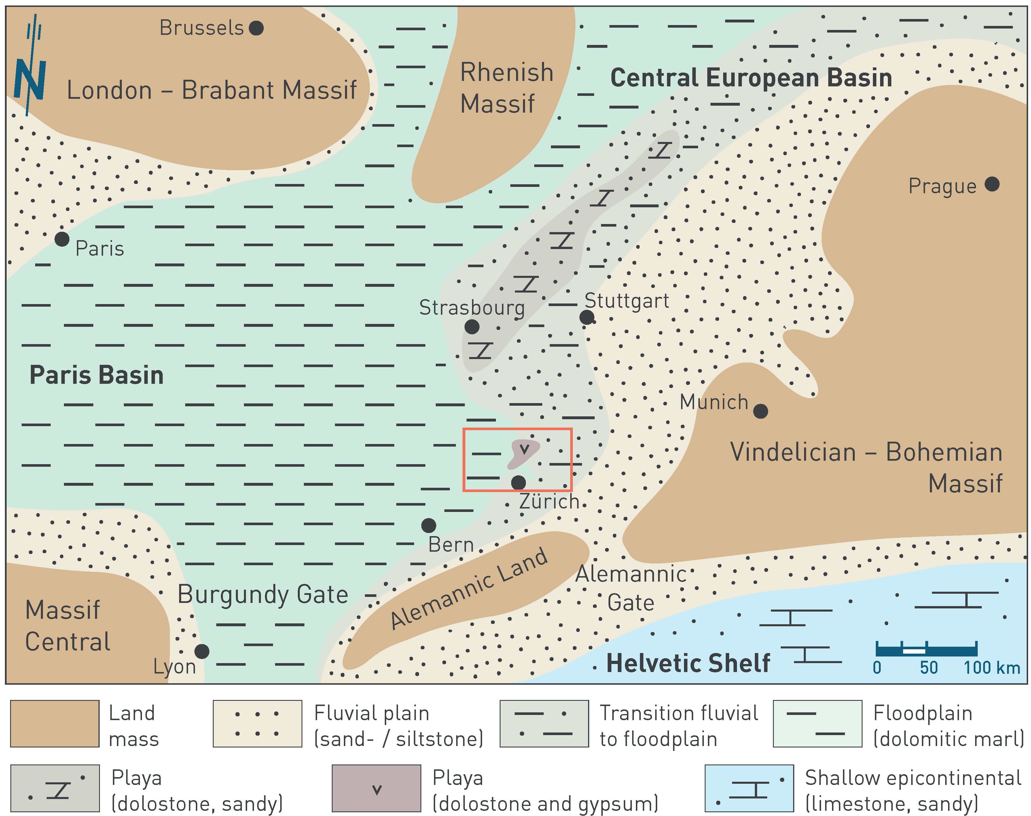
Fig. 3‑7:Palaeogeographic situation of Western to Central Europe in the Norian during the sedimentation of the Klettgau Formation (Seebi Member) and its time equivalents
The red rectangle shows the extent of the detailed palaeoenvironment maps (Section 4.2). Maps based on Geyer et al. (2023), Hagdorn & Nitsch (2009) and Pozsgai et al. (2017). The north arrow refers to present-day geographic north. The approximate locations of the cities are shown to simplify orientation.
The Jurassic Period was affected by the opening of the Atlantic Ocean and the associated development of the Piemont – Liguria Ocean (Schmid et al. 1996, Handy et al. 2010, Winkler 2024; Fig. 3‑5c). Associated extension gave rise to multiple pulses of increased heat flow that affected the burial history in Northern Switzerland (e.g. Mazurek et al. 2006). Peak Early Cretaceous burial temperatures are recorded in the Early Jurassic units.
During the Early Jurassic, Northern Switzerland continued to be in a shallow, subtropical to tropical epicontinental sea. It was bordered to the east and south by the Vindelician Land and its promontory, the Alemannic Land, in the area of the present-day External Crystalline Massifs. The Early Jurassic succession (Lias Group, Staffelegg Formation) is characterised by a condensed succession of calcareous hardgrounds with phosphatic and reworked nodules, and iron-oolites, with common reworking and multiple hiatuses (Reisdorf et al. 2011). In addition, there are phases with expanded deposition recorded by units of siltstone and partly organic-rich claystone. In Northern Switzerland, the different stratigraphic intervals can be well correlated.
During the Middle Jurassic, Europe was characterised by continued N-S-directed extension during the continued opening of the Piemont – Liguria Ocean. This was accompanied by development of a number of sedimentary basins preserving siliciclastic infill from surrounding landmasses and calcareous sediments from carbonate platforms (Dogger Group). Bottom currents played an important role in both transport and accumulation of these sediments.
The lower division of the Middle Jurassic succession comprises the Opalinus Clay. This was deposited in the shallow epicontinental sea located between the Vindelician – Bohemian Massif in the east, the Alemannic Land to the south and the very shallow area in Burgundy to the west (Fig. 3‑8). Within the shallow epicontinental sea deeper areas are referred as "shallow mid epicontinental". The accommodation space needed to deposit the compacted ca. 100 m thick unit of Opalinus Clay in relatively shallow water – especially considering uncompacted sediment thicknesses – was provided by regional subsidence (Wetzel & Allia 2003). High siliciclastic input from the Alemannic Land, the Vindelician – Bohemian Massif or landmasses even further to the northeast led to deposition of mostly claystone with varying contents of silt and fine sand over the entire Northern Switzerland (Lauper et al. 2021b, Zimmerli et al. 2024). This environment resulted in the deposition of the relatively homogeneous facies of the Opalinus Clay with little lateral variability compared with other Mesozoic formations of Northern Switzerland. Within the Opalinus Clay, a shallowing-upward trend, with increased silt and fine sand contents towards the top, is thought to reflect an overall regression (Zimmerli et al. 2024). Towards the top of the formation, reduced sedimentation is recorded by calcareous, partly iron-rich beds intercalated in claystone, which can be correlated on a local to regional scale (Wohlwend et al. 2024).
The overlying succession, Dogger Group above Opalinus Clay, preserves more lateral variability and complexity. A first phase of deposition largely comprises siltstone, claystone and argillaceous marl (Passwang Formation and its time equivalents in the east). However, local metre-scale beds or bedded intervals of sandy, bioclastic and biomicritic limestone were also deposited. Additionally, during episodes of reduced deposition, iron-rich, decimetre- to metre-scale beds, including iron-oolites were deposited. These sediments locally preserve cycles of claystone overlain by sandy and/or bioclastic marl, limestone and, finally, iron-oolitic beds. These cycles may represent shallowing-upward trends related to sea-level variations (Burkhalter 1996) and/or climate variability. The preservation of cycles is laterally highly variable, thought to be in response to local variations in bathymetry with local swells and depressions in combination with sediment transport by bottom currents. Such bottom currents may have locally (i.e. at the present location of NL) deposited a several-km-scale, clay-mineral-rich sediment drift. On top of this positive relief, an isolated carbonate platform consisting of mostly coral and bioclastic limestone developed («Herrenwis Unit»; Ruchat et al. 2024).
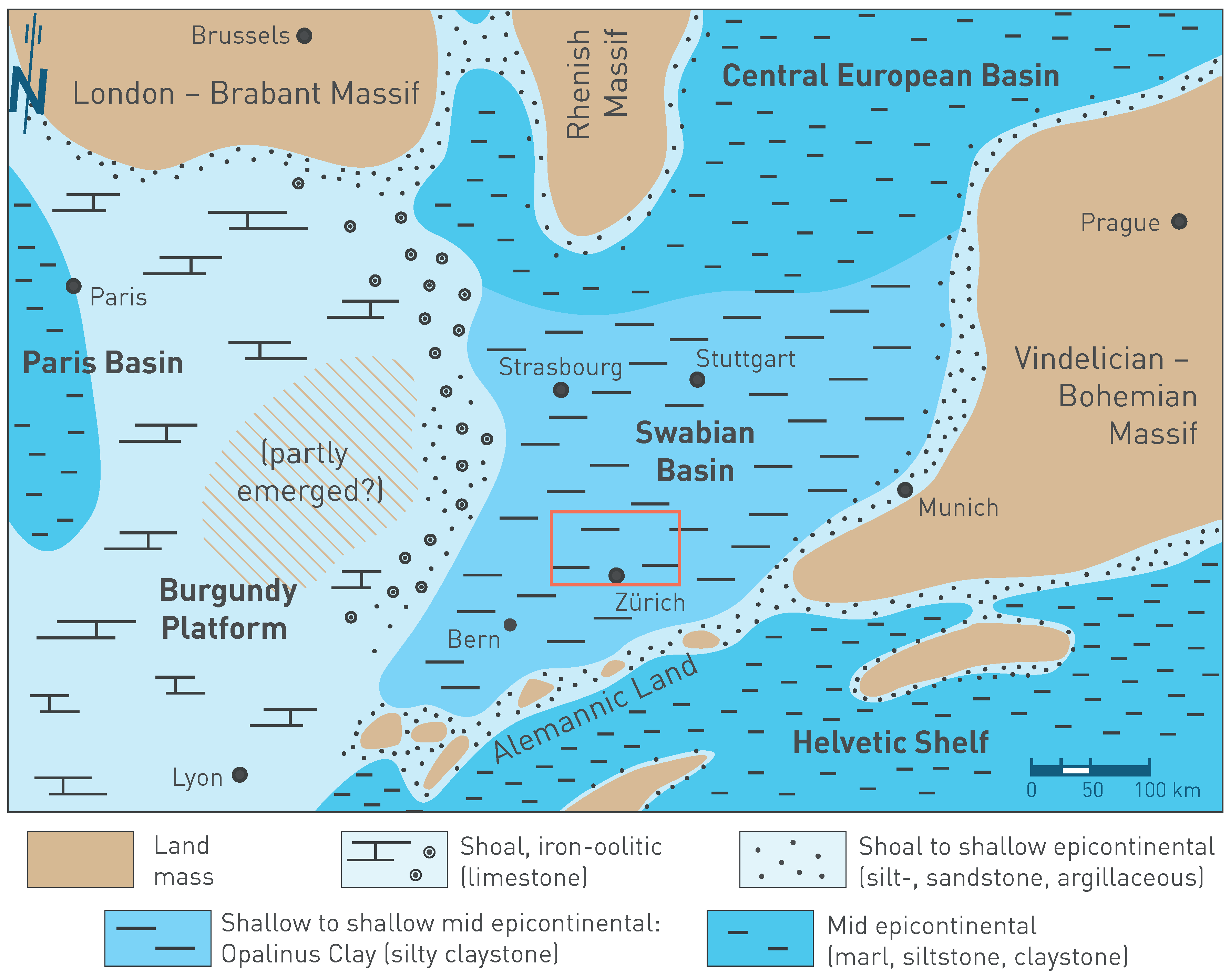
Fig. 3‑8:Palaeogeographic situation of Western to Central Europe in the Aalenian during the sedimentation of the Opalinus Clay and its time equivalents
The red rectangle shows the extent of the detailed palaeoenvironment maps (Section 4.2). Map based on Etter (1990) and Lauper et al. (2021a). The north arrow refers to present-day geographic north. The approximate locations of the cities are shown to simplify orientation.
In a second phase of deposition, the Celtic Platform extended into Northern Switzerland and oolitic and bioclastic limestone interbedded with some more marly interlayers (Hauptrogenstein) (Fig. 3‑9) were deposited in a shallow marine environment. Towards the Swabian Basin in the east calcareous marl with interfingering oolitic limestone prevailed (Klingnau Formation) while argillaceous marl, siltstone and claystone dominated further offshore («Parkinsoni-Württembergica-Schichten»). In NL, these sediments, probably in the form of sediment drifts, filled the basin and finally also covered the isolated carbonate platform, so that the «Herrenwis Unit» is embedded in clay-mineral-rich sedimentary rocks. The third phase of deposition is again characterised by a condensed succession of often fossiliferous, iron-oolitic marl and limestone (mostly Ifenthal and Wutach Formations; Bitterli-Dreher 2012, Bläsi et al. 2013).
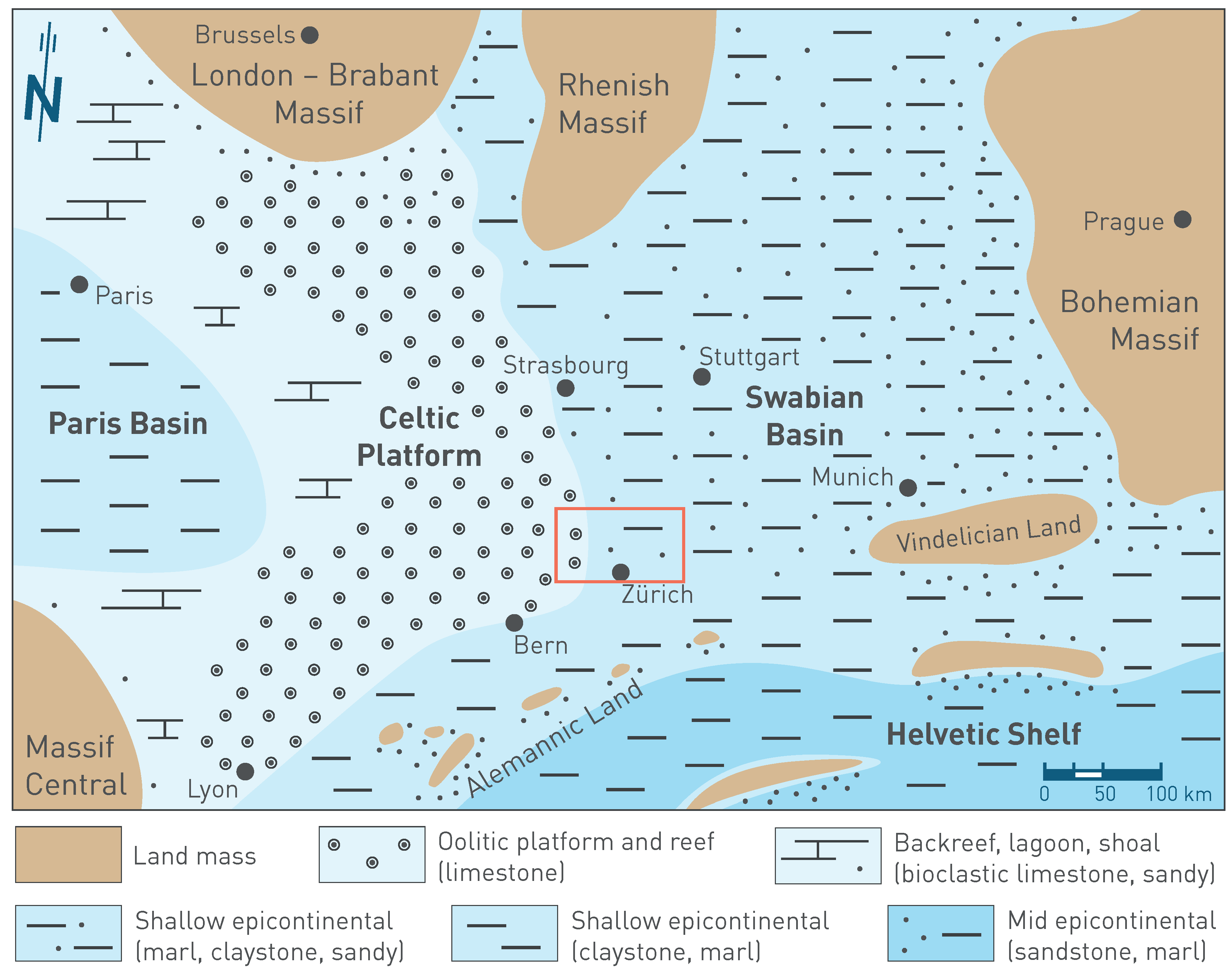
Fig. 3‑9:Palaeogeographic situation of Western to Central Europe in the Bajocian during the sedimentation of the Hauptrogenstein and «Parkinsoni-Württembergica-Schichten» and their time equivalents
The red rectangle shows the extent of the detailed palaeoenvironment maps (Section 4.2). Map based on Barron et al. (2012), Correia (2018), Geyer et al. (2023), Gonzalez & Wetzel (1996), Krakow & Schunke (2017), Munier et al. (2021) and Védrine & Strasser (2009). The north arrow refers to present-day geographic north. The approximate locations of the cities are shown to simplify orientation.
During Late Jurassic times (Malm Group), the Swabian Basin including Northern Switzerland formed part of a shallow epicontinental sea (Fig. 3‑10). The nearest landmasses were the London – Brabant, Rhenish and Bohemian Massifs in the north and east. To the south, the shelf sea merged into the Piemont – Liguria Ocean (Geyer et al. 2023). Overall, the Late Jurassic formations show considerably less lateral variability than the underlying succession (Dogger Group above Opalinus Clay).
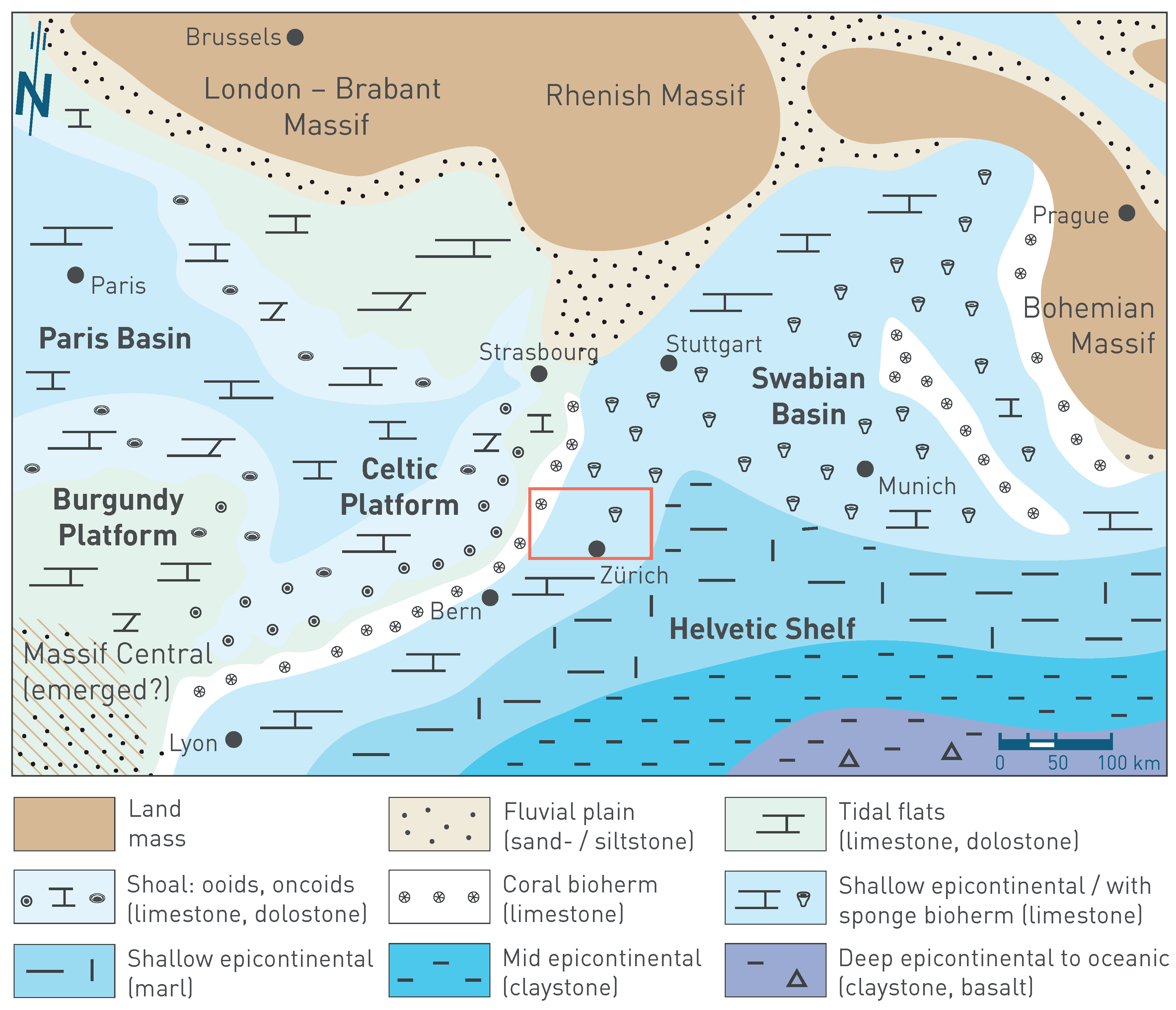
Fig. 3‑10:Palaeogeographic situation of Western to Central Europe in the Kimmeridgian during the sedimentation of the Burghorn Formation, «Felsenkalke» and «Massenkalk» and their time equivalents
The red rectangle shows the extent of the detailed palaeoenvironment maps (Section 4.2). Map based on Diedrich (2011), Geyer et al. (2023), Gouffon (2024), Gygi (2012), Jank et al. (2006), Koppka (2015), Krakow & Schunke (2017), Marty et al. (2007), Meyer & Schmidt-Kaler (1996), Püntener et al. (2015), Rauhut et al. (2017) and Schmid et al. (2005). The north arrow refers to present-day geographic north. The approximate locations of the cities are shown to simplify orientation.
Late Jurassic deposition started with a phase of reduced sedimentation that was followed by deposition in a more basinal setting or carbonate ramp (Swabian facies realm) adjacent to a carbonate platform located farther to the northwest (Celtic facies realm). The sedimentary rocks are dominated by calcareous marl and limestone, where regular interlayering is thought to reflect variations in climate and sea level (Wildegg Formation). In Northern Switzerland, the depositional centre was situated in the west, and sediment thicknesses decreased considerably towards the east. The region with the thickest sediment successions might reflect highest differential subsidence and/or highest accumulation by bottom currents (Allenbach 2002). Subsequently, predominantly micritic limestone (Villigen Formation, «Felsenkalke») with local bioherms (sponge reefs, «Massenkalk»), intercalated with more marly sediments (Schwarzbach Formation), were deposited in the shallow Swabian Basin. The youngest preserved Mesozoic sedimentary rocks in Northern Switzerland are of Kimmeridgian age; younger Mesozoic sedimentary rocks were eroded (Fig. 3‑4, Fig. 3‑6b, Section 3.3.3; Gygi 2012).
Cretaceous deposits in Northern Switzerland are either eroded or have not been deposited. However, Cretaceous times saw the development of the Alps. The Alps can be subdivided into two domains. The Eastern Alps and the Western Alps. The Eastern Alps are the result of two orogenies (Eo-Alpine and Alpine) and the Western Alps only of the Alpine orogeny. The Alps evolved in response to collision of the Adriatic promontory of the African plate with the European continent. Collision involved the decoupling of the subducting European slab from the Alpine nappe stack and tectonic underplating / accretion of the European upper crust to the Alpine wedge (Schmid et al. 1996, Escher et al. 1997, Schmid et al. 2004, Schlunegger & Mosar 2011). N- to NNE-directed convergence of the Adriatic plate started during the Cretaceous, leading to the progressive closure of the Piemont – Liguria and Valais Oceans (Stampfli et al. 1998).
The main phase of the Alpine orogeny occurred during the Paleogene and Neogene (e.g. Schmid et al. 2004. Paleocene times saw continued closure of the Piemont – Liguria and Valais Oceans as well as troughs such as for instance the Cormoz High, a NNE-SSW-trending Paleozoic line in the Bresse Graben (Schori 2021).
In the Central Alps, emplacement of the Penninic nappes occurred in the Early Eocene, whereas the Helvetic domain was affected by N- to NNE-directed thrusting from the Late Eocene onwards (Pfiffner 2009). In the Late Eocene to Early Oligocene, the opening of the Upper Rhine Graben, part of the European Cenozoic Rift System (ECRIS), was accompanied by subsidence and associated with uplift of the graben shoulders (Rotstein & Schaming 2011). This extensional system extended from the Bohemian Massif to the Mediterranean Sea (Bourgeois et al. 2007). The development of the Upper Rhine Graben can be subdivided into an early extensional phase which was followed by a transtensional phase. The transtensional phase is characterised by a NW‑SE-oriented maximum horizontal stress axis and is thus comparable to the present day. The closure of the Piemont – Liguria and Valais Oceans that initiated in the Late Cretaceous was completed in the Eocene, marking the onset of continental collision (Handy et al. 2010). Lithospheric folding resulting from the continental collision is proposed to result in surface uplift of the North Alpine Foreland (Fig. 3‑4; Dèzes et al. 2004, Bourgeois et al. 2007).
During the Eocene (Fig. 3‑5e), a humid and warm (sub-) tropical climate formed an extensive karst landscape on the exposed Mesozoic bedrock. The residual material of the strong chemical weathering, consisting of mostly clay minerals, quartz sand, and ironhydroxide pisoids, was accumulated in palaeokarst depressions and infills (Siderolithic Group). The surface topography was probably hills and valleys partly covered by tropical forest with a species-rich fauna including primates and crocodiles (Rosselet 1991).
The change to erosive conditions between the Late Cretaceous and Early Eocene preluded a ca. 50-Myr-long period of recharge of meteoric waters in Northern Switzerland. This caused karstification extending several decametres into the Malm Group (filled palaeokarst). Over the long timescale, the freshwater conditions in the Malm aquifer caused an overprinting of the initial marine porewaters in the Opalinus Clay and the confining units (Section 4.6.5).
The Oligocene represents the time of major deformation in the Helvetic domain of the Central Alps with the emplacement of the Helvetic nappes (Pfiffner 2009). The development of the Alpine Foreland basin can be explained by flexural bending of an elastic lithospheric plate as a response to crustal loading resulting from internal build-up of the Alps (e.g. Willett & Schlunegger 2010) or slab roll-back and associated buoyancy-driven uplift (Schlunegger & Kissling 2015).
During the Early Oligocene, Northern Switzerland was still characterised by a karst landscape. Locally, nodular and crustal limestone formed under arid to semiarid conditions («Ältere Krustenkalke»; Hofmann et al. 2000). At this time, the emerging Alps led to an increased sediment supply and deposition in the northern Alpine foredeep, firstly as deep marine North-Helvetic Flysch Group and then as shallow marine to littoral sediments of the Lower Marine Molasse Group (UMM; e.g. Kuhlemann & Kempf 2002).
During the Late Oligocene (Fig. 3‑5f), the increasing crustal loading or slab dynamics resulted in foredeep migration and migration of Molasse deposition from southeast to northwest (Allen et al. 1991, Sinclair & Allen 1992, Kuhlemann & Kempf 2002, Ford et al. 2006, Schlunegger & Kissling 2015). The adjacent forebulge also migrated northwards and was associated with erosion and normal faulting (e.g. Laubscher 1985, Jordan et al. 2015).
The former marine Alpine Foreland basin was progressively infilled, passing into terrestrial fluvial systems. The Lower Freshwater Molasse Group (USM) was deposited on large debris fan systems, which drained towards northeast to east. Deposition from Alpine River systems migrated over time towards the northwest. In a NNW-SSE cross-section, a wedge-shaped sedimentary body developed with coarse clastic debris fan series with conglomerates («Nagelfluh») in the near-Alpine, proximal area and silty-sandy-marly sediments of rivers and floodplains in the distal area (Schlunegger et al. 1997). No deposits of USM occur in the JO siting region (eroded or not deposited), except for the southeastern-most part near Villnachern. USM is preserved in distal facies in the NL and ZNO siting regions.
Continued uplift of the Upper Rhine Graben rift shoulders (i.e. Black Forest and Vosges Massifs) in the Miocene caused local extensional reactivation of inherited structures. Furthermore, it resulted in tilting of the pre-Mesozoic basement towards the south, which was further enhanced by the flexural lithospheric bending and folding (e.g. Laubscher 1992, Dèzes et al. 2004, Berger et al. 2005). As a consequence, the Mesozoic sedimentary cover of the Black Forest area was emergent and eroding. The eroded material was deposited in conglomeratic units containing Mesozoic detritus in parts of Northern Switzerland and adjacent Germany (Jura Nagelfluh). As a result of the uplift and erosion in the Black Forest area, meteoric waters could directly infiltrate into increasingly deep aquifers.
At the beginning of the Miocene, deposition of USM continued with interruptions. In Northern Switzerland, USM, dominated by Alpine material, is found up to a line from Brugg via Schaffhausen into the Hegau (Fig. 3‑2), where it partly interfingers with conglomerates of the Malm Group limestone from the Black Forest area («Ältere Juranagelfluh»).
In the Early Miocene (since ca. 21 Ma), subsidence led to transgression of the sea from the Rhone Valley. Eventually, it formed the narrow, around 100-km-wide Burdigalian seaway connecting the Mediterranean in the southwest (Lyon) with the Paratethys in the northeast (Vienna). The Upper Marine Molasse Group (OMM) was deposited in a shallow marine coastal environment. It comprises glauconitic sandstone and marl with scattered units of fossiliferous conglomerate («Quarzit Nagelfluh», «Austernnagelfluh»), some containing pebbles of Jurassic origin («Mittlere Juranagelfluh»; Jost et al. 2016). The OMM is characterised by facies changes over small distances and several erosional unconformities. In the latest Early Miocene (after ca. 17 Ma), the sea had largely retreated, and a river system formed running SW across the Hegau and Schaffhausen (Fig. 3‑2). This locally incised up to 100 m deep into the older Molasse deposits. At this time, extensive quartz-rich sandstone was deposited in the so-called "Graupensandrinne" in a brackish depositional environment (Bolliger 1999). Overall, the OMM is commonly missing in the JO siting region, presumably because this area was located outside or near the northern coastline of OMM and affected by later erosion. Relicts of OMM can also be found in the eastern part of JO (Diebold et al. 2006).
The marine to brackish conditions during the Upper Marine Molasse Group (OMM) deposition were the latest marine phase in Northern Switzerland. Remnants of these marine waters can be sampled in deep boreholes from the Molasse (OMM, USM) and from the Malm aquifer (Section 4.5.5.2). Additionally, calcite veins in the Upper Jurassic Effingen Member in the Oftringen (OFT) borehole are related to the infiltration of OMM groundwater (de Haller et al. 2011, Mazurek et al. 2018).
From the beginning of the Middle Miocene, continental conditions prevailed again throughout the Alpine Foreland in Northern Switzerland and the terrestrial deposits of the Upper Freshwater Molasse Group (OSM) were deposited. Large debris fans built up at the Alpine front, flowing N and NW into a broad southwest-flowing stream system, the "Glimmersandrinne" (Zaugg & Vogel 2014). The NL and ZNO siting regions are situated in a distal setting of these debris fans ("Hörnli-Schuttfächer"), which are dominated by marl, silt- and sandstone. In JO, fluvial conglomeratic layers («Jüngere Juranagelfluh») with pebbles of Malm and Dogger Groups from the southern Black Forest were also deposited. These are intercalated with marly, silty and sandy sedimentary rocks (Diebold et al. 2006).
Activity of the Hegau – Bodensee Graben located northeast of the study area is dated to Early to Middle Miocene based on correlation of OMM sedimentary rocks across the Randen Fault (Schreiner 1992, Hofmann et al. 2000, Egli et al. 2017, Ibele 2015). The main tectonic activity in the Hegau – Bodensee Graben occurred between the Late Miocene and the Pliocene in a transtensional manner (e.g. Ibele 2015, Egli et al. 2017). Volcanic activity dated to 19 to 6.9 Ma accompanied the early extension-dominated phase of the Hegau – Bodensee Graben (Ibele 2015 and references therein).
Early to Middle Miocene (20 to 13 Ma) thrusting of the External Crystalline Massifs over the sedimentary cover resulted in their exhumation (Herwegh et al. 2017, 2020). It is a likely cause for the NW propagation of the Alpine thrust front along the Triassic evaporites, which are generally considered as décollement horizons (Fig. 3‑6d; Marro et al. 2023, Burkhard 1990, Sommaruga et al. 2017, Jordan & Nüesch 1989). The front of the detached Mesozoic strata strikes north of the JO and NL siting regions and runs through the southern part of ZNO. Thermochronological data from the Schafisheim (SHA) borehole located south of the Jura Main Thrust show that tectonic activity along the basal décollement is constrained to have started during the Middle Miocene (Fig. 3‑6d; 14.3 Ma; Looser et al. 2021). Similar age ranges were documented for the western Jura (Smeraglia et al. 2021). No evidence for shortening related to the Alps in the distal foreland is known east of Zürich; the shortening was most probably accommodated within the Subalpine Molasse (Burkhard 1990, von Hagke et al. 2012, Ortner et al. 2024).
The combination of age dating and 2D geometric balancing of selected cross-sections indicated maximum shortening rates during the main thin-skinned Jura Fold-and-Thrust Belt formation of around 0.5 mm/yr (for the time period 14.3 to 4.5 Ma, i.e. linked to the décollement activity in the SHA borehole) for the western part of JO (Jordan et al. 2015, Madritsch et al. 2024).
The youngest preserved Molasse sedimentary rocks in Northern Switzerland are approximately 11.5 Ma old (Rahn & Selbekk 2007). However, sedimentation continued within the Swiss Molasse Basin that evolved from a flexural foreland basin to a wedge-top basin as a result of the formation of the Jura Fold-and-Thrust Belt (e.g. Cederbom et al. 2004, Schlunegger & Mosar 2011, Schlunegger & Kissling 2015, Willett & Schlunegger 2010). Deposition of the Cenozoic sedimentary rocks resulted in a second burial of the Mesozoic strata (Mazurek et al. 2006), whereby maximum temperatures decreased with increasing distance from the Alpine front, reflecting the wedge geometry of the Molasse deposits. For the distal margin of the Molasse, thermal history modelling based on vitrinite reflectance and thermochronological data suggests that, before the onset of Miocene erosion, the Molasse thickness in the Weiach – Benken area was approximately 1 km greater than today (e.g. Mazurek et al. 2006).
The main phase of thin-skinned deformation within the Jura Fold-and-Thrust Belt is thought to extend from the Middle Miocene until the Early Pliocene (Fig. 3‑6d; e.g. Becker 2000, Schlunegger & Mosar 2011, Mosar 1999). Undeformed infilled karst features in folded Malm limestones of the Vue-des-Alpes Anticline (located in the Central Jura Fold-and-Thrust Belt, i.e. west of the study area) were dated from 4.2 to around 3 Ma and thus locally represent the end of the main deformation phase in the Internal Jura (Bolliger et al. 1993, Steininger et al. 1996). Nonetheless, several studies examining the front of the Jura Fold-and-Thrust Belt have identified evidence of moderate post-Pliocene tectonic thick-skinned (i.e. involving the substratum beneath the décollement horizon) activity (e.g. Giamboni et al. 2004, Madritsch et al. 2010). Geodynamic considerations support that the more recent deformation also affects the units below the décollement rather than being exclusively thin-skinned deformation (e.g. Mosar 1999; Fig. 3‑6e). In fact, interpretations of seismic reflection data from west of Basel indicate a component of thick-skinned deformation starting from the Late Pliocene onwards (Ustaszewski & Schmid 2007, Madritsch et al. 2008). This inferred basement involvement is also observed in the latest 3D seismic reflection data obtained by Nagra (Section 4.3; Nagra 2024b).
From the latest Miocene into the Pliocene (ca. 7.3 – 4.2 Ma), the North Alpine Foreland drained towards the northeast to the Black Sea via the Aare-Danube River system (Fig. 3‑11; Heuberger et al. 2014, Yanites et al. 2013, Ziegler & Fraefel 2009). This river system is documented by gravel relicts up to 270 m above the recent valley floor of the upper Danube River mostly between Blumberg and Ulm (Aare – Donau Höhenschotter; Villinger 2003). Later in the Pliocene (ca. 4.2 – 2.9 Ma), the Aare – Doubs System draining towards the Rhone and the Mediterranean Sea was established when the Aare-Danube River was captured by the proto-Doubs River in the region of Waldshut. This river reorganisation is potentially related to the sea-level drop in the Medi-terranean Sea during the Messinian salinity crisis resulting from isolation from the Atlantic Ocean (ca. 5.5 Ma; Krijgsman et al. 1999) and a successive backward incision of the palaeo-Rhone and Doubs systems. Alternatively, the headward erosion along the proto-Doubs River could have been caused by strong subsidence in the Bresse Graben (Schlunegger & Mosar 2011). Part of the eroded material was deposited west of Basel and is partially preserved in the form of the Sundgau Gravel (Liniger 1967) and its equivalents in the Forêt de Chaux (northeastern Bresse Graben; Petit et al. 1996).
Towards the end of the Pliocene at the transition to the Quaternary, the Aare – Rhine System, draining towards the North Sea, was established when the Aare-Doubs River was captured by the proto-Rhine River in the region north of Basel. This gave rise to the first deposition of Alpine sediments in the Upper and Lower Rhine Graben (ca. 2.8 – 2.6 Ma; Hagedorn & Boenigk 2008, Westerhoff et al. 2008). The timing and course of these river systems in the Pliocene are subject to larger uncertainty because of sparse sedimentological records and scarce chronological information.
The flow distance from the study area along the Danube towards the Black Sea is considerably larger compared to the flow distance of the Rhine River towards the North Sea. The modern Danube catchment is located more than 200 m higher compared to the Rhine catchment. This difference may have been even more pronounced in the past when the water divide was located farther to the west. For this reason, the change from the Danube to the Rhine system led to a signi-ficant baselevel fall and triggered a subsequent incision wave across the study area and the Central Swiss Molasse Basin (Schlunegger & Mosar 2011, Heuberger et al. 2014, Yanites et al. 2013).
The groundwater flow systems in the bedrock aquifers are influenced by the evolution of topography and of the river network. The Pliocene incision of the Rhine and Aare Rivers affected the regional discharge zones for the deep groundwaters of the Swiss Molasse Basin and of the sedi-mentary cover of the Black Forest (e.g. Waber & Traber 2022).
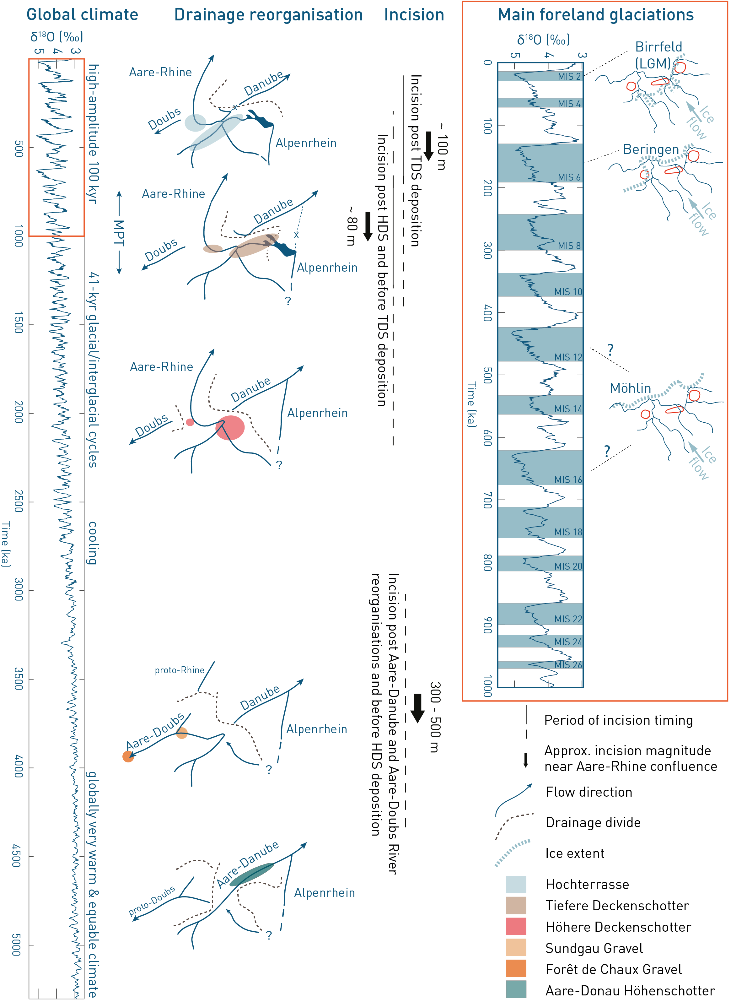
Fig. 3‑11:Main landscape-forming events in Northern Switzerland during the past 5 Myr
Compilation shows global and regional events linked to the Pliocene-Quaternary landscape evolution in Northern Switzerland. δ18O record with marine isotope stages (MIS) based on Lisiecki & Raymo (2005). Incision magnitudes of major drainage reorganisations are based on visual inspection of the Aare – Rhine confluence area based on Heuberger et al. (2014) and yield ~ 300 – 500 m for the Aare-Doubs incision, ~ 80 m between HDS (Höhere Deckenschotter) and TDS (Tiefere Deckenschotter) deposition and ~ 100 m after TDS deposition. Maps with ice extents show present-day river network for orientation.
The Quaternary landscape evolution is driven mostly by tectonics, climate, and river drainage reorganisations in Northern Switzerland (Nagra 2024k). The tectonic setting is determined by ongoing Alpine orogeny, transtensional deformation within the Upper Rhine Graben, tectonic activity of the Jura Fold-and-Thrust Belt and the Hegau – Bodensee Graben. The dominant Alpine-related uplift produced a general uplift gradient oriented perpendicularly to the Alpine front with rates that decline towards the NNW (Nagra 2024l).
The Quaternary climate is globally characterised by a series of glacial and interglacial periods. These glacial/interglacial cycles are mainly driven by oscillations in the Earth’s orbit and axial tilt, which affect the distribution of solar radiation. Cooling and warming periods have been divided into marine isotope stages (MIS) based on isotope data derived from deep-sea core samples (Lisiecki & Raymo 2005). Alpine glaciers advanced and retreated dynamically in concert with the global climate cycles and largely depended on local Alpine temperature and humidity. During pronounced global glacial periods, the Alpine glaciers reached the Alpine Foreland (Fig. 3‑5g, Fig. 3‑11; Nagra 2024j). During the so-called Mid-Pleistocene Transition (ca. 1.25 – 0.7 Ma; Clark et al. 2006), the principal glacial/interglacial cycle changed from a dominant 41‑kyr to a 100-kyr period (Fig. 3‑11). The cause for this transition remains debated, potential candidates include ice-dynamic, oceanic and atmospheric feedbacks (Berends et al. 2021). Large glaciations have reached the foreland since the Early Pleistocene (Schlüchter et al. 2021) but probably had their largest erosion potential only within the last one million years, when cyclicity changed to a high-amplitude 100-kyr glacial/interglacial cycle (e.g. Preusser et al. 2011). At that time, glaciers eroded into the bedrock below the fluvial baselevel, creating major overdeepened valleys in the Swiss Plateau Molasse.
During the Quaternary, the Rhine River system evolved in several phases of drainage reorganisation that resulted in significant drops in the local baselevel (Fig. 3‑11). The drainage divide between the Rhine and the Danube system continued to shift eastwards because of the headward erosion of the Rhine River and its precursors. This shift was probably facilitated by glacial erosion and deposition. Since late Early Pleistocene to Middle Pleistocene, the Alpenrhein River no longer drains northwards into the Danube River, but towards the Hochrhein River (Ziegler & Fraefel 2009, Heuberger et al. 2014).
In the Early Pleistocene (2.6 – 0.77 Ma), the Alpine glaciers advanced into the Alpine Foreland for the first time. Rare findings of ice-contact sediments indicate that some Early Pleistocene glaciers advanced to similar extents to that reached, for instance, during the Last Glacial Maximum (LGM; Fig. 3‑5g). Downstream of these glaciers, extensive plains with fluvioglacial gravels were aggraded in wide channel systems (Graf 1993). Fluvial incision resulted in the development of gravel terraces, leaving behind flat-topped hills in the landscape, the so called Höhere and Tiefere Deckenschotter ("Higher and Lower Cover Gravels"; Fig. 3‑11). In this progressively incising fluvial system, older gravel terraces are generally preserved at higher elevation, while younger terraces are at lower elevation (Burbank & Anderson 2012). Many of the Deckenschotter terrace bodies are further characterised by a composite internal structure (including cut-and-fill sequences) interpreted as climatically controlled depositional–erosional phases (Graf 1993). Continued fluvial baselevel lowering during the Early Pleistocene into the Middle Pleistocene caused incision into accumulated gravels and, more importantly, into bedrock (Kuhlemann et al. 2013, Dieleman et al. 2022a, Thew et al. 2024).
During the Middle Pleistocene (0.77 Ma – 130 ka), global glacial/interglacial cycles (now dominated by the 100-kyr periodicity) continued to cause expansion and retreat of Alpine glaciers including the most extensive glaciation (Fig. 3‑11). During this period, large volumes of fluvioglacial gravel were deposited in the forefield of the glaciers and the downstream valleys, together forming the Hochterrasse ("High Terrace"). Interglacial sediments are rarely preserved.
The most extensive glaciation of the Swiss Alpine Foreland is represented by the Möhlin Glacial (Graf 2009b; Fig. 3‑11), which is tentatively assigned to MIS 16 to MIS 12 (676 – 424 ka; Preusser et al. 2021, Dieleman et al. 2022b). It left behind extended overdeepened troughs in the Alpine Foreland (Buechi et al. 2024). The subsequent glaciations during the Habsburg Glacial (ca. MIS 10, 374 – 337 ka) had a smaller extent, but also eroded overdeepened troughs. Fewer constraints exist for the glaciations of the Hagenholz Glacial (ca. MIS 8, 300 – 243 ka), that had an even smaller extent and left comparatively minor traces in the landscape (Graf 2009b). The main glaciations of the following Beringen Glacial (MIS 6, 191 – 130 ka; Lowick et al. 2015) were again extensive and eroded new and reactivated existing overdeepened troughs.
During the Birrfeld Glacial (corresponding to the Late Pleistocene after the Eemian, 115 – 12 ka), several periods of glacier advance and retreat are well documented in Northern Switzerland, forming the Niederterrasse ("Low Terrace"). An early and limited glacier advance into the foreland occurred during MIS 4 (71 – 57 ka). The Rhine glacier reached its maximum extent (LGM) between ca. 26 and 22 ka ago (Gaar et al. 2019, Kamleitner et al. 2023; Fig. 3‑11). The LGM ice extent is reduced compared to the maximum extents of the Beringen Glacial. It did not reach JO, only reached into the southeastern part of NL but covered ZNO completely.
Probably as a result of gravel accumulation in front of the small Black Forest ice cap, the Wutach River formerly draining to the Danube was diverted after ca. 18 ka towards the Rhine system, triggering a rapid incision of "up to 150 m" within only 6 kyr and producing a deep gorge (Einsele & Ricken 1995, Hebestreit 1995). This incision has potentially impacted the recharge into the Muschelkalk aquifer (Section 4.5.5.5).
With the disappearance of the glaciers in the foreland around 16 – 17 ka ago, fluvial, lacustrine and hillslope processes dominated on a pre-sculptured, locally glacially overdeepened landscape (12 ka – recent). The Rhine catchment is still growing at the expense of the Danube River (Winterberg & Willett 2019).
Total bedrock incision since deposition of the Deckenschotter reaches ~ 180 m (since HDS deposition) and ~ 100 m (since TDS deposition) at the location of the Aare confluence (Fig. 3‑11). Incision values in the realm of the siting regions generally decrease from east to west and from south to north (Fig. 6‑6c and d) with values generally decreasing from east to west and from north to south (Nagra 2024k) with regionally averaged incision between ~ 200 – 300 m since HDS and ~ 130 – 200m since TDS deposition, respectively. The incision probably occurred stepwise, with the highest values achieved as a response to the Mid-Pleistocene Transition (ca. 1.25 – 0.7 Ma). The reason for this incision is probably a combination of (1) a colder climate with frequent extensive glaciations reaching the Alpine Foreland, (2) drainage reorganisations and (3) rock uplift.
Quaternary incision and the related eastward enlargement of the Rhine catchment with the new drainage of the Alpenrhein from the Bodensee area towards the west (Hochrhein) probably shifted the discharge areas for the Malm aquifer north of the ZNO and NL siting regions in an east- to southeastward direction. This may have influenced the groundwater circulation to the north of the siting regions and potentially also in the northwestern part of ZNO.
The glaciations of the Pleistocene led to locally increased subglacial recharge; for example, numerous groundwater samples with cold climate signatures (Section 4.5.5.2) from the Bodensee area have been preserved in the Malm aquifer and in the Molasse (Fig. 3‑3). Here, the ice cover caused a temporary reversal of the hydraulic gradient, whereby water flowed across the USM into the Malm aquifer (see Section 4.5.5.2 or Waber & Traber 2022). Many of the deep Molasse groundwater samples represent a mixture between a Pleistocene cold-climate water and an OMM marine component.
Present-day Northern Switzerland is considered to be located within the rigid domain of Central Europe (Fig. 3‑5h; Nocquet & Calais 2004). With respect to seismicity, Switzerland has a well-documented historical record of seismicity and represents a transition between high rates south of the Alps and sparse seismicity within and north of the Alps (Houlié et al. 2018). The overall distribution of seismicity in Switzerland follows large tectonic domains, with seismicity clustering within the Upper Rhine Graben or the Valais for instance. A detailed description of the seismicity in Northern Switzerland is provided in Chapter 5.
The overarching geodynamic setting of Central Europe is influenced by ongoing convergence between the African and Eurasian Plates (Fig. 3‑12). The largest geodetic velocities are measured in the eastern part of the African – Eurasian plate boundary zone in Greece and Turkey (e.g. Serpelloni et al. 2022). Rates decline significantly towards the Alps. While some ongoing shortening is detected across the Eastern Alps, shortening rates across the Swiss Alps are very low to non-existent (e.g. Sánchez et al. 2018).
The vertical velocity field of the Alps based on GNSS measurements is in the order of ~ 2 mm/yr along the Alpine arc (e.g. Piña‐Valdés et al. 2022). Vertical velocity generally correlates positively with topography (e.g. Serpelloni et al. 2022). Tectonic drivers of ongoing Alpine uplift are overlain by buoyancy forces (e.g. Sternai et al. 2019, Piña‐Valdés et al. 2022). Low uplift rates (positive < 1 mm/yr to stable zero rates) are observed in the Jura Mountains and the Molasse Basin, but a weak signal extends further into the area of the Upper Rhine Graben shoulders (i.e. the Black Forest and Vosges Mountains; Sánchez et al. 2018, Henrion et al. 2020). This could be associated with observed subsidence within the Upper Rhine Graben north of Basel and west of the Upper Rhine Graben towards the Bresse Graben (e.g. Sánchez et al. 2018, Henrion et al. 2020.
It is anticipated that Northern Switzerland will be subject to ongoing deformation at low rates. This is influenced by the Alpine orogeny, the Upper Rhine Graben and tectonic activity of the Jura Fold-and-Thrust Belt.
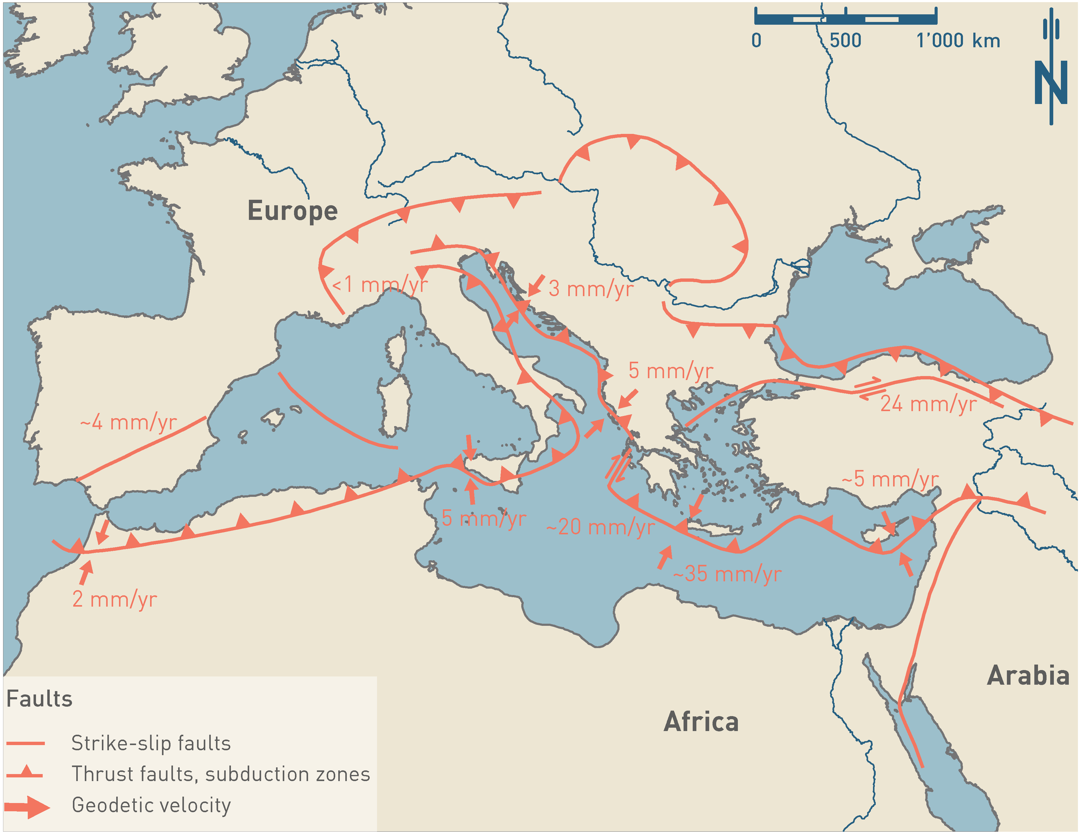
Fig. 3‑12:Present-day geodetic movements relative to Eurasia
For detailed present-day geodetic velocities, see Section 6.2.
Geodetic velocities are taken from Nocquet (2012). The plate boundaries are modified after Pfiffner (2009).