
At the beginning of the Triassic Period, the relief formed during the Variscan orogeny was mostly eroded to form a peneplain. At that time, Northern Switzerland was part of the Central European Basin, separated from the Neotethys by the Vindelician – Bohemian Massif and the Alemannic Land (Fig. 3‑5b). Possible synsedimentary tectonics related to rifting are inferred to have given rise to variations in sediment thickness, observed along the bounding faults of the Konstanz – Frick Trough (Birkhäuser et al. 2001, Diebold et al. 1991, Pietsch et al. 2023).
During the Early to Middle Triassic, terrestrial and subordinately coastal sediments were deposited in an extensive intracontinental basin (Buntsandstein Group, Dinkelberg Formation). Fluvial systems sourced mostly from the west deposited a succession of fine- to coarse-grained sandstone and some clay-mineral-rich beds (Wurster 1968). Several phases of fluvial accumulation were followed by phases of pedogenesis.
The overlying Middle Triassic succession (Muschelkalk Group) preserves 3 depositional phases:
-
The first phase (Lower Muschelkalk Group, Kaiseraugst Formation) was deposited during a period of marine transgression. At this time, a succession of silt- and sandstone with wave ripples, crossbedding and bioclastic calcareous beds were deposited in sublittoral and beach settings, passing up into a shallow marine environment. These are overlain by silty claystone and argillaceous marl with silty to fine sandy and bioclastic beds which were deposited during a period of intermittent sea-level rise. These are, in turn, overlain by dolomitic marl, evaporitic beds and some sandy and calcareous beds which were deposited in an intertidal to lagoonal environment recording a subsequent regression.
-
These are overlain by a second depositional phase (Middle Muschelkalk Group, Zeglingen Formation) recording a period of significant regression and emergence (Dronkert et al. 1990, Pietsch et al. 2023). Deposition took place in lagoons, ephemeral ponds, salina and intertidal to supratidal areas attesting to arid conditions and records a number of shallowing-upward sedimentary cycles (Pietsch et al. 2023). These cycles comprise successions of dolostone, marl, claystone, anhydrite and partly halite. Some of the halite was subsequently dissolved syn- to mesogenetically during the Middle Triassic, leading to the formation of dissolution breccias.
-
The third phase of Middle Triassic deposition (Upper Muschelkalk Group, Schinznach Formation) records two subsequent marine transgressions and regressions (Pietsch et al. 2016, Adams & Diamond 2019). At this time, a temporarily open marine seaway was established, connecting the Central European Basin with the Neotethys. Deposition of micrite with scattered, locally oolitic, bioclastic beds took place in a shallow marine environment during a transgression and regression. During later diagenesis, the sediments were partially or completely dolomitised and, in bioclastic or oolitic beds, some open porosity developed (Stamberg Member). This phase ends with the deposition of fossiliferous claystone and dolostone in a littoral, deltaic to brackish environment during a subsequent transgression and start of a regression.
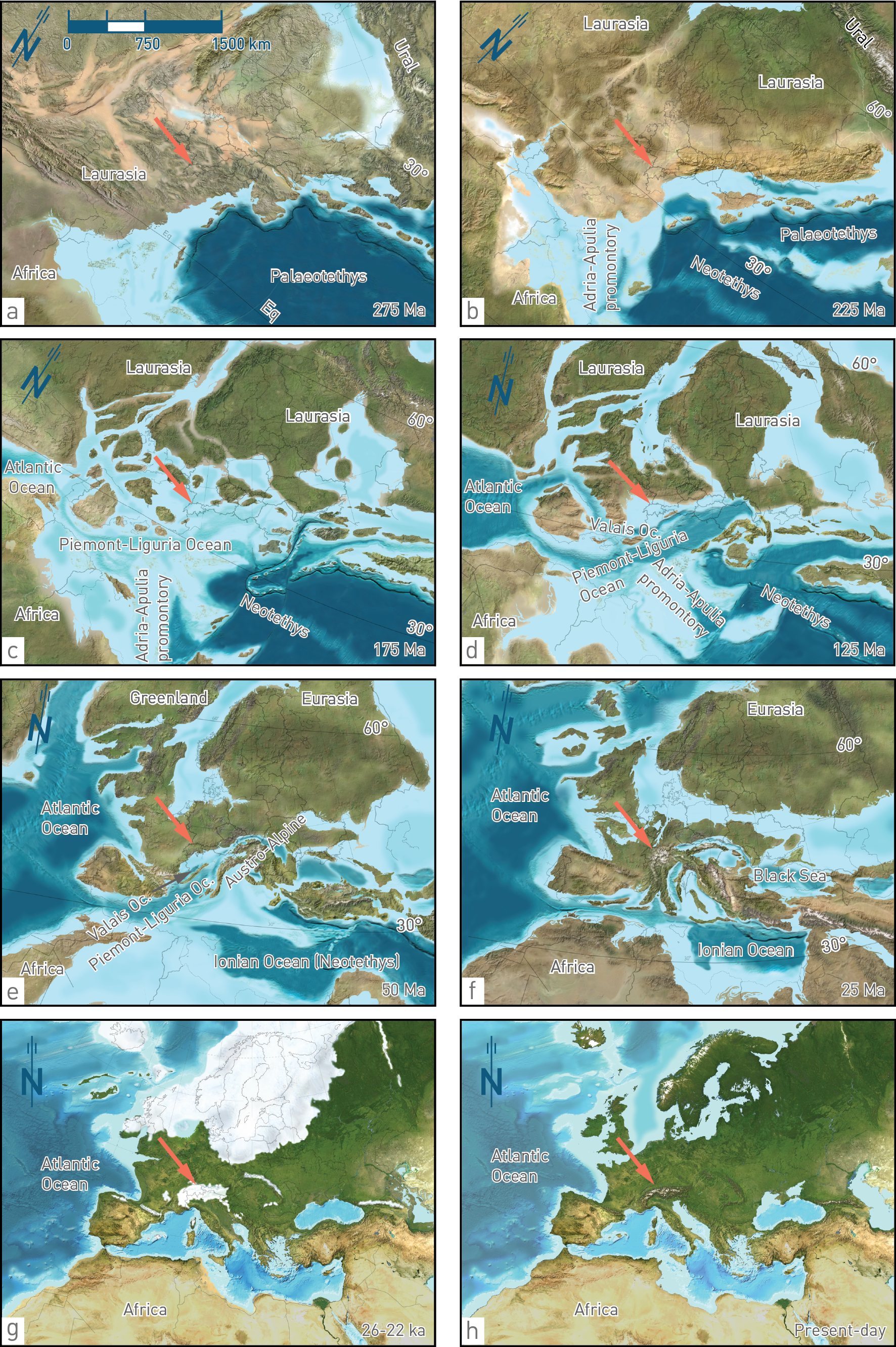
Fig. 3‑5:Palaeogeographic reconstruction showing Switzerland in the larger context
Modified after Palaeogeography of Europe ©2012 Colorado Plateau Geosystems Inc. The sediments of the following lithostratigraphic units were deposited during the presented time periods in Northern Switzerland: (a) Weitenau Formation, (b) Klettgau Formation, (c) Staffelegg Formation, (d) no sedimentary rocks preserved, (e) Siderolithic Group, (f) Lower Freshwater Molasse Group (USM), (g) Niederterrasse and (h) recent sediments.
Red arrows indicate the approximate location of Northern Switzerland. Eq: Equator; Oc.: Ocean.
Deposition at the southern extension of the Central European Basin during the Middle to Late Triassic (Keuper Group, Bänkerjoch Formation) took place during continued regression. At this time, terrestrial sediments were deposited in sabkha plains and comprised partly cyclic successions of chicken-wire anhydrite overlain by dolomitic claystone with thin anhydritic layers, in turn succeeded by claystone (Dronkert et al. 1990). The basin was influenced by sporadic marine incursions and deposition of dolomitic and sandy interlayers.
The Late Triassic succession (Keuper Group, Klettgau Formation; Fig. 3‑5b) was deposited in a largely terrestrial environment. As a result, sedimentary facies and thicknesses are highly variable, which is reflected in the heterogeneous Keuper aquifer in the three siting regions (Fig. 3‑3). Siliciclastic sediments were transported by rivers from the southern Norwegian Caledonides (Paul et al. 2008) and later from the Vindelician – Bohemian Massif and deposited on a continental playa under (semi)arid conditions (Fig. 3‑7; Jordan et al. 2016b). Deposits include sandstone-dominated fluvial channels and dolomitic marl-dominated floodplains, sometimes with pedogenic overprint. In the area of today’s Zürich Nordost (ZNO) siting region, porous dolomitic breccias were also deposited on the continental playa. Additionally, an intermediate marine transgression, from the southwest (Burgundy Gate) resulted in deposition of partly porous and bioclastic dolostone in the Jura Ost (JO) and Nördlich Lägern (NL) siting regions, and anhydrite in a shallow marine to coastal environment in ZNO. The youngest Triassic succession was also affected by two major erosional events, the Old Cimmerian and the Base Jurassic unconformities. As a result of the latter, Rhaetian sediments are completely absent over large areas.
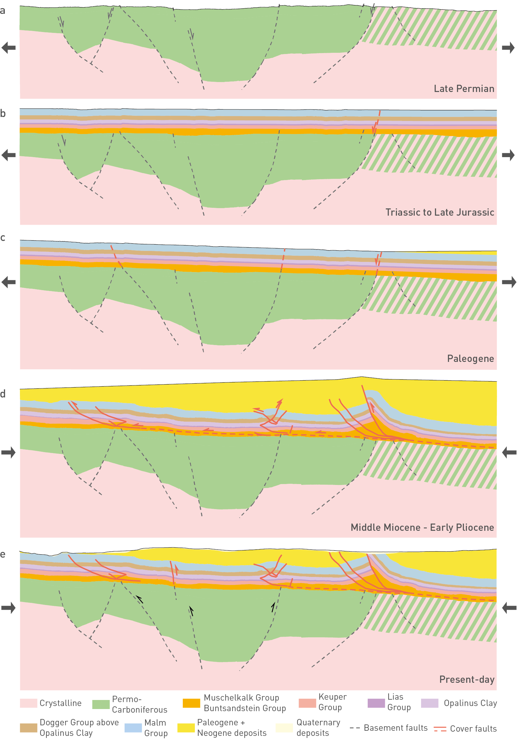
Fig. 3‑6:Geological evolution of the study area demonstrated on a schematic NNW-SSE cross-section
Black arrows are tentative indications for whether the time step was extension- or contraction-dominated. Green hatched zone reflects zone with Permo-Carboniferous or crystalline rocks.
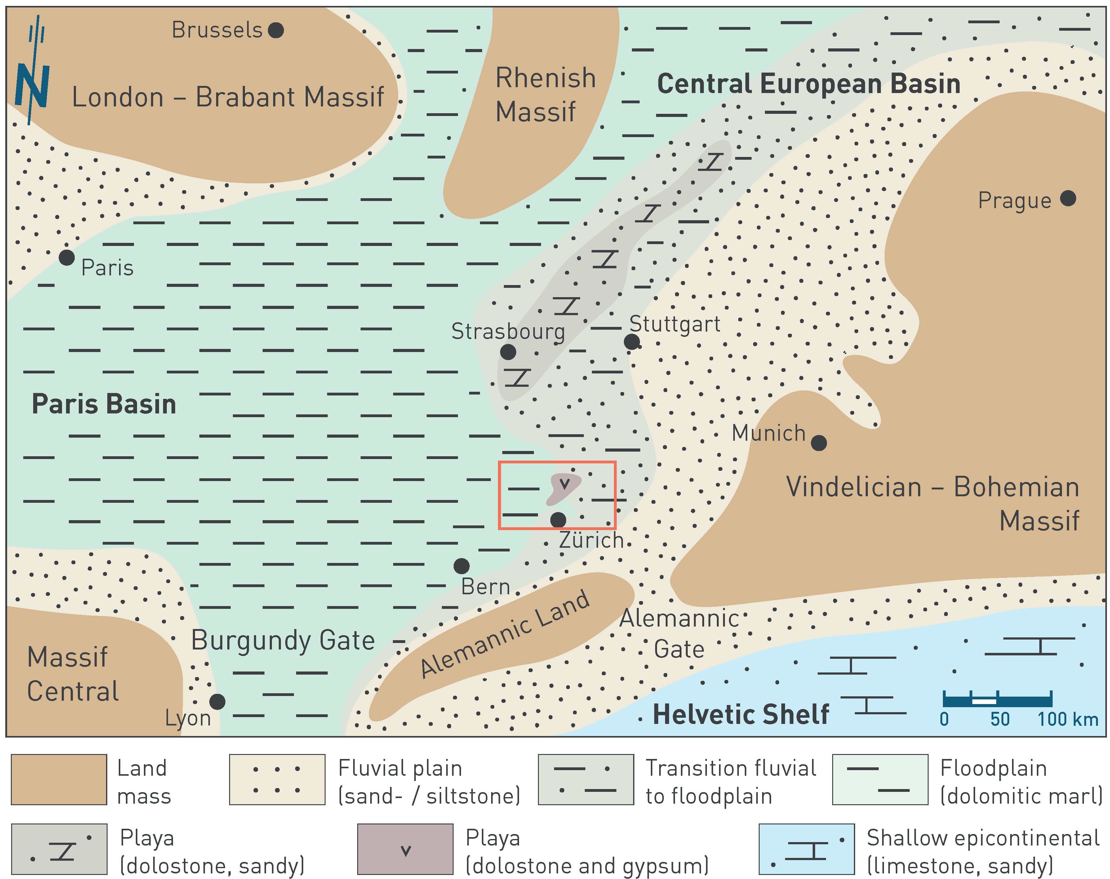
Fig. 3‑7:Palaeogeographic situation of Western to Central Europe in the Norian during the sedimentation of the Klettgau Formation (Seebi Member) and its time equivalents
The red rectangle shows the extent of the detailed palaeoenvironment maps (Section 4.2). Maps based on Geyer et al. (2023), Hagdorn & Nitsch (2009) and Pozsgai et al. (2017). The north arrow refers to present-day geographic north. The approximate locations of the cities are shown to simplify orientation.