
1. Introduction (NTB 24-17)
Key points:
- The present report synthesises the geological information for repository site selection and for the demonstration of post-closure safety.
- Repository safety is ensured by a multi-barrier system including engineered and geological barriers. The geological barrier isolates the waste from humans and the environment, ensures immobilisation, retention and slow release of radionuclides and contributes to the long-term stability of the repository system.
- The site selection process in Switzerland considers 13 criteria addressing long-term safety and construction feasibility. The final stage of the site selection process evaluates three remaining siting regions, all located in Northern Switzerland, an area with an overall low geodynamic activity and tectonic complexity and containing the host rock Opalinus Clay at a suitable depth and tectonic configuration.
- Key geological information provided for the general licence application includes (1) a detailed characterisation of the host rock and low-permeability confining units, (2) independent evidence for the barrier function over long timescales, (3) a detailed tectonic characterisation and (4) an assessment of the future geological evolution (geodynamics, climate, erosion) and its effects on the geological barrier.
In Switzerland, legal regulations (Nuclear Energy Act, KEG 2003 and Nuclear Energy Ordinance, KEV 2004) and guidelines are in place for the management of radioactive waste. The Nuclear Energy Ordinance (KEV) classifies Switzerland’s radioactive waste into low- and intermediate-level waste (L/ILW), alpha-toxic waste3 and high-level waste (HLW), the latter comprising spent fuel and vitrified HLW from reprocessing. The Nuclear Energy Act (KEG) requires the disposal of all these types of radioactive waste in deep geological repositories. The feasibility of this disposal solution has been demonstrated for L/ILW in Nagra (1985) and for HLW (including long-lived intermediate-level waste) in Nagra (2002).
The Sectoral Plan for Deep Geological Repositories (SGT) regulates the search for suitable siting regions for deep geological repositories in Switzerland. This site selection process is conducted in three stages (SFOE 2008). SGT Stages 1 and 2 have been completed and Stage 3 is currently ongoing. Clarifications of the safety-related specifications for this stage are provided in ENSI 33/649 (ENSI 2018), while ENSI Guideline G03 (ENSI 2023) and the corresponding explanatory report (ENSI 2020) specify the protection objective, protection criteria and design principles for the deep geological repositories.
In SGT Stage 3, three siting regions in Northern Switzerland have been investigated – Jura Ost (JO), Nördlich Lägern (NL) and Zürich Nordost (ZNO) – with the objective of selecting one siting region for a HLW repository, one for a L/ILW repository, or one for a combined repository for all waste types. Following a comparison of these siting regions, Nagra concluded that NL is the safest and most flexible siting region and is therefore applying for a general licence for a combined repository for both HLW and L/ILW at the Haberstal site within the region (Nagra 2022).
The justification for selection of a site, as well as the demonstration of post-closure safety at the site, are key components of the general licence application (RBG4). Fig. 1‑1 shows the post-closure safety and site selection reports that provide the underpinning evidence and assessment for the general licence application. From the top level downwards, they comprise:
-
The overarching safety report NTB 24-01 ("Sicherheitsbericht"; Nagra 2025b) which summarises the safety-related argumentation, including post-closure and operational safety shown at the top of Fig. 1‑1).
-
The upper left side of Fig. 1‑1 shows the reports supporting Nagra’s site comparison. The available options are compared with respect to safety and engineering feasibility and the results are synthesised in NTB 24-03 ("Bericht zur Begründung der Standortwahl"; Nagra 2025a).
-
The upper right side of Fig. 1‑1 shows the reports documenting the post-closure safety case for the combined repository at the site, including its synthesis in NTB 24-10 ("Post-Closure Safety Report"; Nagra 2024r).
-
The central part of Fig. 1‑1 shows a report presenting the safety and repository concept, including the provisional design.
The lower part of Fig. 1‑1 shows a selection of geological reports providing the scientific basis for the relevant aspects of the geological barrier and its future evolution. The present report, NTB 24-17 ("Geosynthesis") essentially synthesises the geological information presented in the lower-level geological reports.
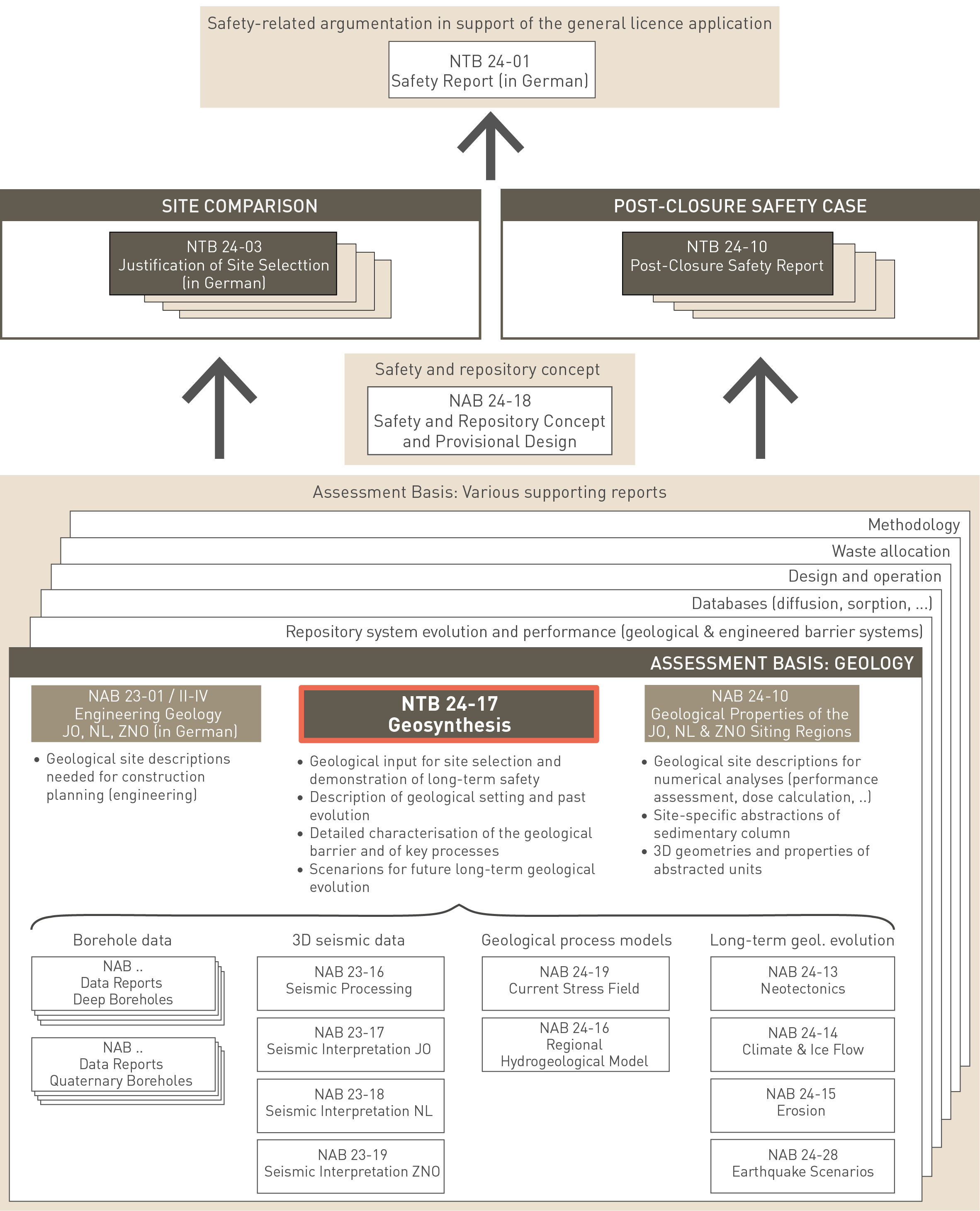
Fig. 1‑1:Positioning of this report, NTB 24-17 ("Geosynthesis"), in relation to key reports for site selection and demonstration of post-closure safety and to supplementary geological reports
This geosynthesis provides the geological basis for comparing the three siting regions JO, NL and ZNO, selected for further evaluation as a repository site in SGT Stage 3 based on a defined set of safety-based criteria (Nagra 2025a and references therein; Fig. 1‑2). The report sets out the geological basis for demonstrating post-closure safety for the proposed site (Nagra 2024r) and references therein). Specifically, the report describes the current geological situation in Northern Switzerland and its past evolution with an emphasis on the rock formations that form the geological barrier of the planned repository. Particular emphasis is placed on the geological properties and processes relevant for the long-term stability of the barrier. As well as describing the current geological situation, the report presents scenarios of the natural processes that could affect the barrier or modify its geological environment over the next one million years, that is the time period under consideration for the high-level waste repository (HLW; Nagra 2024r). The scenarios are based on a detailed reconstruction of geological history and related processes. To ensure a robust geological argumentation, key findings relevant to site selection and safety draw on multiple lines of arguments and different, independent methodologies.
This geosynthesis is the central document integrating the geological knowledge base for site comparison and demonstration of long-term safety. It is complemented by two further reports addressing specific user groups (Fig. 1‑1):
-
NAB 24-10 (Nagra 2024m) provides quantitative geological descriptions of the three sites in relation to repository performance assessment (Nagra 2024v) and dose calculations (Nagra 2024u). It documents how the sedimentary column is divided into geological units with similar properties, presents the 3D geometry of these units in the relevant area of the siting regions and suggests unit-specific parameter ranges for key properties.
-
NAB 23-01 / Volumes 2 – 4 (Nagra 2023a, Nagra 2023b, Nagra 2023c) contains the engineering geological characterisation of the three siting regions with regard to construction planning and construction risk analyses.
In contrast to earlier geosynthesis reports (e.g. Nagra 2002), this report only addresses the relevant natural processes and their effect on the geological barrier. The interactions between waste inventory, engineered barriers and the near-repository geological barrier (repository-induced effects) are treated in the performance assessment reports (Nagra 2024v and references therein), including the parametrisation of the excavation damaged zone and gas transport through the geological barrier.
The reports and scientific papers forming the underpinning knowledge base upon which this geosynthesis is predicated are cited in the present document. A selection of Nagra reports detailing the geological findings of the investigations undertaken in SGT Stage 3 is shown in Fig. 1‑1.
The report is organised as follows:
-
Chapter 1 introduces the function and key characteristics of the geological barrier with regard to long-term safety and site selection. It also summarises why the final stage of site selection focuses on three regions in Northern Switzerland.
-
Chapter 2 gives an overview of the geological knowledge base supporting this report, with a special focus on the detailed site investigations carried out in the third and final phase of the site selection process (SGT Stage 3).
-
Chapter 3 summarises the regional geological evolution and natural tectonic and climatic processes in the past with a view to understanding the geological barrier as it exists today, as well as its future evolution.
-
In Chapter 4 the present-day geological situation in the siting regions is described in detail, with emphasis on the similarities and differences between the regions.
-
Chapter 5 focuses on the host rock and the adjacent low-permeability confining units, with a focus on barrier properties and processes ensuring their long-term stability.
-
In Chapter 6 scenarios for future geological evolution are developed. These focus on the next one million years and include climate, tectonic and erosion scenarios. Their effects on the geological barrier are discussed.
-
Chapter 7 summarises the most important geological findings with regard to site comparison and long-term safety.
Depending on background and interests, the reader may choose different ways to read the report. Besides the classical way of reading a report from front to back or studying specific chapters based on the table of contents, the report structure offers two alternative approaches:
-
Track the scientific basis supporting the key geological outcomes for the demonstration of long-term safety and site comparison: Start with the 3-page text summarising the ‘Key outcomes for the demonstration of long-term safety and site comparison’ at the very beginning of the report (English and German versions available). For each statement you will be guided directly to chapters and sections of the report containing the background information necessary to understand and trace the arguments.
-
Track the evolution of the database and the key findings in SGT Stage 3 compared to earlier reference studies: Readers who are familiar with past investigation phases and the corresponding geological documentation may start reading with Section 7.1. This section summarises the evolution of the geological database and the related key findings since the demonstration of disposal feasibility for HLW (Entsorgungsnachweis; Nagra 2002) and since the submission of the documentation for Stage 2 of the Sectoral Plan (Nagra 2014h). For each listed bullet point, links to the sections setting out the current state of knowledge are given.
The report describes geological features and processes in varying levels of detail. This is intentional and, for the most part, reflects their importance for safety-relevant aspects or its scientific complexity. Where concepts are not described in the report, to keep the report as succinct as possible, the reader is referred to where further information describing the concept can be accessed.
In line with the Swiss legal and regulatory framework as well as national and international principles and practices, the deep geological repository provides safety by means of multiple geological and engineered barriers, i.e. a multi-barrier system (Nagra 2024r).
Regarding post-closure safety, the geological barrier has to provide the following functions (Nagra 2024r):
-
Isolation of radioactive waste from humans and the environment
-
Immobilisation, retention and slow release of radionuclides
-
Contribution to the stability of the repository system with regard to long-term geological and climate evolution
Furthermore, the geological and the engineered barriers must be compatible. This means that the conditions in the host rock should not influence the long-term stability of the engineered barriers in a critical way and the engineered barrier system should not adversely affect the natural barrier afforded by the host rock.
For the three siting regions, the Opalinus Clay host rock provides the primary geological barrier characterised by excellent barrier properties mainly attributed to its high clay-mineral content. The repository will be constructed in this roughly 100 m thick unit. Directly above and below the Opalinus Clay, low-permeability confining units with a partially lower and more heterogeneous clay-mineral content, further contribute to the retardation and slow transport of radionuclides.
The Opalinus Clay host rock and adjacent overlying and underlying low-permeability confining units comprise the containment-providing rock zone (CRZ)5. The safety concept requires the CRZ to be located at sufficient depth over the period under consideration to limit any detrimental impact of surface processes, such as erosion, on the safety-related properties of the Opalinus Clay itself and its confining units.
Note that ‘CRZ’ is an established term that is used for safety assessment and site comparison. In Chapters 2 – 7 of this report, instead of ‘CRZ’ we generally use the corresponding, but more geological description ‘host rock and low-permeability confining units’. See Fig. 4‑140 for site-specific delimitations of the confining units. ↩
In Switzerland, a formal site selection process was put in place by the federal government to identify the most suitable geological situation for the deep geological repository (SFOE 2008). The Sectoral Plan for Deep Geological Repositories (SGT) defines 13 site selection criteria addressing long-term safety and engineering suitability (Fig. 1‑2), grouped as follows:
-
Group 1 criteria mainly consider the geometry and safety-relevant properties of the CRZ including the geochemical conditions in the host rock relevant for the stability of the engineered barriers. The assessment of the hydrogeological situation at the sites considers independent evidence for slow transport (e.g. porewater composition, hydraulic heads, groundwater residence times in neighbouring aquifers).
-
Group 2 is concerned with the evolution of the CRZ during the period under consideration (up to 100'000 years for L/ILW and up to one million years for HLW), specifically to consider the effects of geodynamic, climatic and erosional long-term processes, repository-induced effects and human actions.
-
Group 3 addresses uncertainties originating from limitations on the level to which it is possible to characterise the geological barrier and extrapolate understanding as well as to predict its long-term evolution.
-
Group 4 criteria assess the constructability of the repository in the host rock and the access infrastructure through the overlying strata at each site.
The SGT (SFOE 2008) requires site selection in Switzerland to be staged, based on a safety-based site comparison. The first of the three stages comprised a nationwide screening process for suitable host rocks and siting regions, resulting in the identification of six siting regions and three potential host rocks. Further investigations in Stage 2 selected the Opalinus Clay as the only host rock to be further investigated. This stage also selected three of the six siting regions to be taken forward for detailed investigations in Stage 3, the final stage. These three siting regions, JO, NL and ZNO, are located in Northern Switzerland. Section 1.5 presents the main arguments favouring these regions.
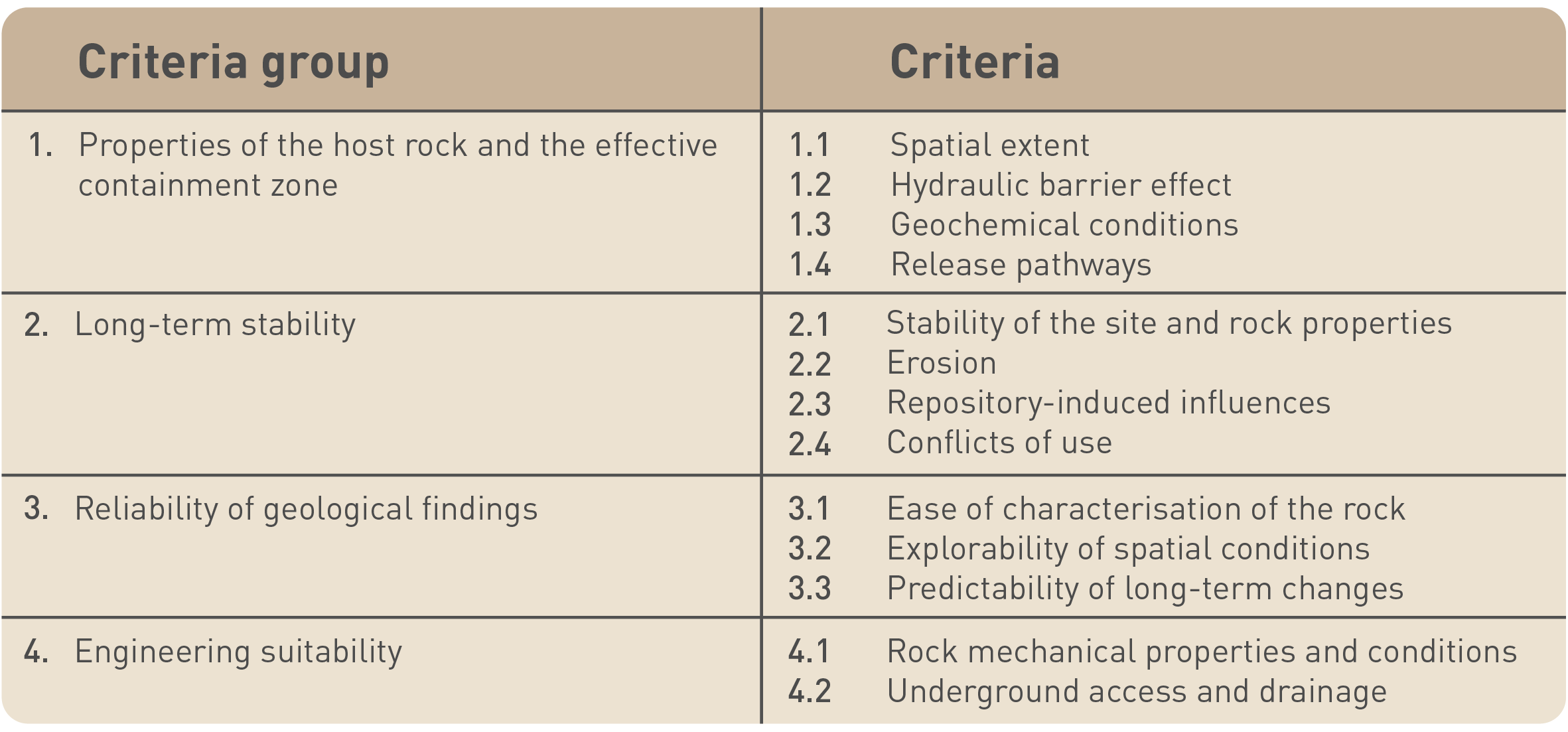
Fig. 1‑2:Criteria to be used for site selection (SFOE 2008)
The site comparison process in SGT Stage 3 includes the following key steps (see Nagra 2025a for a full description with links to the regulatory guidelines):
-
Definition of the potential disposal zone and delineation of the CRZ with spatial reserves:
All three siting regions have potential disposal zones in the Opalinus Clay with large lateral extents that far exceed the spatial requirements according to the current repository design. Key factors determining the lateral extent of the potential disposal zone are (1) the avoidance of regional tectonic elements and larger tectonic faults and (2) the choice of an overall suitable minimum depth of the host rock with respect to future erosion.
For the site comparison, CRZs were defined with lateral dimensions considerably smaller compared to the potential disposal zone. These fulfil a standardised lateral spatial requirement (2 km2 and 1.2 km2 for HLW and L/ILW, respectively). CRZs with spatial reserves include a multiple of this (6 km2 and 3.6 km2 for HLW and L/ILW, respectively). Vertically, the CRZ includes the host rock and the surrounding low-permeability confining units. The delineation of the CRZ and spatial reserves requires a detailed geological and hydrogeological characterisation of the geological units above and below the host rock and a well-known host rock geometry and local fault pattern in the area of the potential disposal zone.
-
Definition of provisional site-specific repository designs as the basis for quantitative safety analyses and qualitative evaluation:
The delineation of these elements considers the local geological conditions (particularly the host rock geometry and the location of local faults) and further construction and operation requirements.
-
Quantitative safety analyses for site comparison:
Each site-specific safety analysis evaluates radionuclide release rates to the surface environment as a function of time for a defined set of safety scenarios. The dose calculations consider the site-specific geological description and the parametrisation of the CRZ, with particular emphasis on the thickness of subunits with similar characteristics, their transport properties and the hydraulic gradients6.
-
Qualitative evaluation of the CRZ according to the 13 criteria for safety and engineering feasibility defined in the SGT (Fig. 1‑2):
This evaluation requires a detailed geological description of the host rock and the confining units, including independent evidence documenting the efficiency of the CRZ as a transport barrier over the relevant timescales. Furthermore, a description of the local fault pattern in the context of the regional tectonic situation is required. The evaluation of the long-term stability of the geological barrier requires scenarios for the geodynamic, climatic and erosional evolution of the sites and their effects on the geological barrier. The descriptions should address the uncertainties regarding the current state of the geological barrier and its future evolution. Finally, the engineering geological basis for the construction risk evaluation of the underground repository and the access infrastructure needs to be provided7.
-
Overall comparative safety evaluation:
The overall comparative safety evaluation and site selection combines the steps introduced above. For further information and final outcomes, see Nagra (2025a).
According to ENSI (2018), the geological investigations in SGT Stage 3 must provide the level of site-specific knowledge required to evaluate the 13 safety criteria, undertake a comparative safety analysis for the siting regions, and develop a safety case for the proposed site with robust and well evidenced arguments. Based on the considerations summarised in Sections 1.4.1 and 1.4.2, the geological investigations should therefore provide the underpinning evidence and argumentation base to support the demonstration of the following required characteristics:
-
The host rock provides the primary geological containment function and is a particularly efficient and robust transport barrier. This requires a sufficiently thick host rock, limited llithological and mineralogical variability, very low hydraulic conductivities, low hydraulic gradients, a lack of distinct transport paths and thus diffusion-dominated transport conditions. Furthermore, the mineralogical composition and the related pore structure should favour the sorption of radionuclides and the geochemical conditions needed to promote the stability of the engineered barriers.
-
Low-permeability confining units above and below the host rock contribute to the barrier effect. Compared to the host rock, the properties of the confining units may show a higher variability (e.g. concerning the clay-mineral content), but, as a whole, the CRZ should be characterised by low hydraulic conductivities, and transport should be diffusion-dominated.
-
The efficiency of the geological barrier over long timescales is independently evidenced.
-
The host rock occurs in a simple, subhorizontal to slightly inclined bedding configuration wherby areas devoid of seismically mappable faults should be as large as posible, providing flexibility for repository placement and design.
-
The key properties of the host rock remain stable over the period under consideration with regard to long-term geological evolution. This requires that porewater composition, hydraulic conductivity, self-sealing capacity and diffusion coefficients in the CRZ do not change in a detrimental way in response to natural processes that may be active during the next 100'000 to 1 million years. This includes climate change, glacial loading and unloading, erosion, geodynamic activity or rock dissolution phenomena. The depth of the host rock and the lateral distance to regional tectonic fault systems are pivotal considerations for long-term stability.
The points above address the geological barrier and its contribution to post-closure safety. In addition, geological investigations will provide the basis for the construction risk engineering analyses in the three siting regions as well as for planning the provisional engineering design of the repository at the proposed site8.
The investigation campaign described in Chapter 2 focused on the provision of the data and information to support assessment of the required characteristics in line with the regulatory requirements (ENSI 2018).
Note that the engineering geological characterisation for construction-related issues is given in separate reports (Nagra 2023a; 2023b; 2023c). ↩
The emphasis on Northern Switzerland as the preferred area for the location of a deep geological repository is the result of a systematic approach followed during SGT Stages 1 and 2 consisting of a stepwise narrowing-down process, starting from an investigation of all of Switzerland (SFOE 2008, Nagra 2008a, 2014i).
Northern Switzerland possessed the following positive attributes for siting a deep geological repository (Fig. 1‑3):
-
Low geological complexity: The siting regions are located outside large-scale tectonically complex zones, namely the Alps and the internal Jura, as well as the European Cenozoic Rift System (Upper Rhine Graben and its eastern border zone) and the related conjugated smaller Bonndorf – Hegau – Bodensee Graben system.
-
Low recent tectonic activity: The siting regions are located away from areas with enhanced historically or instrumentally documented seismic activity, namely the Valais, Graubünden, the Prealps and the Basel areas.
-
Low uplift rates: The siting regions are situated in the external Alpine Foreland characterised by low uplift rates compared to areas further south (Alps and internal Alpine Foreland).
-
Host rock with favourable properties at suitable depth and tectonic configuration: Based on a systematic screening of potential host rocks throughout the country (Nagra 2008b), the Opalinus Clay proved to be best suited on the basis of its extremely low permeability and high lateral continuity. In Northern Switzerland, the Opalinus Clay is around 100 m thick and occurs in a depth window between 400 m and 1'000 m, suitable with regard to both long-term stability (protection against future erosion) and repository construction.
In the JO, NL and ZNO siting regions, the Opalinus Clay occurs in subhorizontal to slightly inclined bedding configurations distal to regional fault zones.
Other candidate host rocks and regions were systematically evaluated earlier in the siting process but were excluded from further consideration because they were deemed less suitable for hosting a deep geological repository (e.g. unfavourable host-rock properties, insufficient thickness or lateral extent; see Nagra 2008b and 2014h for details).
Fig. 1‑3:Key aspects used for selecting the location of the Jura Ost (JO), Nördlich Lägern (NL) and Zürich Nordost (ZNO) siting regions in Northern Switzerland
(a) Earthquake catalogue of Switzerland (Fäh et al. 2011, update 30.09.2023) and probability map for earthquakes with magnitude Mw ≥ 6 at 0 – 15 km depth in an area of 0.05° longitude × 0.05° latitude (~ 21 km2) based on expert elicitation (swissnuclear 2013). (b) Uplift rates derived from high-precision levelling data (based on Schlatter 2014). The movements are shown relative to a reference point located in Laufenburg. (c) Tectonic map of Switzerland (Swisstopo 2005 modified). (d) Depth of Top Opalinus Clay in the Swiss Molasse Basin and adjacent areas (based on the Nagra regional geological model and GeoMol; Allenbach et al. 2017).