
The emphasis on Northern Switzerland as the preferred area for the location of a deep geological repository is the result of a systematic approach followed during SGT Stages 1 and 2 consisting of a stepwise narrowing-down process, starting from an investigation of all of Switzerland (SFOE 2008, Nagra 2008a, 2014i).
Northern Switzerland possessed the following positive attributes for siting a deep geological repository (Fig. 1‑3):
-
Low geological complexity: The siting regions are located outside large-scale tectonically complex zones, namely the Alps and the internal Jura, as well as the European Cenozoic Rift System (Upper Rhine Graben and its eastern border zone) and the related conjugated smaller Bonndorf – Hegau – Bodensee Graben system.
-
Low recent tectonic activity: The siting regions are located away from areas with enhanced historically or instrumentally documented seismic activity, namely the Valais, Graubünden, the Prealps and the Basel areas.
-
Low uplift rates: The siting regions are situated in the external Alpine Foreland characterised by low uplift rates compared to areas further south (Alps and internal Alpine Foreland).
-
Host rock with favourable properties at suitable depth and tectonic configuration: Based on a systematic screening of potential host rocks throughout the country (Nagra 2008b), the Opalinus Clay proved to be best suited on the basis of its extremely low permeability and high lateral continuity. In Northern Switzerland, the Opalinus Clay is around 100 m thick and occurs in a depth window between 400 m and 1'000 m, suitable with regard to both long-term stability (protection against future erosion) and repository construction.
In the JO, NL and ZNO siting regions, the Opalinus Clay occurs in subhorizontal to slightly inclined bedding configurations distal to regional fault zones.
Other candidate host rocks and regions were systematically evaluated earlier in the siting process but were excluded from further consideration because they were deemed less suitable for hosting a deep geological repository (e.g. unfavourable host-rock properties, insufficient thickness or lateral extent; see Nagra 2008b and 2014h for details).
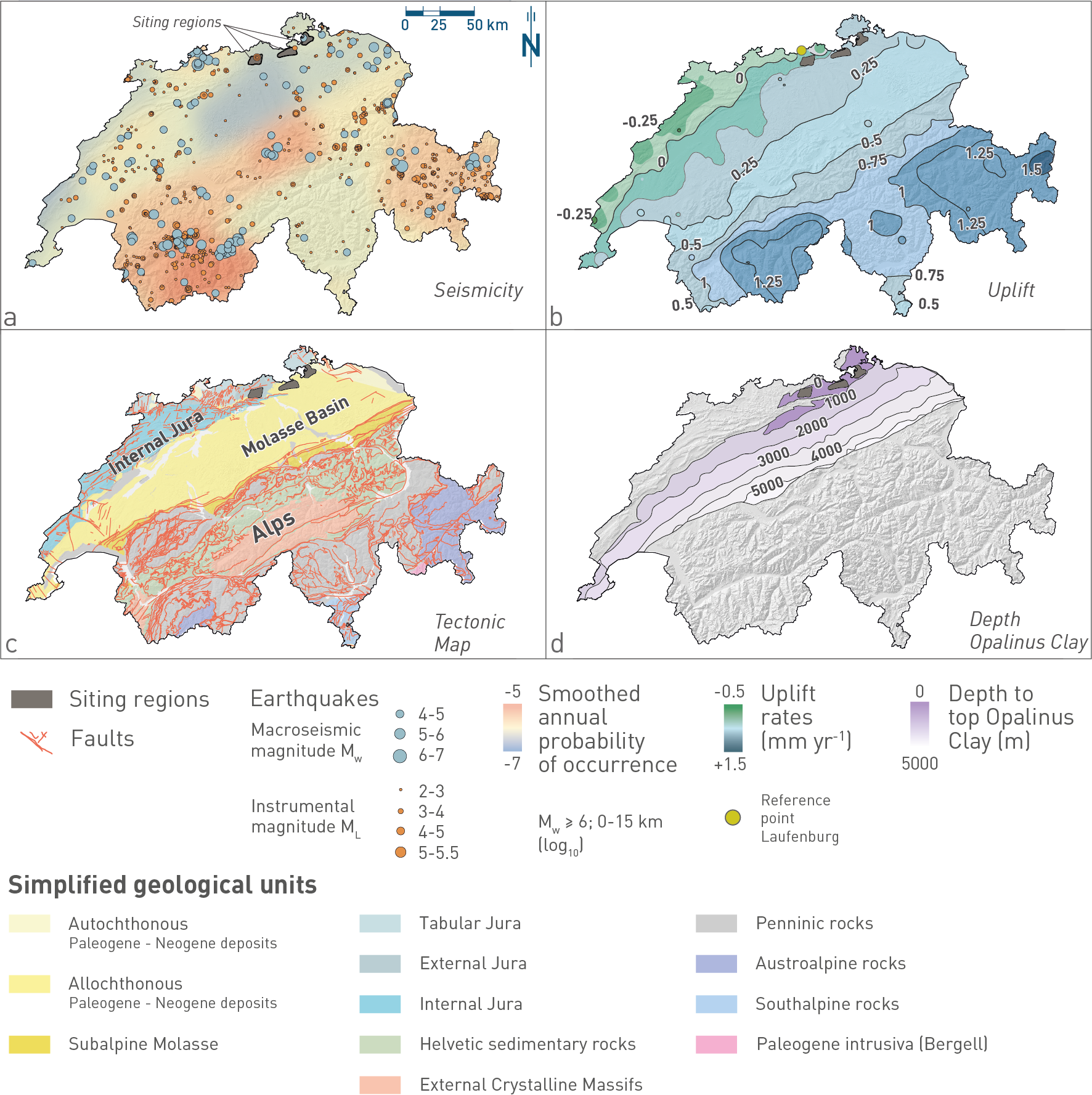
Fig. 1‑3:Key aspects used for selecting the location of the Jura Ost (JO), Nördlich Lägern (NL) and Zürich Nordost (ZNO) siting regions in Northern Switzerland
(a) Earthquake catalogue of Switzerland (Fäh et al. 2011, update 30.09.2023) and probability map for earthquakes with magnitude Mw ≥ 6 at 0 – 15 km depth in an area of 0.05° longitude × 0.05° latitude (~ 21 km2) based on expert elicitation (swissnuclear 2013). (b) Uplift rates derived from high-precision levelling data (based on Schlatter 2014). The movements are shown relative to a reference point located in Laufenburg. (c) Tectonic map of Switzerland (Swisstopo 2005 modified). (d) Depth of Top Opalinus Clay in the Swiss Molasse Basin and adjacent areas (based on the Nagra regional geological model and GeoMol; Allenbach et al. 2017).