
2. Overview of geological investigations with relevance for siting and demonstration of post-closure safety (NTB 24-17)
Key points:
- A comprehensive scientific field investigation programme was carried out to characterise the safety-relevant geological properties and processes in the three siting regions.
- 3D seismic datasets provide detailed information for determining the depth and thickness of the relevant geological units, the location of faults and lateral facies changes.
- Investigations in 9 deep boreholes included detailed core descriptions, petrophysical logging and an extensive in-situ hydrogeological and geomechanical test programme. Host rock, low-permeability confining units and bounding aquifers were almost continuously cored. A large range of laboratory tests allowed a detailed characterisation of the relevant rock properties.
- A dedicated field investigation programme focused on Quaternary deposits improved the understanding of the erosion history over the past 1 – 2 million years and provided input for the estimation of future erosion to assess the long-term stability of the repository.
- Data integration included knowledge and concepts derived from academic research, industry projects (hydrocarbon exploration, carbon capture and storage, geothermal energy) and from work carried out by other radioactive waste management organisations. The latter include investigations in underground rock laboratories.
This chapter provides an overview of the geological knowledge base of Northern Switzerland (Fig. 2‑1) with a special focus on the detailed site investigations carried out in the third and final stage of the site selection process (SGT Stage 3).
The geology of Northern Switzerland was intensively investigated prior to the start of the Sectoral Plan for Deep Geological Repositories (SGT) process in 2008, providing a well-established understanding of the subsurface and its geological evolution. The stratigraphic, tectonic and hydrogeological framework has been analysed since the middle of the 19th century through applied projects and academic research (e.g. Mösch 1867, Mühlberg 1901, Frei 1912, Amsler 1915, Buxtorf 1916, Heim & Hartmann 1919, Hartmann 1925, Schmassmann 1945, Laubscher 1961, Büchi et al. 1965, Hantke 1967). The intensive exploration campaigns carried out by Nagra in the 1980s (summarised in Thury et al. 1994) and in the 1990s (summarised in Nagra 2002), together with related scientific work (e.g. Matter & Peters 1987, Mazurek et al. 2006, Gimmi et al. 2007), significantly enhanced subsurface understanding of Northern Switzerland. Geophysical field work, together with participation in third-party drilling projects undertaken in the first two stages of the siting process (SGT Stage 1 and 2), further extended the knowledge base, and the integration of this new information improved process understanding (summarised in Nagra 2008b, 2014b). Swisstopo’s 1:25'000 scale geological maps and corresponding detailed explanatory notes (accessible via map.geo.admin.ch), and regional 3D models of key geological horizons and faults developed within the framework of the GeoMol project (Allenbach et al. 2017), supplement this understanding.
The site investigations conducted for the third stage of the siting process (SGT Stage 3) took place between 2015 and 2022. The aim was the characterisation of the key attributes for site selection and the demonstration of the long-term safety for the proposed site (see Section 1.4.3), as well as the demonstration of engineering feasibility. The initial planning of the investigations was summarised in site-specific exploration concepts (Nagra 2014a, 2016). The exploration plan was refined and adapted during the investigations, incorporating learnings as new data were acquired and experience gained. It was also ensured that the regulatory requirements for the geological site investigations (ENSI 2018) were met.
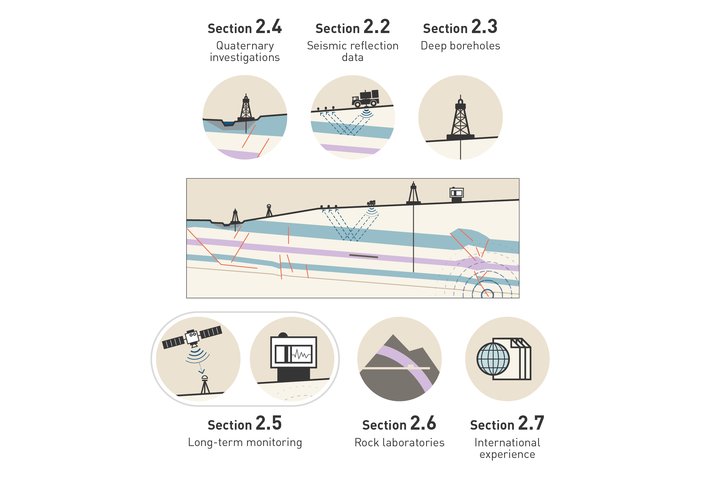
Fig. 2‑1:Schematic overview of important sources of information for the characterisation of the geological barrier
Note that the project also benefited from selected geological outcrop studies (not shown in the figure).
An overview of the most important data sources used to characterise the geological barrier and to evaluate its past and future evolution is provided below and illustrated in Fig. 2‑1. They include data arising from Nagra and third-party field investigations (seismic surveys, boreholes) as well as from decades of research in the Mont Terri rock laboratory. Seismic investigations (Section 2.2) provide 2D or 3D information on the geometry of the geological units and tectonic faults. This information is fundamental for siting a deep geological repository in a subhorizontal to slightly inclined host rock configuration with low deformation. Deep boreholes allow characterisation of the rocks and their properties and the calibration of seismic data (Section 2.3). A shallow investigation programme (shallow geophysics, shallow boreholes, outcrop analyses; Section 2.4) quantifying the processes and rates of the Quaternary geodynamic and erosional evolution provides the understanding necessary to assess the evolution of the geological barrier during the next one million years. Further input regarding future geological evolution is provided by long-term monitoring systems delivering, for example, information on recent seismicity and movements of the Earth’s surface (Section 2.5). Experiments in the Mont Terri rock laboratory hosted in the Opalinus Clay give further insights into key processes in the host rock (Section 2.6). Lastly, the project benefits from the general understanding of the behaviour of clay-rich rocks built up by applied and academic research (Section 2.7).
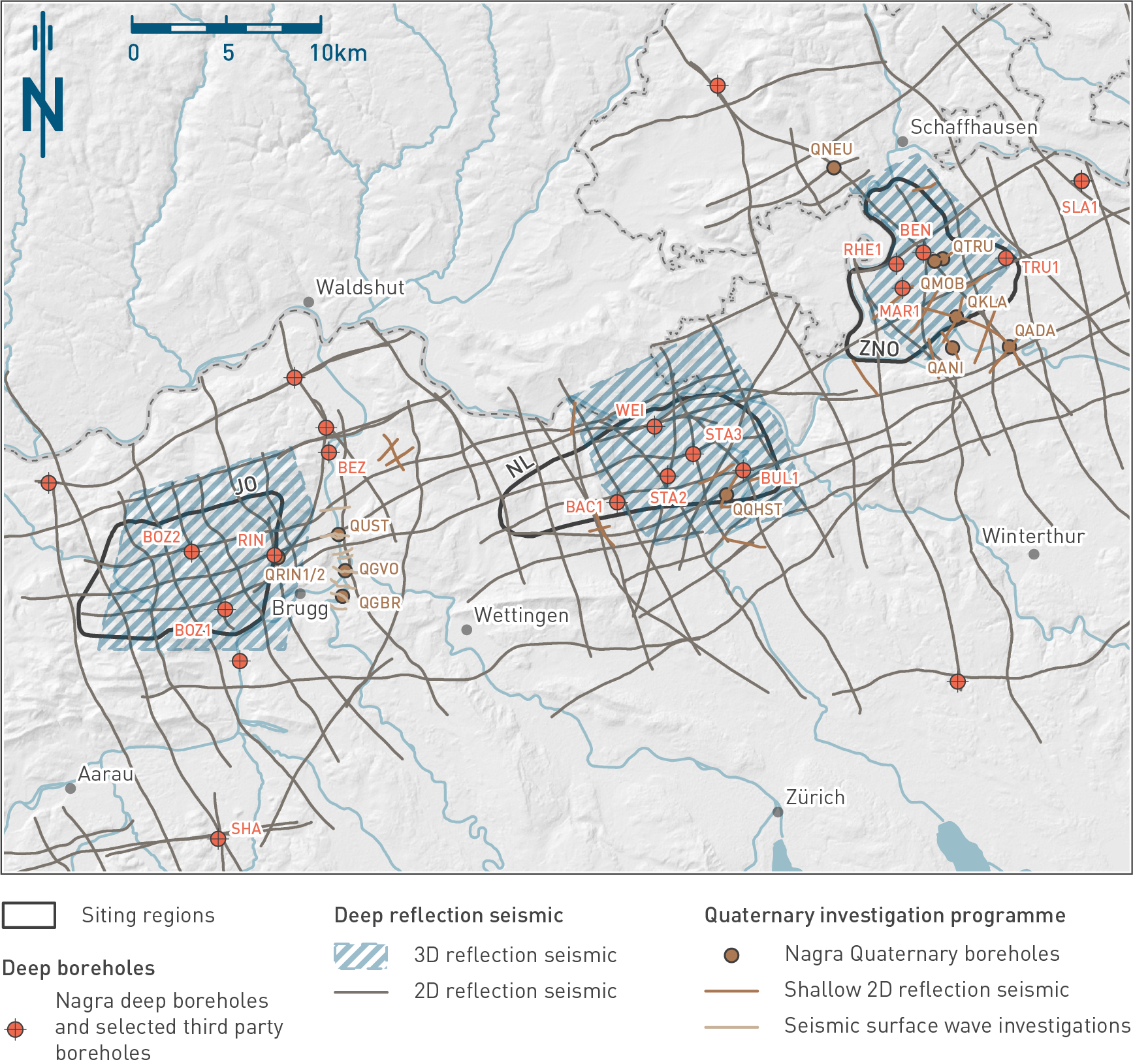
Fig. 2‑2:Important geophysical datasets and boreholes in Northern Switzerland
Boreholes discussed in this report are labelled. See Tab. 2‑1 (deep boreholes) and Tab. 2‑2 (Quaternary boreholes) for further information and references to data reports.
Northern Switzerland is covered by a dense grid of 2D seismic lines (Fig. 2‑2) acquired over several exploration campaigns from the early 1980s by Nagra and third parties (mainly the hydrocarbon exploration industry). In SGT Stage 2 the existing seismic data were reprocessed in a consistent way, and further complementary 2D seismic data were acquired to fill gaps in and around the siting regions. These lines of data, with a typical line spacing of 1 – 3 km, provided a robust understanding of the regional tectonic framework and elements as well as the depth and geometry of key Mesozoic units including the Opalinus Clay (Madritsch et al. 2013, Nagra 2014a, 2014b, Meier et al. 2014).
In conjunction with SGT Stage 3, Nagra acquired 3D seismic surveys in all three siting regions between 2015 and 2017 to provide a continuous and more comprehensive image of the subsurface necessary for site-scale geological characterisation. Part of the Zürich Nordost (ZNO) siting region had previously been covered by a 3D survey, acquired by Nagra in 1997 in connection with the demonstration of disposal feasibility for a HLW repository (Nagra 2001). To include areas with shallower Opalinus Clay potentially suited for a L/ILW repository, the existing survey in ZNO was extended to the north. The processing of the seismic data included data from both the original and the new acquisition, resulting in a merged continuous 3D dataset. The area covered by 3D seismic data in the three siting regions amounts to a total of 240 km2. The seismic processing is documented in Nagra (2024s) and the final interpretation in Nagra (2024a) for Jura Ost (JO), Nagra (2024b) for Nördlich Lägern (NL) and Nagra (2024c) for Zürich Nordost (ZNO).
The aims of the new surveys were 3D mapping of key geological horizons to provide detailed information on depth, thickness and inclination of relevant geological units, the distribution and geometry of faults, the identification of lateral facies changes and the reconstruction of the tectonic history. The survey design was informed by existing geological knowledge from Stage 2 of the Sectoral Plan, primarily 2D seismic data, outcrop information and a few deep boreholes (Madritsch et al. 2013, Nagra 2014b). The surveys primarily targeted the host rock and the confining units in the central areas with flat-lying little disturbed strata, but also provided information on the larger-scale tectonic elements in the surrounding regions. The processing of the seismic field data was optimised to support the comparison of the three siting regions for the purpose of the site selection (Nagra 2024s). The seismic imaging in the potential disposal zones in all the siting regions is of high quality, achieving the survey aims and providing the data necessary for site selection and the demonstration of post-closure safety. This, together with the systematic interpretation approach applying rigorous criteria (Nagra 2024a, 2024b, 2024c) ensures a high comparability of the interpretation results between the regions despite some differences in topography, geological setting and acquisition method.
A total of 9 new deep boreholes were drilled between 2019 and 2022. Together with the existing deep boreholes Riniken (RIN; JO), Weiach (WEI; NL) and Benken (BEN; ZNO), each of the three siting regions has between 3 and 5 deep boreholes, which were used for calibration and depth conversion of the 3D seismic data (Fig. 2‑2).
The main aims of the most recent drilling programme were the calibration of the 3D seismic data and the geological characterisation of the host rock and the adjacent low-permeability confining units (e.g. mineralogy, porosity, transport properties, geomechanical properties, hydraulic state, stress conditions; see Chapters 4 and 5). A further aim was to characterise the deep aquifers above and below the host rock and its low-permeability confining units as they define the boundary conditions for transport in the aquitard sequence and represent the most important hydraulic connection to the biosphere. The investigations of the deep aquifers included an assessment of hydraulic conductivities, hydraulic heads and the characterisation of the groundwater geochemistry and residence times.
In most of the boreholes, the bulk of the Mesozoic rock sequence and the uppermost part of the underlying Paleozoic rock was cored, providing information on the host rock, confining units, neighbouring aquifers and on the underlying evaporitic series, known to be relevant for tectonic evolution. One of the boreholes, RHE1 (ZNO), was deviated to investigate the structural and hydrogeological characteristics of the Opalinus Clay in the area of a steeply dipping fault.
A comprehensive programme of investigations was undertaken downhole and on rock cores, and fluid samples were obtained from the boreholes. Downhole investigations included petrophysical logging, groundwater sampling and in-situ testing (fluid logging, hydraulic packer tests, microhydraulic fracturing tests). Following detailed core logging, a comprehensive characterisation programme of laboratory measurements was performed, including mineralogy, porosity, hydraulic conductivity, porewater and groundwater chemistry, groundwater dating, as well as a suite of geomechanical properties with customised on-site sampling and sample conditioning procedures (Rufer & Stockhecke 2019) and laboratory measurement protocols (e.g. Minardi et al. 2021, Waber 2020).
A generic work programme including a short description of the exploration tools can be found in Nagra (2019a). The results of field investigations and laboratory measurements are documented in comprehensive borehole-specific data reports (Tab. 2‑1).
Tab. 2‑1:List of Nagra’s 9 deep boreholes drilled 2019 – 2022 and other important deep boreholes (shown in italics), including references to data reports
MD: Measured depth below ground level. 1 498.51 m true vertical depth (TVD), 2 745.33 m TVD, 3 only middle and lower sections of Opalinus Clay (OPA) encountered. Borehole locations are shown in Fig. 2‑2.
|
Siting region |
Borehole name |
Abbrevi ation used in report |
Data reports |
Nagra Report No. |
Depth Top OPA [m MD] |
Final depth [m MD] |
|---|---|---|---|---|---|---|
|
JO |
Bözberg-1-1 |
BOZ1 |
530.28 |
1'037.39 |
||
|
JO |
Bözberg-2-1 |
BOZ2 |
NAB 21-22 |
451.54 |
829.11 |
|
|
JO |
Riniken |
RIN |
NTB 88-09 |
450.93 |
1'800.50 |
|
|
JO |
Beznau |
BEZ |
NTB 84-34 |
(20.3) 3 |
321.8 |
|
|
NL |
Bülach-1-1 |
BUL1 |
NAB 20-08 |
891.70 |
1'370.19 |
|
|
NL |
Stadel-3-1 |
STA3 |
NAB 22-01 |
779.26 |
1'280.88 |
|
|
NL |
Stadel-2-1 |
STA2 |
NAB 22-02 |
799.67 |
1'288.12 |
|
|
NL |
Bachs-1-1 |
BAC1 |
NAB 22-04 |
808.34 |
1'306.26 |
|
|
NL |
Weiach |
WEI |
NTB 88-08 |
665.67 |
2'482.20 |
|
|
ZNO |
Trüllikon-1-1 |
TRU1 |
NAB 20-09 |
816.42 |
1'310.0 |
|
|
ZNO |
Marthalen-1-1 |
MAR1 |
NAB 21-20 |
590.35 |
1'099.25 |
|
|
ZNO |
Rheinau-1-1 |
RHE1 |
NAB 22-03 |
524.61 1 |
827.99 2 |
|
|
ZNO |
Benken |
BEN |
NTB 00-01 |
652.04 |
1'007.00 |
|
|
– |
Schafisheim |
SHA |
NTB 88-11 |
1'079.95 |
2'006.50 |
|
|
– |
Schlattingen-1 |
SLA1 |
NPB 12-16 |
949.70 |
1'508.00 |
The deep drilling programme substantially expanded the database for characterising and quantifying radionuclide transport in the geological barrier. Fig. 2‑3 shows the marked increase in the available data for some key measurements relating to safety:
-
The large number of additional hydraulic packer tests increases confidence in the hydraulic characterisation of the host rock, adjacent low-permeability confining units and neighbouring aquifers (Sections 4.5.3 and 5.6).
-
A large number of diffusion measurements from various lithologies across the host rock and confining units allows the diffusion properties to be quantitatively linked to the clay-mineral content (Section 5.8). This increases the representativity and robustness of the diffusion properties used for transport modelling.
-
Closely spaced porewater chemistry determinations along all boreholes (profiles of natural tracers in the porewater; see Section 4.6), in combination with groundwater geochemistry measurements and 81Kr groundwater residence times from the aquifers (see Section 4.5.5), provide key information on transport over the past 104 to 107 years. Furthermore, the porewater chemistry measurements in the Opalinus Clay allow the characterisation of the geochemical conditions in the host rock to understand the stability of the engineered barriers (Section 5.4).
-
A detailed programme of mineralogical characterisation of the host rock and confining units (Section 5.2) allows the relationship to other key parameter measurements (e.g. geomechanical properties, diffusion coefficients and hydraulic conductivity) to be quantified (Sections 5.5, 5.6 and 5.8). This is important in assessing long-term stability, because the clay-mineral content is a key factor controlling the self-sealing behaviour of faults (Section 5.7).
-
A thorough understanding of the stress state in the host rock is important for engineering design and long-term stability (repository-induced effects, self-sealing of faults). The dataset gained from microhydraulic fracturing in the new campaign is exceptional both in terms of methods applied and data frequency and allows a robust characterisation of the stress magnitudes (Section 4.4).
A more detailed discussion of the evolution of the database and the related progress in site characterisation and process understanding is given in Section 7.1.
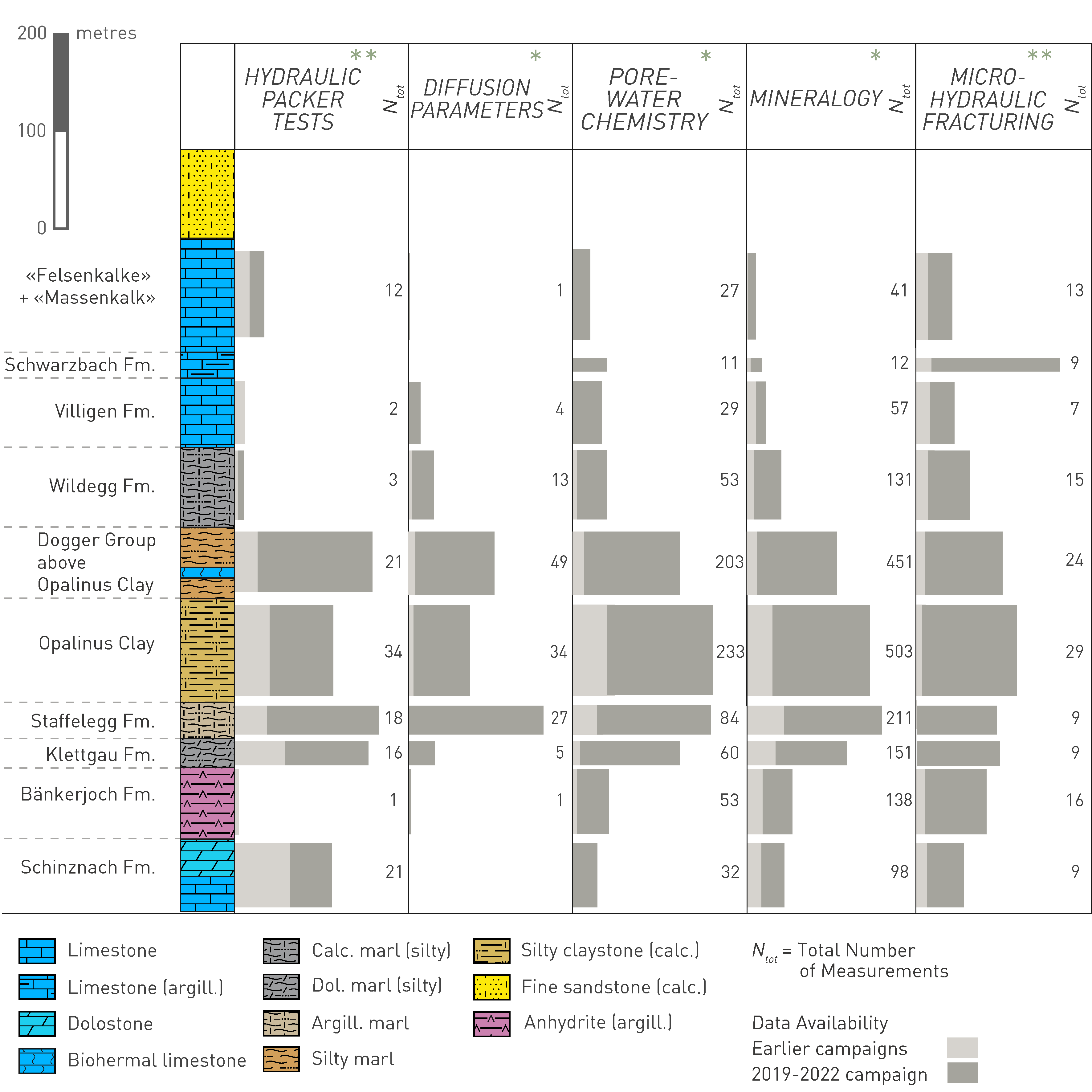
Fig. 2‑3:Increase in size of the database for key parameters during the 2019 – 2022 deep drilling campaign
The above overview includes the 9 new boreholes as well as the BEN, RIN, WEI, SLA1, BEZ and SHA boreholes. Data are projected onto the lithostratigraphic column for the STA2 borehole, which is shown as a reference on the left. For an introduction to the lithostratigraphic column see Section 3.1. Ntot indicates the total number of measurements per formation. The length of the horizontal bars represents the number of measurements normalised by the thickness of the formation. Longer bars thus indicate higher densities of data points in the corresponding formation. Parameters with one asterisk indicate laboratory experiments on drill cores, while parameters with two asterisks represent in-situ measurements in the boreholes.
The figure shows the substantial increase in the database resulting from the new drilling campaign and reflects the investigation focus on the host rock and the surrounding confining units.
A dedicated field investigation programme was undertaken to reconstruct the erosion history of the siting regions over the past 1 – 2 million years as a basis for establishing future erosion scenarios (Section 6.4). In addition to characterising the depth, shape and age of glacially overdeepened troughs, the investigations sought to constrain the age of the Early to Middle Pleistocene gravel deposits for reconstructing past fluvial incision history.
The investigations involved the acquisition of high-resolution 2D reflection seismic data (Nagra 2018), data for seismic surface wave investigations (Nagra 2021) and 11 Quaternary boreholes with ~ 50 to 300 m length (Fig. 2‑2, Tab. 2‑2). The boreholes were fully cored and numerous laboratory investigations were carried out, including sediment age determinations (e.g. Mueller et al. 2024, Tomonaga et al. 2024). Surface outcrops were also studied and sampled to determine relative and absolute ages of the deposits (e.g. Grischott et al. 2020, Scheidt et al. 2023, Thew et al. 2024). Understanding of the past landscape evolution has significantly improved as a result of these investigations (e.g. Gegg et al. 2023, Buechi et al. 2024; see Sections 3.5 and 6.4.1).
Tab. 2‑2:List of Nagra’s 11 Quaternary boreholes drilled 2018 – 2020 including references to data reports
MD: Measured depth below ground level. Borehole locations are shown in Fig. 2‑2.
|
Siting region |
Borehole name |
Abbrevi-ation |
Data reports |
Nagra NAB No. |
Depth Base Quaternary [m MD] |
Final depth [m MD] |
|---|---|---|---|---|---|---|
|
JO |
Riniken-1 Riniken-2 |
|
NAB 18-40 |
41.2 |
52.7 41.2 |
|
|
JO |
Untersiggenthal |
QUST |
NAB 19-01 |
76.0 |
86.4 |
|
|
JO |
Gebenstorf-Brüel |
QGBR |
NAB 19-02 |
111.5 |
123.5 |
|
|
JO |
Gebenstorf-Vogelsang |
QGVO |
NAB 19-03 |
65.0 |
77.0 |
|
|
NL |
Hochfelden-Strassberg |
QHST |
NAB 20-02 |
267.2 |
278.0 |
|
|
ZNO |
Marthalen-Oobist |
QMOB |
NAB 19-04 |
24.5 |
48.0 |
|
|
ZNO |
Neuhausen |
QNEU |
NAB 19-05 |
127.1 |
137.2 |
|
|
ZNO |
Trüllikon-Rudolfingen |
QTRU |
NAB 20-01 |
88.0 |
99.0 |
|
|
ZNO |
Kleinandelfingen-Laubhau |
QKLA |
NAB 20-03 |
253.6 |
263.4 |
|
|
ZNO |
Andelfingen-Niederfeld |
QANI |
NAB 20-04 |
313.7 |
324.0 |
|
|
ZNO |
Adlikon-Dätwil |
QADA |
NAB 22-14 |
303.0 |
313.2 |
The seismic monitoring network in Northern Switzerland has been considerably densified over the last 15 years (Plenkers 2014). The Nagra network operated by the Swiss Seismological Service (SED) currently includes 24 measurement stations, including three in shallow boreholes and one deep borehole station (Diehl et al. 2023, Spillmann et al. 2022). Using this system, all (micro)-seismic events with magnitude Mw > 1 can be detected and located reliably. Nagra also runs a permanent network of 11 Global Navigation Satellite System (GNSS) stations in and around the siting regions (Studer & Zanini 2013). The horizontal and vertical position of these stations is determined with high accuracy and temporal resolution, providing robust information on recent uplift and deformation. The seismic and geodetic monitoring systems substantially improved the understanding of the seismotectonic situation, providing input for the assessment of future tectonic movements (Section 6.2) and erosion (Section 6.4). In the three boreholes MAR1, STA3 and BOZ1, Nagra installed hydrogeological monitoring systems, adding to the pre-existing monitoring system in the BEN borehole (Longridge et al. 2024). This instrumentation aims to derive robust hydraulic heads in the Opalinus Clay, which cannot be deduced from hydraulic packer testing because of short-term drilling-induced effects and the short duration of the packer tests (see Section 5.6.5).
The Mont Terri project is an international research project with currently 22 partner organisations from 10 different countries (https://www.mont-terri.ch). The rock laboratory is located approximately 75 km to the west of the JO siting region in an anticline of the Jura Fold-and-Thrust Belt. It includes a network of underground galleries and niches in the Opalinus Clay designed for various underground experiments. More than 25 years of intensive scientific investigations have significantly increased the understanding of safety- and construction-relevant properties and processes in this rock (see Bossart et al. 2017 and references therein for an overview). The laboratory plays an important role in the development and testing of methodologies (e.g. geomechanical testing, porewater investigations; Minardi et al. 2021, Wersin et al. 2020). It also allows for in-situ testing at larger scales and over longer durations compared to deep borehole experiments (see Section 5.8.3). This report frequently refers to knowledge gained at the Mont Terri rock laboratory, taking into account the differences in the geological history and depth of the laboratory compared to the Opalinus Clay in Northern Switzerland.
Clay-rich rocks are being investigated as host rocks for radioactive waste disposal in various countries (e.g. Belgium, Canada, France, Germany, Hungary, UK). The rock types range from soft, plastic and poorly indurated clays or claystones to brittle, hard mudstones and shales, i.e. very weak to very strong rocks according to the ISRM (1981) classification. The most recent compilation of characteristics of such argillaceous rocks was published by the Clay Club of the OECD Nuclear Energy Agency (OECD/NEA 2022). Comparisons of the properties of the different clay-rich rocks are discussed e.g. by Mazurek et al. (2003; features, events and processes), Mazurek et al. (2009; natural tracer profiles) and Bock et al. (2010; self-sealing properties). Figures comparing the mineralogy, porosity, hydraulic conductivity and diffusion coefficients of the Opalinus Clay with other clay-rich rocks are included in Chapter 5.
The clay-rich rocks with the closest similarities to the Opalinus Clay are two formations under investigation in France:
-
The Callovo-Oxfordian clay host rocks for the planned Cigéo (acronym for Centre Industriel de stockage géologique), a repository for high- and intermediate-level radioactive waste in the eastern Paris basin. Detailed multidisciplinary site investigations of the Callovo-Oxfordian rocks have been conducted nearby in the Meuse/Haute Marne Underground Rock Laboratory (Delay et al. 2007, Leverd 2023).
-
Toarcian – Domerian clay-rich rocks are investigated by a multi-disciplinary research programme in an abandoned railway tunnel in the Causses Basin (see Annex III of OECD/NEA 2022).
Clay-rich rocks much weaker than the Opalinus Clay are investigated in the HADES underground research facility in the Oligocene Boom Clay in Mol (Belgium). The research programme was launched already in the 1970s and included a detailed host rock characterisation programme (see e.g. De Craen et al. 2023 as an example for geochemical aspects). Besides the Boom Clay, the Eocene Ypresian Clay (also a very weak clay formation) is considered as an alternative host rock in the Belgian programme.
Clay-rich rocks much stronger than the Opalinus Clay also play an important role as a radionuclide transport barrier. In the Canadian programme, the potential sedimentary host rock9 for the spent fuel repository is a 30 m thick very low-permeability argillaceous limestone (the Ordovician Cobourg Formation). This formation is sandwiched between more than 200 m of strong clay-rich rocks (shales) above and more than 150 m of argillaceous limestones below (NWMO 2011, 2023), all in all an excellent geological barrier system.
The host rock for the German repository project Konrad for low- and intermediate-level radioactive waste is an Oxfordian oolithic limestone succession. The geological barrier is formed by overlying Lower Cretaceous claystones and marls. Below the host rock low-permeability clay-rich rocks of the Lower Dogger and Lias Groups form a geological barrier (e.g. Rübel et al. 2019). Moreover, a variety of clay-rich formations is currently investigated as potential host rocks for the German repository for high-level radioactive waste (BGE 2020). Among them is also the Opalinus Clay in Southern Germany.
The Permian Boda Claystone Formation – an albitic clay-rich formation deposited in a saline playa lake – is being investigated in Hungary with respect to host-rock properties (see Annex III of OECD/NEA 2022, with detailed references and illustrations). The formation is highly overconsolidated due to a maximum burial of 3.5 to 4.5 km. The hydraulic characteristics of the Boda Claystone Formation partly resemble those of crystalline rocks (large difference in hydraulic conductivities between intact rock matrix and fractured rock).
In the UK programme, two mudstone successions are at early stages of investigation to assess their potential to host higher activity radioactive waste. In the inshore adjacent to the East Coast of England, the focus is on the Ancholme Group, a Middle to Upper Jurassic aged, mudstone-dominated succession. In this area, the Ancholme Group comprises a ca. 180 to 450 m thick succession dominated by clay-rich units, gently inclined towards the offshore within which areas largely unaffected by significant faults are anticipated. In the inshore adjacent to the northwest of England, a mixed succession dominated by Triassic mudrocks and evaporites of the Mercia Mudstone Group is under investigation. Here the group comprises a ca. 200 to 1'600 m thick succession preserved in an extensional sub-basin, part of the East Irish Sea Basin, at depths between ca. 50 m and > 1'600 m.
Clay-rich rocks have a known ability to act as a barrier to fluid flow in the subsurface and have therefore been investigated extensively by the hydrocarbon industry and, in recent years, for carbon capture and storage, as a common caprock and seal hindering upward migration of fluid. Data and understanding from such studies (e.g. Fisher et al. 2023) provide independent evidence for the effectiveness of the clay-rich rocks as a transport barrier (Section 5.7).
In the Canadian programme also crystalline host rocks are investigated. ↩