
This chapter provides an overview of the geological knowledge base of Northern Switzerland (Fig. 2‑1) with a special focus on the detailed site investigations carried out in the third and final stage of the site selection process (SGT Stage 3).
The geology of Northern Switzerland was intensively investigated prior to the start of the Sectoral Plan for Deep Geological Repositories (SGT) process in 2008, providing a well-established understanding of the subsurface and its geological evolution. The stratigraphic, tectonic and hydrogeological framework has been analysed since the middle of the 19th century through applied projects and academic research (e.g. Mösch 1867, Mühlberg 1901, Frei 1912, Amsler 1915, Buxtorf 1916, Heim & Hartmann 1919, Hartmann 1925, Schmassmann 1945, Laubscher 1961, Büchi et al. 1965, Hantke 1967). The intensive exploration campaigns carried out by Nagra in the 1980s (summarised in Thury et al. 1994) and in the 1990s (summarised in Nagra 2002), together with related scientific work (e.g. Matter & Peters 1987, Mazurek et al. 2006, Gimmi et al. 2007), significantly enhanced subsurface understanding of Northern Switzerland. Geophysical field work, together with participation in third-party drilling projects undertaken in the first two stages of the siting process (SGT Stage 1 and 2), further extended the knowledge base, and the integration of this new information improved process understanding (summarised in Nagra 2008b, 2014b). Swisstopo’s 1:25'000 scale geological maps and corresponding detailed explanatory notes (accessible via map.geo.admin.ch), and regional 3D models of key geological horizons and faults developed within the framework of the GeoMol project (Allenbach et al. 2017), supplement this understanding.
The site investigations conducted for the third stage of the siting process (SGT Stage 3) took place between 2015 and 2022. The aim was the characterisation of the key attributes for site selection and the demonstration of the long-term safety for the proposed site (see Section 1.4.3), as well as the demonstration of engineering feasibility. The initial planning of the investigations was summarised in site-specific exploration concepts (Nagra 2014a, 2016). The exploration plan was refined and adapted during the investigations, incorporating learnings as new data were acquired and experience gained. It was also ensured that the regulatory requirements for the geological site investigations (ENSI 2018) were met.
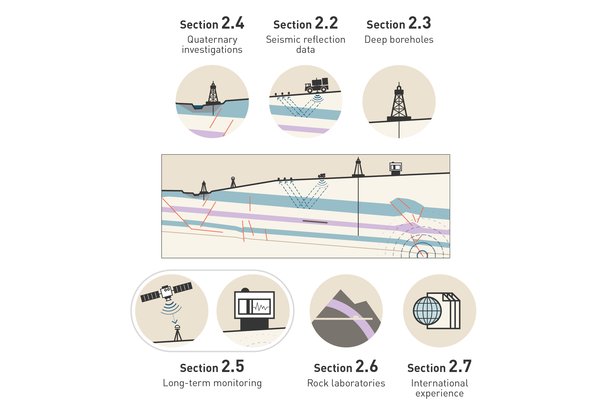
Fig. 2‑1:Schematic overview of important sources of information for the characterisation of the geological barrier
Note that the project also benefited from selected geological outcrop studies (not shown in the figure).
An overview of the most important data sources used to characterise the geological barrier and to evaluate its past and future evolution is provided below and illustrated in Fig. 2‑1. They include data arising from Nagra and third-party field investigations (seismic surveys, boreholes) as well as from decades of research in the Mont Terri rock laboratory. Seismic investigations (Section 2.2) provide 2D or 3D information on the geometry of the geological units and tectonic faults. This information is fundamental for siting a deep geological repository in a subhorizontal to slightly inclined host rock configuration with low deformation. Deep boreholes allow characterisation of the rocks and their properties and the calibration of seismic data (Section 2.3). A shallow investigation programme (shallow geophysics, shallow boreholes, outcrop analyses; Section 2.4) quantifying the processes and rates of the Quaternary geodynamic and erosional evolution provides the understanding necessary to assess the evolution of the geological barrier during the next one million years. Further input regarding future geological evolution is provided by long-term monitoring systems delivering, for example, information on recent seismicity and movements of the Earth’s surface (Section 2.5). Experiments in the Mont Terri rock laboratory hosted in the Opalinus Clay give further insights into key processes in the host rock (Section 2.6). Lastly, the project benefits from the general understanding of the behaviour of clay-rich rocks built up by applied and academic research (Section 2.7).
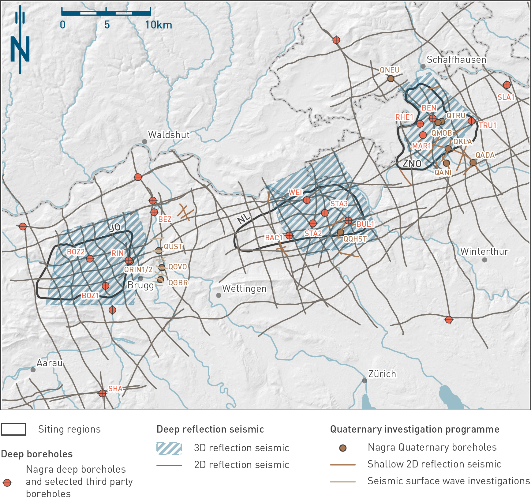
Fig. 2‑2:Important geophysical datasets and boreholes in Northern Switzerland
Boreholes discussed in this report are labelled. See Tab. 2‑1 (deep boreholes) and Tab. 2‑2 (Quaternary boreholes) for further information and references to data reports.