
The main phase of thin-skinned deformation within the Jura Fold-and-Thrust Belt is thought to extend from the Middle Miocene until the Early Pliocene (Fig. 3‑6d; e.g. Becker 2000, Schlunegger & Mosar 2011, Mosar 1999). Undeformed infilled karst features in folded Malm limestones of the Vue-des-Alpes Anticline (located in the Central Jura Fold-and-Thrust Belt, i.e. west of the study area) were dated from 4.2 to around 3 Ma and thus locally represent the end of the main deformation phase in the Internal Jura (Bolliger et al. 1993, Steininger et al. 1996). Nonetheless, several studies examining the front of the Jura Fold-and-Thrust Belt have identified evidence of moderate post-Pliocene tectonic thick-skinned (i.e. involving the substratum beneath the décollement horizon) activity (e.g. Giamboni et al. 2004, Madritsch et al. 2010). Geodynamic considerations support that the more recent deformation also affects the units below the décollement rather than being exclusively thin-skinned deformation (e.g. Mosar 1999; Fig. 3‑6e). In fact, interpretations of seismic reflection data from west of Basel indicate a component of thick-skinned deformation starting from the Late Pliocene onwards (Ustaszewski & Schmid 2007, Madritsch et al. 2008). This inferred basement involvement is also observed in the latest 3D seismic reflection data obtained by Nagra (Section 4.3; Nagra 2024b).
From the latest Miocene into the Pliocene (ca. 7.3 – 4.2 Ma), the North Alpine Foreland drained towards the northeast to the Black Sea via the Aare-Danube River system (Fig. 3‑11; Heuberger et al. 2014, Yanites et al. 2013, Ziegler & Fraefel 2009). This river system is documented by gravel relicts up to 270 m above the recent valley floor of the upper Danube River mostly between Blumberg and Ulm (Aare – Donau Höhenschotter; Villinger 2003). Later in the Pliocene (ca. 4.2 – 2.9 Ma), the Aare – Doubs System draining towards the Rhone and the Mediterranean Sea was established when the Aare-Danube River was captured by the proto-Doubs River in the region of Waldshut. This river reorganisation is potentially related to the sea-level drop in the Medi-terranean Sea during the Messinian salinity crisis resulting from isolation from the Atlantic Ocean (ca. 5.5 Ma; Krijgsman et al. 1999) and a successive backward incision of the palaeo-Rhone and Doubs systems. Alternatively, the headward erosion along the proto-Doubs River could have been caused by strong subsidence in the Bresse Graben (Schlunegger & Mosar 2011). Part of the eroded material was deposited west of Basel and is partially preserved in the form of the Sundgau Gravel (Liniger 1967) and its equivalents in the Forêt de Chaux (northeastern Bresse Graben; Petit et al. 1996).
Towards the end of the Pliocene at the transition to the Quaternary, the Aare – Rhine System, draining towards the North Sea, was established when the Aare-Doubs River was captured by the proto-Rhine River in the region north of Basel. This gave rise to the first deposition of Alpine sediments in the Upper and Lower Rhine Graben (ca. 2.8 – 2.6 Ma; Hagedorn & Boenigk 2008, Westerhoff et al. 2008). The timing and course of these river systems in the Pliocene are subject to larger uncertainty because of sparse sedimentological records and scarce chronological information.
The flow distance from the study area along the Danube towards the Black Sea is considerably larger compared to the flow distance of the Rhine River towards the North Sea. The modern Danube catchment is located more than 200 m higher compared to the Rhine catchment. This difference may have been even more pronounced in the past when the water divide was located farther to the west. For this reason, the change from the Danube to the Rhine system led to a signi-ficant baselevel fall and triggered a subsequent incision wave across the study area and the Central Swiss Molasse Basin (Schlunegger & Mosar 2011, Heuberger et al. 2014, Yanites et al. 2013).
The groundwater flow systems in the bedrock aquifers are influenced by the evolution of topography and of the river network. The Pliocene incision of the Rhine and Aare Rivers affected the regional discharge zones for the deep groundwaters of the Swiss Molasse Basin and of the sedi-mentary cover of the Black Forest (e.g. Waber & Traber 2022).
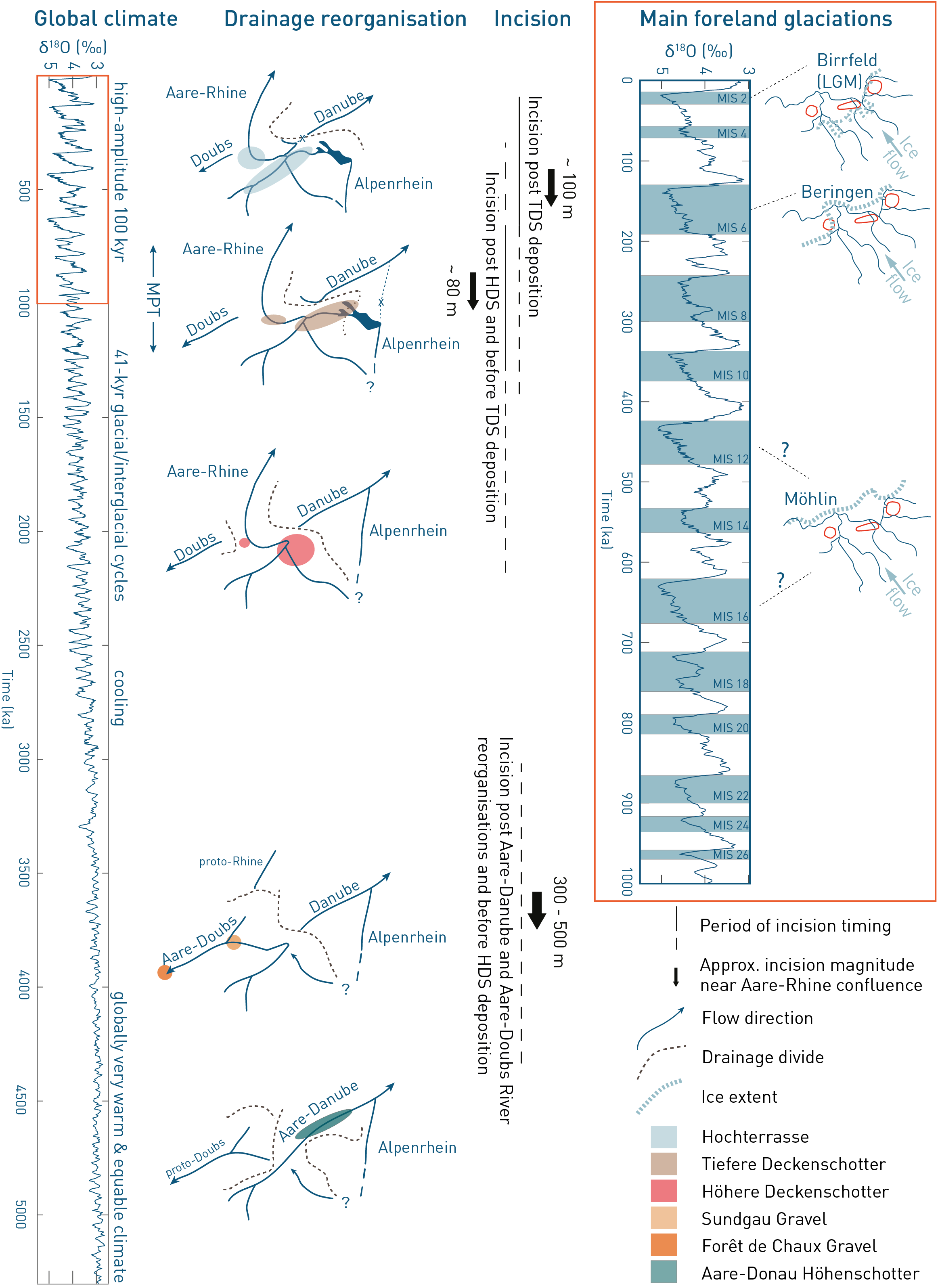
Fig. 3‑11:Main landscape-forming events in Northern Switzerland during the past 5 Myr
Compilation shows global and regional events linked to the Pliocene-Quaternary landscape evolution in Northern Switzerland. δ18O record with marine isotope stages (MIS) based on Lisiecki & Raymo (2005). Incision magnitudes of major drainage reorganisations are based on visual inspection of the Aare – Rhine confluence area based on Heuberger et al. (2014) and yield ~ 300 – 500 m for the Aare-Doubs incision, ~ 80 m between HDS (Höhere Deckenschotter) and TDS (Tiefere Deckenschotter) deposition and ~ 100 m after TDS deposition. Maps with ice extents show present-day river network for orientation.