
The starting point for the conceptualisation of the CRZ is the geological knowledge as described in Section 5.2.1, which is abstracted as illustrated below in Fig. 7‑2 and Tab. 7‑2. The CRZ, in the reference conceptualisation, is taken to extend between the upper deep aquifer above the repository (the Malm aquifer) and down below the repository to the Keuper aquifer. The geosphere modelling domain in the analysis of radiological consequences is also bounded, at the top, by the Malm aquifer, but extends below the Keuper aquifer to the deeper Muschelkalk aquifer.
Within the confining geological units of the Opalinus Clay, there are a number of thin competent (i.e., hard and brittle) horizonal rock units, including the hard beds, embedded between layers of more plastic clay. In the reference safety scenario, in line with current understanding of the site, these rock units are taken to be sparsely fractured and not to form horizontally connected pathways for radionuclide transport (the presence of a hydraulically active confining unit is considered as an alternative safety scenario; see Section 7.3.1).
Local conductive layers within the Keuper aquifer below the repository have been identified towards the area where the L/ILW repository section is planned; however, such features have not been observed in the area where the HLW repository section is planned. Furthermore, groundwater within the Keuper aquifer is characterised by very long residence times and it could be possible that the aquifer is hydrogeologically inactive (Section 4.5.5.4 in NTB 24-17, Nagra 2024i), at least below the HLW repository section. Thus, two conceptualisations are considered (see Fig. 7‑3):
-
Reference conceptualisation: it is conservatively assumed that the Keuper aquifer is hydraulically active and forms a significant advective transport path below the repository.
-
Variant: the Keuper aquifer below the HLW repository section is inactive and radionuclides are only transported vertically across it by diffusion; the CRZ extends vertically downwards to the Muschelkalk aquifer.
Radionuclides reaching the hydraulically active Keuper aquifer can either be transported vertically across it, predominantly by diffusion, or be diverted into the aquifer and conveyed by groundwater flow to a regional aquifer (considered part of the biosphere), where they become substantially diluted. Radionuclides that reach the other deep aquifers, at the boundaries of the geosphere model, are also conveyed to, and diluted in, the biosphere. Any 14C reaching the deep aquifers in the form of gaseous methane is assumed to dissolve. The significant transport time for dissolved radionuclides within these aquifers as well as between these beds and the biosphere is conservatively neglected. i.e., radionuclides that are diverted into deep aquifers are assumed to be directly and instantaneously transferred to the regional aquifer in the biosphere.
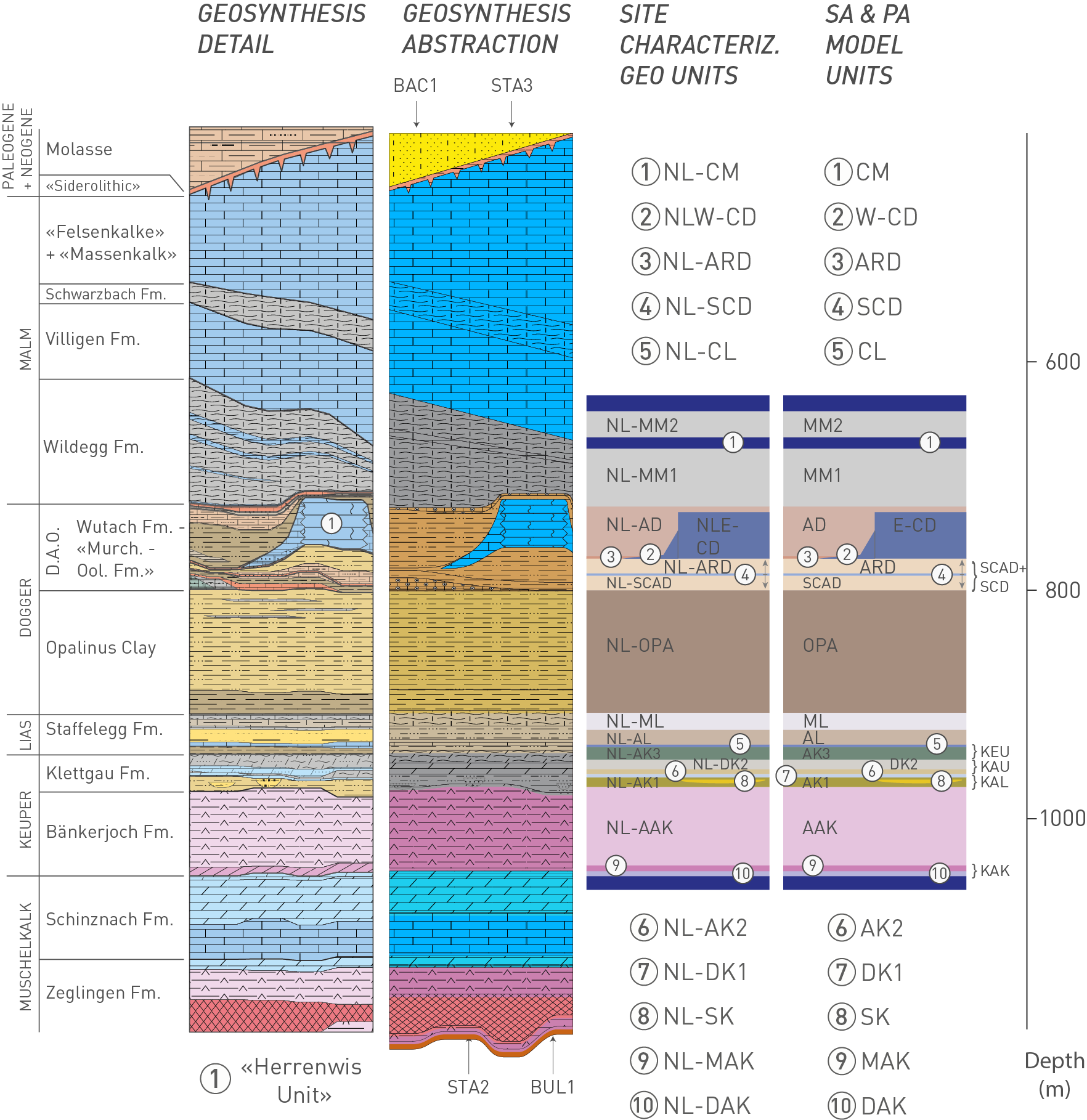
Fig. 7‑2:Abstraction of the sedimentary Mesozoic sequence at the site into units of comparable transport parameters
The abstraction results in the generation of the local “layer-cake” model units for performance assessment and for the analysis of radiological consequences (“SA & PA model units”). D.A.O.: Dogger Group above Opalinus Clay.
Tab. 7‑2:Stratigraphic units, geological abstracted units and abstracted model units for performance assessment and for the analysis of radiological consequences
|
Stratigraphic unit |
Abstracted unit and full name |
Abstracted model unit |
|
|
Wildegg Fm. |
MM2 |
Marly Malm |
MM2 |
|
CM |
Calcareous Malm |
CM |
|
|
MM1 |
Marly Malm |
MM1 |
|
|
Dogger Group above Opalinus Clay |
AD |
Argillaceous Dogger |
AD |
|
E-CD / W-CD |
Calcareous Dogger («Herrenwis Unit») |
E-CD / W-CD |
|
|
SCD |
Sandy-Calcareous Dogger |
SCAD+SCD |
|
|
SCAD |
Sandy-Calcareous-Argillaceous Dogger |
||
|
Opalinus Clay |
OPA |
Opalinus Clay |
OPA |
|
Staffelegg Fm. |
ML |
Marly Lias |
ML |
|
AL |
Argillaceous Lias |
AL |
|
|
CL |
Calcareous Lias |
KEU |
|
|
Klettgau Fm. |
AK3 |
Argillaceous Keuper |
|
|
DK2 |
Dolomitic Keuper |
KAU |
|
|
AK2 |
Argillaceous Keuper |
||
|
DK1 |
Dolomitic Keuper |
KAL |
|
|
AK1/SK |
Argillaceous Keuper / Sandy Keuper |
||
|
Bänkerjoch Fm. |
AAK |
Anhydritic-Argillaceous Keuper |
AAK |
|
MAK |
Massive Anhydritic Keuper |
KAK |
|
|
DAK |
Dolomitic-Anhydritic Keuper |
||