
In the following, we summarise the expected long-term geological evolution21 of the NL siting region over the next one million years. This geological storyboard supports the discussion on the repository evolution in Nagra (2024p).
Long-term rock uplift, fluvial incision and remaining overburden thickness
The Rhine will grow at the expense of the Danube, by headward erosion rather than through major river capture events. The evolution of the river profile will be largely controlled by rock uplift and sediment input. The bedrock erodibility will only be of secondary importance for vertical fluvial incision but might have an influence on lateral erosion.
The spatial pattern of rock uplift in Northern Switzerland over the next million years will continue to be dominated by Alpine uplift, regardless of whether it is a matter of tectonic uplift or isostatic compensatory movements. In simplified terms, the main uplift gradient can be assumed to cause increasingly higher rates from the external foreland basin towards the Alps along a direction that is approximately perpendicular to the Alpine chain. The long-term rates are low. Total uplift of ~ 170 m (between ~ 25 m and a maximum of ~ 360 m [5 – 95%]) over a million years is assumed for the NL siting region. Short phases of significantly higher rates might be associated with glaciations of extensive foreland glaciations (Fig. 6‑48). This in turn may cause temporarily enhanced fluvial incision (after backfilling of perialpine lakes).
Over long time periods, incision rates are generally expected to be in the same range as uplift rates. Significantly greater incision can only be achieved by additionally lowering the regional baselevel. As long as the Rhenish Massif continues to be uplifted, this location (approx. near Bingen; see Fig. 6‑5) decouples the Upper Rhine (and thus the Hochrhein) from the sea. The sedimentary basin of the Upper Rhine south of Bingen is controlled by tectonic subsidence and sediment input at the transition to the Hochrhein near the city of Basel. Today, there is no disturbance of the river profile at this point; the subsidence is roughly compensated for by sediment accumulation. This sedimentation might be additionally linked to a buffer effect associated with the low-subsidence area of the Karlsruhe Swell. Potential elevation gain by short-term oversupply of sediment is compensated for over the long term by vertical incision into these sediments. Averaged over the next million years, however, it is considered possible that the baselevel at Basel might fluctuate by up to ± 70 m.
Under these boundary conditions, a vertical fluvial incision of ~ 160 m is most likely (between 80 and 380 m [5 – 95%]) at the confluence of the Aare and Rhine, i.e. near NL (see Fig. 6‑48). This is in good agreement with Quaternary incision on a million-year timescale around the area of NL. Given these incision estimates, a remaining overburden thickness of ~ 550 m (350 – 670 m [5 – 95%]) can be expected, potentially increased by future evolution of local topography.
Given these constraints, it is therefore expected that the future groundwater discharge area will be located progressively closer to the position of the provisional disposal area. The flow path will be shortened compared to today and incipient decompaction affecting the Malm aquifer due to erosional unloading may then increase hydraulic conductivity. A more active flow system will develop, although this happens only late in the period under consideration. Importantly, the remaining overburden thickness is sufficient to avoid any decompaction effects or to affect the self-sealing capacity of the host rock and the clay-rich confining units. The upper confining units will stay well below the local erosion base, preventing dissolution of carbonate-rich sections. The host rock provides a stable and predictable system in terms of porewater chemistry, sorption, diffusion properties and hydraulic conductivity.
Because of the significant remaining overburden, the aquifers below the host rock will experience negligible changes in their properties. The Muschelkalk aquifer will not be affected by decompaction effects and will not be exposed to direct recharge of weakly mineralised waters. Therefore, deep Muschelkalk groundwaters will remain saturated with calcite and near or at saturation with respect to dolomite in the future, preventing significant dissolution of the carbonate minerals below the provisional disposal area.
Short-term modulation of fluvial incision by glacial/interglacial cycles
Long-term incision will be modulated by phases of sediment accumulation with no net vertical incision. The sediment dynamics will be largely controlled by glacial/interglacial cycles. During the interglacial warm periods, a relatively high precipitation rate is expected and consequently a relatively high water discharge. At the same time, the sediment flux may be limited by a weak coupling between the glacially conditioned sediment sources and the rivers. During a renewed Alpine glaciation, the reworking of periglacial deposits by the advancing glaciers and an increase in the area subject to subglacial erosion should lead to a peak in sediment flux. During the main glacial phase, sediment flux is assumed to be larger than the interglacial rate because of increased glacial activity, sediment generation in adjacent permafrost terrains and the effect of greater climate variability. At the termination of glacial conditions, a peak is inferred in water discharge because of the warming-induced increase in atmospheric moisture and a pulse of meltwater from the retreating ice. The greater water availability induces faster glacial sliding and hence an increase in glacial erosion. In combination with the paraglacial adjustment of the landscape, this should result in a maximum contribution of sediment to the fluvial system. However, after glacial retreat, the sediment is trapped in perialpine lakes and overdeepened basins for up to several tens of thousands of years, thus reaching into the interglacial period.
The expected glacial scenario and deep glacial erosion
According to different anthropogenic CO2 scenarios, 3 to 5 large glaciations (LGM-size or larger) might reach the Alpine Foreland in the next one million years. The next glacial inception will be significantly delayed, and the next large glaciation will only occur after the next ~ 200'000 years (Fig. 6‑48). During extensive future foreland glaciations, deep glacial erosion may take place in the eastern part of the NL siting region, where present-day relief is low. This area could be repeatedly glaciated if future glaciers are of similar or larger extent as the penultimate glaciation (Beringen). Maximum ice thickness is estimated at 400 m and a duration of the ice coverage of a few thousand years.
Total cumulative erosion depth in such a case is is most likely to reach ~ 70 m below the local erosion base (30 – 360 m [5 – 95%]). Because the baselevel has already been lowered, deep glacial erosion could reach the Malm limestone late in the period under consideration. It is expected that the Malm limestone is on average only half as erodible as the Molasse-type rocks in Northern Switzerland. It is thus highly unlikely that glacial overdeepening will reach the host rock.
During cold climate periods, the hydrogeological conditions will be affected by glaciation.
An increase in hydraulic gradient is possible during large foreland glaciations but will be limited in magnitude and with a comparably short duration. The overall effect on advective flow in the host rock during these glaciations is small to negligible. The additional ice load can result in an increase in hydraulic head in the Opalinus Clay relative to the confining units with changing direction of the hydraulic gradient between glaciation and glacial retreat. The temporary increase in advective flux because of glacial loading is considered insignificant.
Occurrence of deep-reaching permafrost
Each glacial period is expected to be associated with permafrost conditions during the phases of coldest temperatures. This timing does not necessarily correspond to the timing of the glacial maximum but might pre- or postdate this peak (Fig. 6‑48). Depending on the glacial scenario, such behaviour may be expected initially after 200'000 years. During coldest temperatures, deep-reaching permafrost might affect the flow systems in deep aquifers mainly in terms of reducing water fluxes and increasing residence times. Permafrost is expected to reach maximum depths of 100 – 200 m.
Because of a lower limit of remaining overburden above Top Opalinus Clay of ~ 300 m, the expected maximum depth of 200 m permafrost does not challenge the barrier integrity of the host rock by freeze-and-thaw effects.
Earthquakes and faulting
The site is located within a low-seismicity intraplate domain. Faulting is primarily related to shortening in the Alps and in the Internal Jura, as well as transtensional deformation within the Upper Rhine Graben and the Hegau – Bodensee Graben. Current plate dynamic forces define the stress field that is predicted not to vary significantly from the present direction. Rates of strain accumulation are anticipated to be low over the next one million years.
As typical for intraplate areas, the location of faulting is expected to change over time, and areas currently seismically inactive might become the focus of future seismic activity. Earthquakes and fault ruptures are thus possible in the vicinity of the siting regions. Accordingly, changes in local stress conditions might trigger faulting. Such changes might be applied by vertical glacial loading or unloading, large erosion events, or by loading from interaction with neighbouring faults (Fig. 6‑48). Importantly, irrespective of timing and trigger, significant offsets may occur along existing larger faults and not along subseismic faults or as a result of new fault creation. Such regional fault zones bound the siting region and will be considered when positioning the disposal areas. Subseismic faults and potential new faults in the Opalinus Clay are expected to be segmented and short in length and offset. Relevant changes of the barrier effect by future earthquakes and faulting are thus not expected.
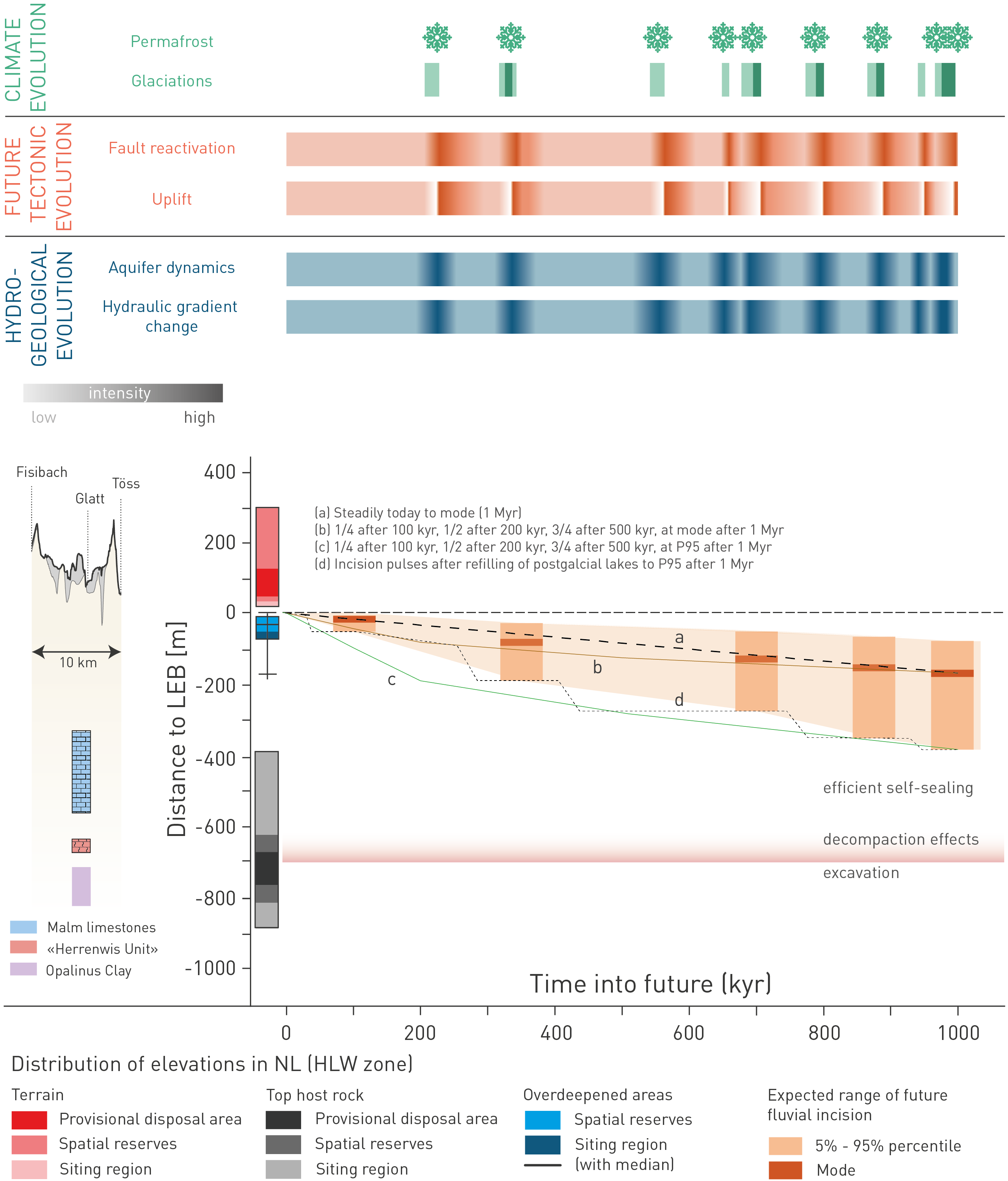
Fig. 6‑48: Schematic diagram summarising the long-term geological evolution of the NL site
The diagram summarises the elements that describe the expected long-term geological evolution over the next one million years for the NL site. The panel on the left-hand side shows the present-day site-specific constraints extracted from the cross-section in Fig. 6‑27 between Fisibach and Töss and a simplified depth profile with boxplots highlighting the distributions of host rock, local topography and glacial overdeepenings within the siting region, the spatial reserves and the location of the provisional disposal area. The local erosion base (LEB) constitutes the reference for the depicted present-day elevations and the future evolution. As a result of long-term rock uplift, modified by transient climate effects, the local erosion base will be lowered by fluvial incision (orange boxes in panel on right-hand side, see mode for the most likely values of fluvial incision). Potential incision pathways are possible during the one million years (e.g. a or b), others are less likely but shown nevertheless because they provide potential calculation cases to show the robustness of the site safety (e.g. c and d). Phases of glacial erosion with potential overdeepening are also highlighted in this upper right panel. Such phases of glacial erosion are coupled to large future foreland glaciations, as depicted by the dark-green bars in the panel "Climate evolution". Note that glacial overdeepening is not shown in the erosion plot below (see Fig. 6‑44 for full remaining overburden, including glacial overdeepening). Glacial conditions and permafrost, however, are expected to occur in semi-regular intervals. The timings delineated here correspond to the 500 PgC scenario of future climate models. The panel "Future tectonic evolution" also highlights a certain synchronicity with future glaciations. For instance, this can be pulses of increased rock uplift after deglaciation (rebound) or phases of enhanced fault activity by reactivation from static stress changes. In general, however, fault reactivation along pre-existing structures might occur at any time within the one million years, and the increased rock uplift is expected to balance out over the long time period. The climate and tectonic triggers may alter the hydrogeological conditions (blue bottom panel). Accordingly, such changes might occur synchronously with the phases at and shortly after glaciations.
For the erosion assessment, the expected evolution presented here, includes the 5 – 95% uncertainty range. ↩