
Managing knowledge and uncertainties in the context of assessing the long-term safety of a deep geological repository is challenging, in particular because of the long time span to be considered. In this section, the main procedure used is highlighted.
The model cascade
Two main questions are addressed to ensure barrier integrity and long-term safety with respect to future erosion: (i) how much remaining overburden thickness is expected in the siting regions after the periods under consideration and (ii) what is the probability of excavation at the end of one million years? Accordingly, the data provided here are used for the safety-based comparison of the siting regions and as input for safety analysis. The remaining overburden in metres and excavation probability in percent are the main outputs of the erosion model (Fig. 6‑29). Both outputs can be calculated for any position within the area of interest. The focus is on the location of the provisional disposal area and its anticipated depth within the host rock Opalinus Clay.
The structure of the erosion model resembles a "Roman Fountain" where the output of Model A (Fluvial incision, i.e. future evolution of the local erosion base) generates input for Model B (Evolution of local topography) and Model C (Deep glacial erosion). The separate consideration of each of the three processes and subsequent combination in the model cascade allow future erosion in the siting regions to be critically assessed and compared.
Model A starts with simulations of the fluvial incision along the Hochrhein. Model B incorporates the 3D geology and simulates the response of local rivers and hillslopes to the derived incision of Model A, extracted at three selected points downstream of each siting region (Section 6.4.3.1). Both stable drainage networks and plausible alternative drainage scenarios (Section 6.4.3.2) are included to account for uncertainties in future channel dynamics, especially in JO. The latter considers the development of new valleys cutting across topographic highs, such as the Bözbergplateau, in conjunction with large future foreland glaciations. Output of Model B provides the remaining overburden thickness and an excavation probability with excluding glacial overdeepening. Incision of Model A and the different drainage scenarios of Model B are input data for Model C. The calculation chain of Model C (Section 6.4.3.3) combines several aspects to be evaluated with respect to future deep glacially eroded troughs. The output of Model C provides estimates of remaining overburden thickness and excavation probabilities including glacial overdeepening.
To consider uncertainties for timescales of 100'000 and one million years, a hybrid approach was developed with as much probabilistic treatment as possible. Where a probabilistic treatment was not feasible, scenarios were specified covering what was considered a critical range of possibilities. The whole process was guided by a sensitivity analysis to identify critical parameters and processes in the model cascade. Models A and B are based on numerical simulation, while Model C processes the uncertainties analytically.
Expert elicitation
In the context of future erosion modelling, like in many other areas of science and engineering, modelling has to be carried out against a background of pronounced uncertainties. Whenever there is not enough observational data to determine these uncertainties quantitatively, it is unavoidable to employ expert knowledge for this purpose (Oppenheimer et al. 2016). Within the solid-earth-geosciences, this is particularly the case for seismic and volcanic hazard and risk assessments, in particular when nuclear facilities are involved. However, more recently, expert elicitation has been used in assessment of climate parameters and models (e.g. Yucca Mountains; Dewispelare et al. 1995, Sebok et al. 2022, Bamber et al. 2019) or even in upcoming topics as carbon capture and sequestration (Moore et al. 2024).
Inclusion of expert knowledge must be carried out in a structured manner, as otherwise the results can easily become unreliable and not reproducible (Budnitz et al. 1997, Oppenheimer et al. 2016). This realisation has led to the development of a number of methodological approaches to structured expert elicitation, of which the protocol of the Senio Seismic Hazard Analysis Committee (or SSHAC; Budnitz et al. 1997) and the Sheffield Elicitation Framework (SHELF; Gosling 2018) are two well-tested examples. The aim of both methods is to describe uncertain quantities of interest (QoI) as probability distributions that represent the expert knowledge of a group, based on expert judgment of their members. It is important to note that there is a certain vocabulary inherent that may be uncommon. To avoid misunderstandings, brief explanations of the most common terms are added below (O’Hagan 2019).
Expert judgement (also expert opinion) describes the individual representation of one (or a group of) expert’s scientific judgement on a specified topic, in this case for instance the uncertainty of a model input parameter. This rational judgement is based on available data and the expert’s scientific know-how and experience and is provided after a training on the influence of cognitive biases (Kahneman et al. 1982) in decision making, especially such as anchoring, availability bias or overconfidence but also the more general aspect of group dynamics.
The probability concept behind expert judgement is that of subjective probability. Subjective probabilities (Cooke 1991) are the expert’s degrees-of-belief formally expressed as probabilities. They are called "subjective" because they follow individual (or group’s) judgements. These probabilities are nevertheless informative and scientific (O’Hagan 2019) and one of the existing legitimate probability concepts that meet Kolmogorov’s axioms (Galavotti 2005).
Elicitation describes the process of gaining the expert’s judgement. The uncertainty elicitations for the parameters relevant for the erosion assessment at Nagra followed the SHELF protocol (Gosling 2018), which is a two-step structured group elicitation framework for carrying out the elicitation of subjective probability distributions for quantities of interest (QoI). The actual elicitations are done in workshops which are led by an experienced facilitator (moderator) who has been trained in all aspects of the SHELF protocol.
The first step requires the individual elicitation of a set of quantiles (e.g. median, tertiles/quantiles, upper and lower bounds) for the uncertainty distribution of interest, one for each expert. In the second step, the expert group derives a single group distribution, which reflects an integrated view of the uncertain quantity. This means that all arguments brought up during the group discussions are considered, as they would be seen through the eyes of a rational impartial observer (RIO) (Gosling 2018, O’Hagan 2019) and it requires that all experts exchange their individual judgments with the role of RIO. The RIO perspective takes into account the combined knowledge of the group but gives some (perhaps more convincing) arguments more weight than others. The facilitator "acts" on behalf of the RIO (and thus in agreement and collaboration with the experts), when aggregating the distributions.
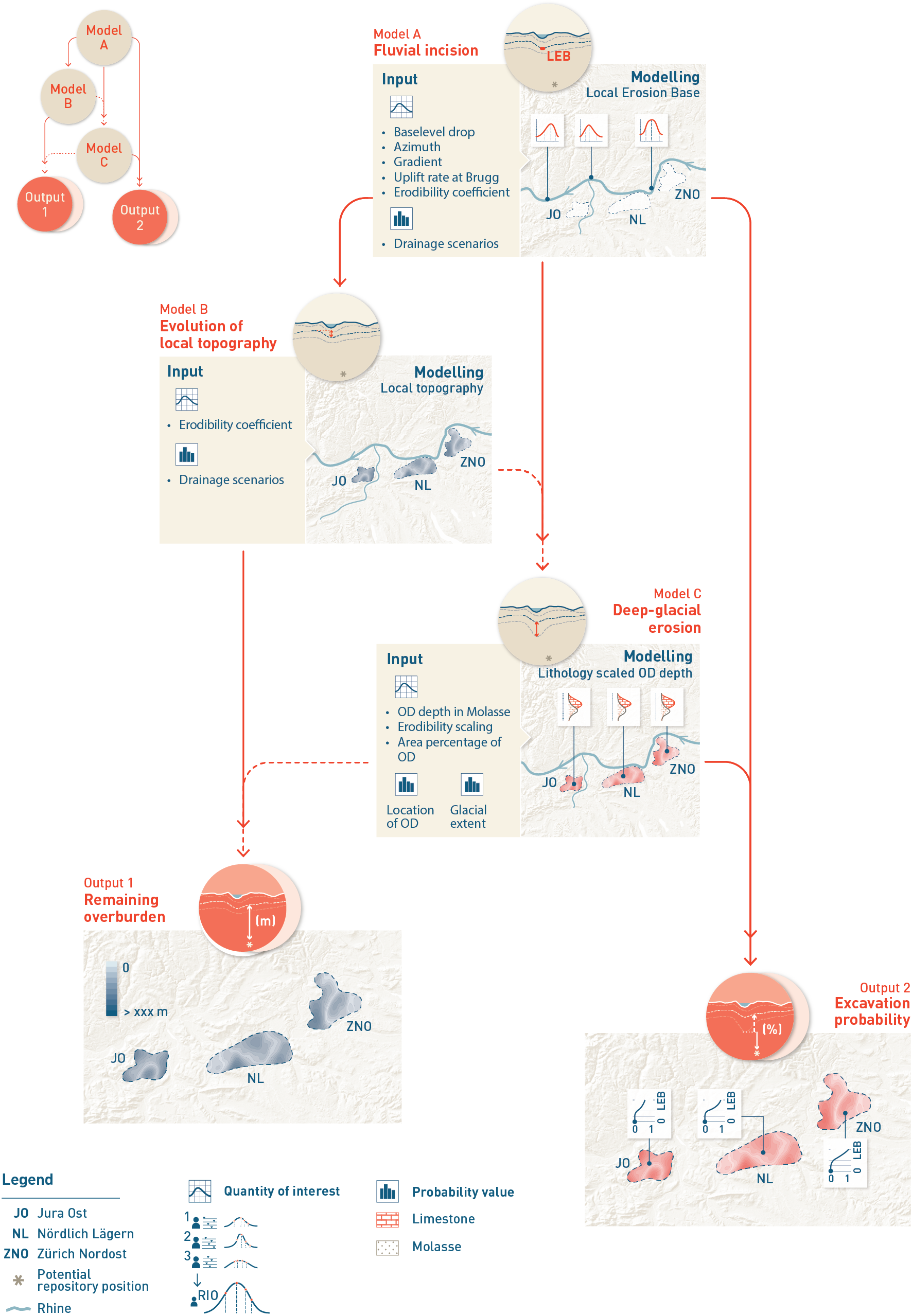
Fig. 6‑29:Simplified flowchart for calculating the remaining overburden thickness and probability of excavation at time Tx
The hybrid probabilistic model consists of three submodels: Model A: simulation of the local erosion base (LEB), Model B: accounting for the effects of local topography, Model C: assessing the probability of glacial overdeepening (OD) and evaluates the combined (glacial and fluvial) probability of incision below a certain vertical position (e.g. the level of the provisional disposal area). Both Model B and Model C depend on the output of Model A. The glacial part of Model C does not depend on the output of Model B. It is based on the LEB and does not account for local topography, i.e. Model C only takes glacial overdeepening events into account that cause an overdeepening below the LEB. However, Model C does depend on scenarios of alternative drainage networks that are developed within/for Model B. Note that final distributions of remaining overburden thickness and excavation probabilities are calculated for selected locations only. Also note that all listed input parameters (left side of subfigures) are quantities of interest for which uncertainties were assessed by elicitation following the SHELF protocol. Finally, it is possible to calculate non-glacial excavation probabilities (parallel to Indicator 1) and combined non-glacial and glacial distributions of remaining overburden thickness (parallel to Indicator 2).
The RIO distributions were fitted with parametric distributions that best reflected the elicited quantile values. Importantly, these RIO distributions comprise the uncertainty that is propagated into the model (Fig. 6‑29). In Fig. 6‑29, all input parameters (left side of each Model) are quantities of interest for which the uncertainties were assessed in SHELF-based elicitation workshops. A total of 34 parameter uncertainties have been evaluated to be used in the modelling or for plausibility checks (see Nagra 2024k for more details). Not all quantities, however, were assessed as probability distributions, some were provided as scenario weights or event probabilities. Because the elicitations were conducted within the erosion team at Nagra with usually 3 – 5 experts per workshop, it was particularly important to include both, the expertise in local geology and geomorphology, as well as expertise in process understanding. The facilitator was supported by an external expert with a strong background on statistics and probabilities, who was trained on all SHELF aspects. The high number of parameter uncertainties required prioritisation regarding, which parameters to treat with most effort (e.g. a higher number of experts, more time etc.). This prioritisation was supported by a sensitivity study. In exceptional cases, a pragmatic deviation from the protocol was allowed (see Nagra 2024k for more detail).
It is important to recapitulate that a rigorous evaluation of prior and present conditions of the landscape and the processes that shaped it was conducted by an extensive scientific programme over several years. The available outcomes of this programme (see also Nagra 2024k for more detail) were provided to all the experts prior to the workshops to ensure that all experts were 'reading from the same page' and that they had access to the same factual basis. In this report, the main evidence is provided in the previous Sections 6.2, 6.3, 6.4.1, as well as Sections 3.4.5 and 3.5.
In the following sections, RIO distributions are provided for the most important parameters used in the respective models only. They are provided with a brief reasoning, which in turn is based on the evidence provided before, partly supported by additional global data or more process-related expertise, which might then be shown or cited individually. More detail on the modelling and parameters can be found in Nagra (2024k).
Presentation of results
In this report, the results are shown only for the one-million-year timescale, with the exception of the intermediate results of future fluvial incision. The final calculations are provided for the provisional disposal areas of each site. To allow a more qualitative comparison within the wider areas containing the spatial reserves, an abridged calculation was used for a set of additional coordinates (Nagra 2024k) in each siting region. To follow the general procedure of the safety-based site comparison, different outputs were generated to evaluate criterion 2.2 (Erosion) and criterion 3.3 (Predictability of long-term changes) of the Sectoral Plan (SFOE 2008). These outputs, as well as considerations beyond one million years, are only reported in Nagra (2024k). Of the full range of uncertainties presented by the total assumed probabilities, the 5 – 95% range is considered the "expected range" in this assessment.