
In Sections 6.4.1.2 to 6.4.1.4, it has been shown that the Quaternary landscape of Northern Switzerland is shaped by the effect of multiple glacial/interglacial cycles with phases of sediment accumulation and vertical incision (including multiphase deep glacial erosion). The distance from the Alpine chain and from the ice margins, as well as the erodibility of the outcropping rocks led to marked differences between the present-day landscapes of the three siting regions. These differences are highlighted along the summary profile through all the siting regions (Fig. 6‑27). The consequences which these differences have with respect to the siting regions (e.g. depth of the Opalinus Clay) and which thus define the different boundary conditions are further described in the following Section 6.4.2.2.
Mainly because of the general SSE-ward dip of the strata in Northern Switzerland different lithologies crop out in the three siting regions, i.e. mainly Mesozoic rocks in JO and Paleogene/ Neogene rocks in NL and ZNO. The bedrock underlying Quaternary unconsolidated sediments in NL and ZNO, i.e. the rocks that are subject to erosion, are comprised of easy-to-erode assemblages of Molasse sediments of Northern Switzerland. Harder-to-erode rocks (e.g. Malm limestone) are located only at depths of several hundreds of metres. JO, in comparison, is characterised by a cuesta landscape with alternating harder- and easier-to-erode rocks (Fig. 6‑21). Harder rock types (see Fig. 6‑27) are presently located close to the surface and probably influenced the present stability of the plateau-like landscape in JO.
No glacial overdeepening is located within the HLW perimeter of JO; the closest occurrences can be found in the lower Aare Valley east of JO. In contrast, in the NL and ZNO siting regions, glacial overdeepenings are significantly deeper than in the lower Aare Valley. This observation can be attributed to two factors. On the one hand, the glacial troughs in NL and ZNO were cut into more erodible sedimentary rocks of the Molasse (Fig. 6‑24), while the hard limestone layers in the lower Aare Valley slowed down erosion (Fig. 6‑25). On the other hand, glaciations during past ice ages have impacted the three siting regions to varying degrees. The map of the ice extent shown in Fig. 6‑18d, Fig. 6‑24 and the simplified bars in Fig. 6‑27 illustrate these differences based on three extensive and relatively well-known glacials in Northern Switzerland (Möhlin, Beringen and Birrfeld). Only the most extensive glaciations reached the JO siting region, and the glaciers were presumably less thick than in NL and ZNO. During the last ice age, the ice cover in ZNO was thicker and more extensive than in NL. Such patterns can be expected during future glaciations.
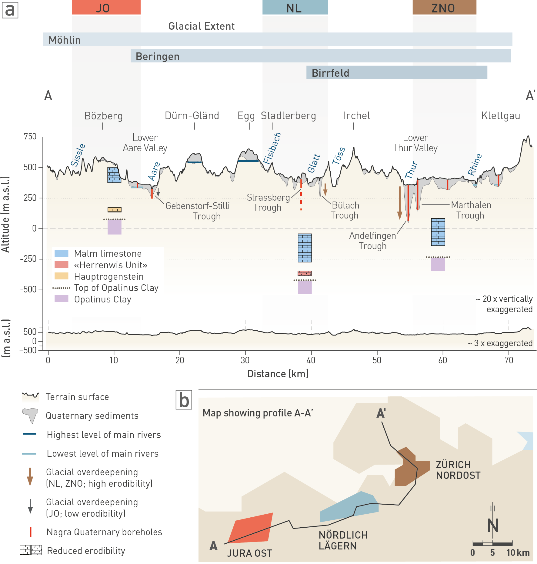
Fig. 6‑27:Cross-section through the siting regions with the morphological and geological conditions that are key to assessing future erosion processes
The synthesis cross-section (a) shows the present-day topography, the main palaeoriver levels (highest fluvial level in dark blue and lowest level in light blue, the latter corresponds to the LEB) and glacial overdeepenings. Quaternary boreholes drilled during Nagra’s investigation programme are shown (Strassberg Trough borehole dashed because it is not located at the cross-section position, see Fig. 6‑26b for comparison), as well as a simplified stratigraphy focusing on the host rock (Opalinus Clay) and erosion-resistant rock types above it (Fig. 6‑21). The blue bars above the figure show comparatively well-known extents of earlier glaciations (Fig. 6‑18d). The extent of the Birrfeld glaciation marks the LGM of the most recent ice age around 21'000 years ago. The Beringen and Möhlin glaciations formed during earlier ice ages that probably occurred between 100'000 and 650'000 years ago (Fig. 6‑12). (b) Simplified map showing the location of the cross-section with respect to the siting regions.