
Glacially overdeepened, often back-filled troughs in Northern Switzerland are distinct features that have been eroded below the local erosion base. Areas with vestiges of deep glacial erosion constitute the third important reference compartment (see Section 6.4.1.1) for the erosion assessment.
Main glacial and subglacial erosion processes
The main processes of direct glacial erosion are abrasion and quarrying, which depend on the temperature and velocity of the basal ice, debris concentrations, bedrock properties, ice thickness and subglacial water pressure (e.g. Iverson 2002, Bennett & Glasser 2009, Burki 2009, Swift et al. 2015). Significant wear to the glacier bed can also be caused by subglacial fluvial action, similar to the bedrock incision by subaerial streams. The efficiency of subglacial drainage not only affects meltwater erosion but also likely plays a predominant role in evacuating sediments produced by erosion and thus keeping bed surfaces accessible for further erosion. Concerning integrated effects over large areas, abrasion and quarrying may be largely responsible for the overall eroded volumes (e.g. Drewry 1986, Burki 2009). However, with respect to maximum possible erosion depths, subglacial fluvial action likely plays an important role (Fischer & Haeberli 2010).
The latter view is supported by climate-driven ice-flow modelling (see Section 6.3.2, Fig. 6‑16). Transient ice-flow modelling of the Rhine Glacier system over the course of the last glacial cycle indicates that the sliding distance is greatest at the base of Alpine valleys where sliding is fastest, and the duration of ice occupation is longest (Fig. 6‑16c). However, the sliding distance does not correlate well with the location of existing overdeepenings in the Alpine Foreland owing to the smaller sliding speeds near the ice margin and the short time period during which ice covered the distal foreland (Fischer et al. 2021). On the other hand, time-integration of the flow accumulation area yields a metric for erosion by subglacial water flow. Results from simulations of the Rhine Glacier system during advance and retreat in the foreland indicate that subglacial water discharge is high and focused along glacial valleys and existing overdeepenings (Fig. 6‑16Fig. 6‑30d).
The formation of glacial overdeepenings is likely the result of the combined action of ice and basal water flow and depends on the extent to which processes and feedbacks are able to focus erosion and maintain the evacuation of water and sediment (Cook & Swift 2012). The deeply incised troughs and overdeepened valleys in the Swiss Plateau therefore presumably formed time-transgressively during periods of ice advance, when the steep surface slope of the ice margin provided the large hydraulic gradients necessary for a vigorous subglacial water flow and an efficient sediment evacuation from the ice-bed interface. They may also have formed during the retreat phase by the outburst of subglacial meltwater dammed behind a cold-based ice margin or a marginal permafrost wedge (Piotrowski 1994, Hooke & Jennings 2006, Stumm 2010, Kehew et al. 2012, van der Vegt et al. 2012).
Deep glacial erosion is expected to slow down within more erosion-resistant rocks (such as limestone). Good examples for such behaviour are observations from the lower Aare Valley (Fig. 6‑25), but also from the Finger Lakes in New York (e.g. Mullins et al. 1996). The Cayuga Lake Basin, for instance, seemingly shows a limiting effect on incision when reaching the Onodaga limestone (Mullins et al. 1996, Bloom 2018, see also Nagra 2024k for more detail). When space is available, subglacial erosion tends to widen the overdeepening within the softer material instead of vertically incising into the harder rocks. In contrast, inneralpine overdeepenings carved in harder-to-erode rocks can reach a significant depth (e.g. Magrani et al. 2020). Here, however, topographic steering inside the preconditioned Alpine valleys may dominate over lithological control. Limited efficiency of erosion in limestone might also be the case, for example, because large amounts of subglacial water may be lost into the underlying limestone karst if available (a process known as underdraining; Grust 2004, Gremaud & Goldscheider 2010, Braakhekke et al. 2017) thereby preventing the build-up of high water pressures that are favourable for active erosion, and the energetic water flow necessary for sediment evacuation.
Sills within the overdeepenings may locally lead to the formation of narrow inner gorges/canyons (e.g. Bandou et al. 2023) but very limited data is available about the abundance of such features in the distal Alpine Foreland.
Glacial overdeepenings in Northern Switzerland
The glaciations in Northern Switzerland caused deep erosion into the bedrock (mainly Molasse, but in the Aare Valley lime- and marlstone were also affected) and the formation of overdeepened troughs (Fig. 6‑24). The glacially eroded Molasse assemblage in Northern Switzerland comprises a variety of different, yet mostly easily erodible, rock types. On the rare occasion where overdeepening in Northern Switzerland reached limestone (Fig. 6‑25), the depth is considerably reduced. Furthermore, visual inspection of the map pattern (Fig. 6‑24, east of Aarau and south of Brugg) suggests that overdeepening tends to widen within the easier erodible Molasse assemblage rather than to extend into the harder limestone units. Although a multitude of reasons could be considered for this effect (e.g. distance to ice margin, topography of Internal Jura as a barrier), lithological control seems reasonable (see Section 6.4.3.3 for more detail).
Some of the troughs in Northern Switzerland, such as the Strassberg Trough (Fig. 6‑26b), show a multiphase filling, whereas the fillings of others seem to be dominated by only one phase (e.g. Gebenstorf – Stilli Trough, Fig. 6‑25, Fig. 6‑26a; Gegg et al. 2021). There is evidence for a multiple reactivation of the same trough by several glaciations (e.g. Bodensee Trough, Strassberg Trough), but in other cases troughs can occur side by side (e.g. Strassberg and Bülach Troughs, Fig. 6‑26b), indicating a temporal and lateral shift of the overdeepening process.
The finding of pre-LGM sediments preserved within many overdeepenings (e.g. Dehnert et al. 2012, Buechi et al. 2018) suggests that not all glaciations were able to excavate the postglacial sediment infill of the previous glaciation and cause renewed overdeepening (Buechi et al. 2018). In ice-marginal areas of the North Alpine Foreland this preservation is often a result of changes in spatial focus and magnitude of subglacial erosion between different glacial periods (Buechi et al. 2024). On the other hand, progressive deepening over successive glacial cycles may also have taken place because ice flow is likely to be diverted from hills and ridges into already existing troughs and valleys (Kessler et al. 2008). This topographic steering is part of a positive feedback mechanism that causes the thicker and faster-flowing ice to generate more basal melting, which in turn will further increase basal sliding and sediment evacuation and consequently result in enhanced erosion. The glacial overdeepenings in the foreland often show a system of branching troughs (e.g. in eastern NL and ZNO, see Fig. 6‑24). Breakthrough channels or ice-marginal drainage (Fig. 6‑22b) can lead to new passages for ice that might subsequently focus (sub)glacial erosion with overdeepening. This process is thought to be more likely with repeated glaciations.
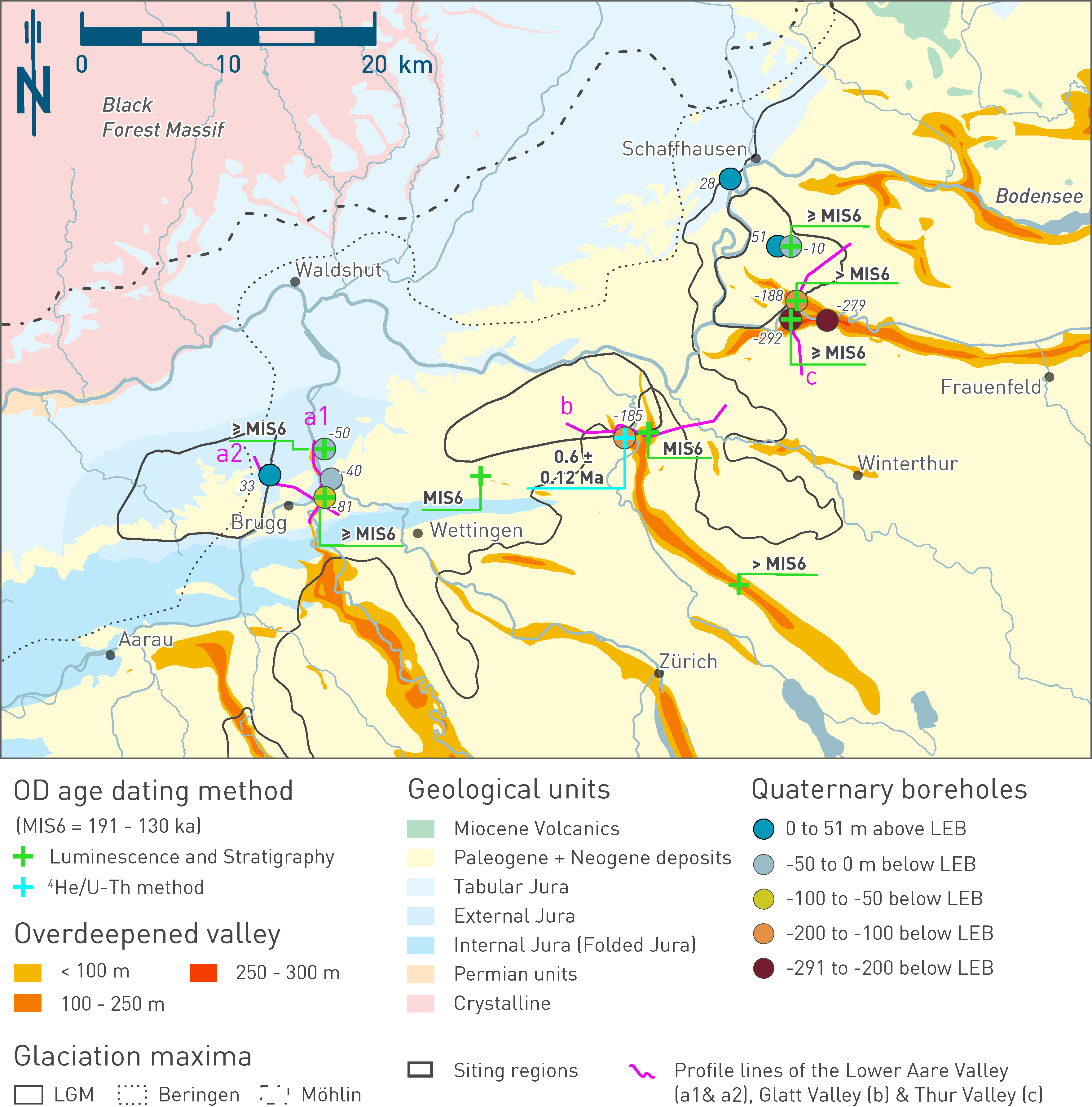
Fig. 6‑24:Overview map showing the glacial overdeepenings and the underlying rock units
Overdeepening depth is depicted by sediment thickness below the local erosion base. The LGM (Bini et al. 2009) and the Beringen and Möhlin ice extents (Preusser et al. 2011) are drawn as solid, dotted and dash dotted black lines, respectively. It is conspicuous that almost exclusively the more easily erodible Molasse sediments were overdeepened (yellow colours). An exception is the lower Aare Valley, east of the JO siting region, where, amongst others, erosion-resistant Malm limestones were glacially overdeepened (Fig. 6‑25). The locations of boreholes drilled during Nagra’s Quaternary investigation programme are colour-coded and labelled with respect to their depth below the local erosion base. Selected ages reveal the timing of filling and thus postdate the deep glacial erosion event (e.g. Tomonaga et al. 2024, Mueller et al. 2024, Gegg et al. 2021). Also shown are the locations of the four interpretative cross-sections (a) through and across the lower Aare Valley, (b) across the Glatt Valley, and (c) across the Thur Valley which are shown in Fig. 6‑25 (a1) and Fig. 6‑26 (a2, b and c).
It is not always clear whether the observed multiphase backfilling cycles represent single advances within one glacial or different glacial stages. In general, the glacial sediments of overdeepened troughs are difficult to date, and available ages have large uncertainties. Evidence for significant overdeepening in Northern Switzerland exists for the Beringen and Möhlin glaciations. The oldest age so far, derived for the older part of the filling of the Strassberg trough, revealed a minimum age of 610 ± 120 ka applying the 4He/U-Th dating method on porewaters (see Nagra 2024k, Tomonaga et al. 2024 ). Few glacial troughs are known to have been eroded into the bedrock during the LGM, although at positions closer to the Alpine chain (e.g. perialpine lakes). In contrast, mostly inlaid terminal glacial overdeepenings were formed in the distal foreland (Buechi et al. 2024). However, the Habsburg glaciation was of similar glacial extent and may be responsible for overdeepening in the study area such as the Birrfeld Trough. Dating efforts accompanying Nagra’s Quaternary drilling programme are summarised and discussed in Nagra (2024k).
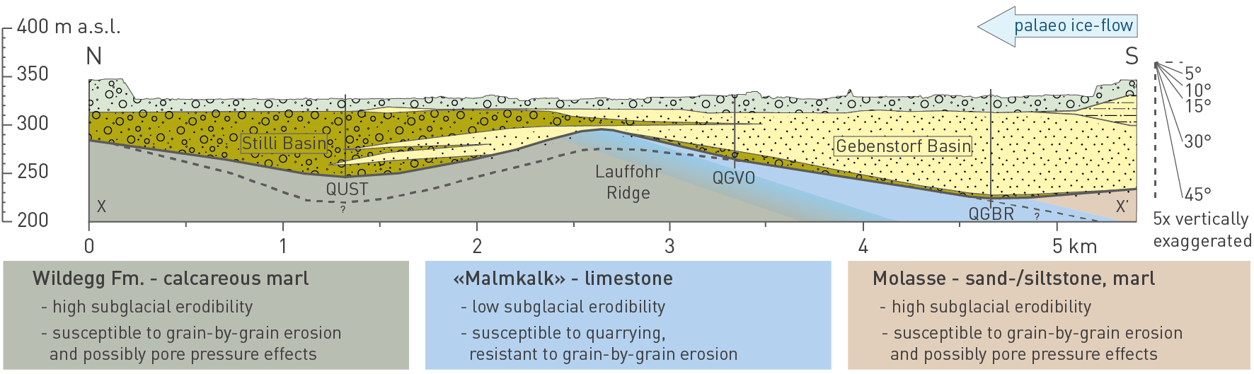
Fig. 6‑25:Longitudinal profile through the Gebenstorf – Stilli Trough close to Brugg
The section (see Fig. 6‑24; a1) is based on seismic cross-sections and boreholes (Gegg et al. 2021) . The orientation of the profile and relative amounts of erosion indicate that the Malm limestone forms a resistant zone in which the overdeepening capacity decreases relative to the Molasse to the south and calcareous marls to the north.
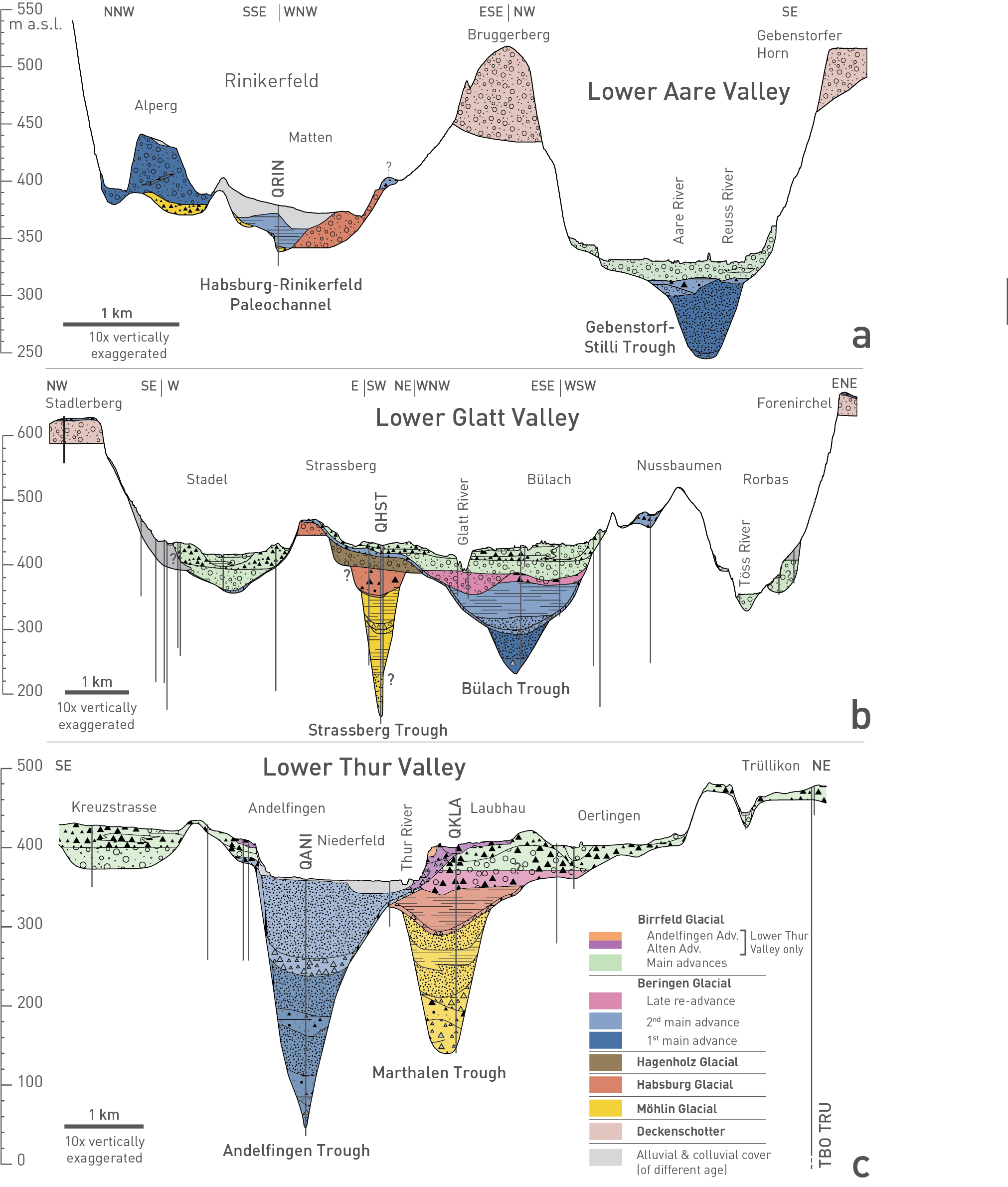
Fig. 6‑26:Cross-sections characterising the Quaternary deposits in the lower Aare Valley, the Glatt Valley and the Thur Valley
The sections represent an integrated interpretation of high resolution 2D seismic data, borehole and outcrop data (Nagra 2018). The 10× vertically exaggerated profiles highlight forms, depths and filling of selected and representative glacial overdeepenings. (a) Lower Aare Valley with the fluvioglacial Habsburg – Rinikerfeld Palaeochannel (QRIN) and overdeepened Gebenstorf – Stilli Trough (after Gegg et al. 2021). (b) Glatt Valley with the overdeepened Strassberg (QHST) and Bülach Troughs. (c) Lower Thur Valley with the overdeepened Andelfingen (QANI) and Marthalen (QKLA) Troughs (Buechi et al. 2024). See Fig. 6‑24 for location.