
Channel-hillslope coupling
Fluvial incision and deep glacial erosion processes determine the pace at which hillslopes respond to baselevel changes. Topographic slope stability depends for instance on the slope angle, controlled by the fluvial baselevel and associated mass movements. Thus, the nature of channel-hillslope coupling will drive denudation of the topography (Fig. 6‑22a). This coupling also provides the link between the landscape compartments that define the local erosion base and local topography (see Section 6.4.1.1).
Rock properties (e.g. rock strength, fracture spacing, orientation of discontinuities with respect to slope), vegetation cover, and climate factors add to the control on hillslope stability or failure and can influence denudation rates. The distinct morphology and different geomorphic process rates that define a landscape need to be incorporated into any future assessment of erosion.
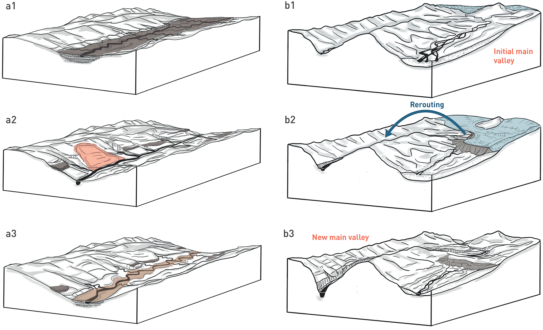
Fig. 6‑22:Conceptual figures of local landscape evolution by (a) local baselevel fall of a main river, and (b) the formation of a breakthrough channel in an ice-marginal setting
Sequence (a) starts with a mature main river valley characterised by a wide aggraded valley floor (a1; dark brown). A pulse of fluvial incision of the main river through the former valley infill and into the bedrock (local baselevel fall) follows in (a2). This stage includes the formation of terrace relicts above the former valley floor (dark brown), propagation of the incision signal along tributary streams and hillslope response (e.g. landslides; red). More advanced adjustment to the new local baselevel is indicated in (a3), with the formation of a new main valley floor (light brown) and a general widening of the valley shape by continuing local erosion. Sequence (b) starts with a pro-glacial main valley (b1; glacier shown in light blue). Glacial advance in (b2) causes blocking of the former main valley by a terminal moraine (greyish brown), and subsequent rerouting of the ice-marginal main drainage into an adjacent valley. The new drainage erodes the former ridge at the location of overspill, thereby creating a breakthrough channel that evolves to a new main river valley after glacial retreat (b3).
Local topography in the greater Bözberg area of Northern Switzerland – a qualitative and quantitative comparison with the Wutach area of the Swabian Alb
The majority of the terrain in Northern Switzerland is characterised by a low-relief cuesta landscape (see Fig. 6‑23a as an example). Wide fluvial channels and extended terrace systems define the postglacial terrain of Northern Switzerland. While both Höhere and Tiefere Deckenschotter deposits are preserved in isolated relicts, the Hochterrasse and Niederterrasse deposits follow a continuous and traceable fluvial network (Fig. 6‑20). However, deviations from these general patterns of a distinct long-lived fluvial network exist at various scales. Small-scale lateral channels (breakthrough channels), for instance, are observed throughout Northern Switzerland. Evidence exists for temporary features (e.g. Wangetel between Jestetten and Wilchingen or Herblingertal between Thayngen and Schaffhausen) or persistent channels (e.g. Rhine Valley between Rüdlingen and Tössegg). Most of these channels developed in association with large foreland glaciations, either by glacial or postglacial impoundment of a present drainage and subsequent overspill or by ice-marginal drainage (compare Fig. 6‑22b; e.g. Keller & Krayss 2000). Such local changes in the drainage can have a profound influence on the adjusting landscape.
Holocene geomorphological process rates (e.g. shallow landsliding, overall denudation processes) in the Bözberg area of the JO siting region seem low based on a morphological landscape assessment (Fig. 6‑23a and c; Ludwig 2018). Present-day terrain elevation within the extended study area ranges from around 700 m a.s.l. at the highest hilltops of the External Jura (Schinberg, Geissberg) to 300 m a.s.l. at the outlet of the Sissle River into the Rhine. Given this comparably high local relief, hillslope processes play a relevant role in shaping the landscape of the JO siting region and its surrounding areas. For instance, historical landslides from the study area have been documented by Baltzer (1876), Hartmann (1928, 1950) and Haefeli (1940). Fig. 6‑23 shows that, in general, the central part of the siting region appears "quiet" with respect to landsliding. A large proportion of this region consists of the "upland low-relief area" of the "Bözbergplateau" and "presumably unfailed hillslopes", associated with the lithostratigraphic domains of Tertiary sediments (Molasse), Villigen Formation and Wildegg Formation (compare Fig. 6‑21). On the other hand, landslides within the mapping area appear to be clustered within Tertiary sediments (Molasse) along the Aare River, i.e. the southern margin of the Bözbergplateau (southeastern corner of the siting region) and within various lithostratigraphic units along the Mandach Thrust north of the siting region, from Frickberg in the west to Böttstein next to the Aare in the east (Fig. 6‑23c).
A prominent example of a larger-scale landscape adjustment to drainage changes is represented by the Wutach Gorge in the Swabian Alb (Fig. 6‑23b and d), where a stream capture by a tributary of the Rhine River some 18 kyr ago has caused a significant baselevel drop (Einsele & Ricken 1995, Hebestreit 1995). From its headwaters at Feldberg (the highest elevation of the Black Forest, 1'493 m a.s.l.), the Wutach approximately flows in an east direction until reaching the location of the Late Pleistocene stream deflection near the village of Achdorf. Prior to drainage reorganisation, the former Donau-Wutach16 here continued its eastward course along the present-day Aitrach Valley (Fig. 6‑23d) towards the Danube. This changed when the Donau-Wutach was captured by the Rhine Basin from the south, as a result of headward erosion by a pre-existing Rhine tributary, referred to as the Rhine-Wutach.
Alternatively, coeval aggradation by the former Donau-Wutach leading to an overflow across the drainage divide has been presented as an additional explanation for the stream deflection, at least as a final trigger mechanism (Hebestreit 1995). Such aggradation may have been favoured by glacially enhanced sediment flux from the former Feldberg Glacier that occupied the Donau-Wutach headwater region during the last glaciation. As determined by the course of the former Rhine-Wutach, the present-day Wutach is directed to the south / southwest at Achdorf (Fig. 6‑23d), until finally joining the Rhine to the south at an elevation of ~ 315 m a.s.l. This elevation of the Rhine corresponds to a much lower local erosion base than was set by the Danube prior to drainage reorganisation.
The adjustment of the drainage system to this lower local baselevel is expressed by the remarkable incision of the Wutach stream, which reached its present-day level by an incision of up to 150 m within only 6 kyr (Einsele & Ricken 1995). Both upstream and downstream from this point, the incision of the Wutach has produced deep valleys and gorges in the present-day landscape. The adjustment of local topography to the local baselevel fall is further expressed by an attenuated, but still ongoing hillslope response by landsliding along these incised valleys (Fig. 6‑23b, d).
In the following paragraphs, the transient landscape around the Wutach gorge and the neighbouring Randen area is briefly compared with the landscape of the Bözberg (JO siting region) using denudation and chemical weathering rates based on cosmogenic radionuclides (10Be, 36Cl), alongside weathering rates from stream water chemistry (Fig. 6‑23e and f for a simplified synthesis). Both areas share a comparable stratigraphy, with alternations of slightly inclined erosion-resistant (e.g. limestones) and more easily erodible units. A total of 26 samples of 36Cl and 11 samples of 11Be concentrations for catchment-average and hillslope17 denudation rates in calcite and quartz were measured, respectively. More information on the method and sampled sub-catchments are provided in Nagra (2024k).
Catchment-wide denudation rates indicate the lowest rates in the low-relief areas of the Bözbergplateau and the incised carbonate valleys of the Randen area (0.05 – 0.1 mm/yr), similar to that described earlier by analogy with surrounding areas (Schnellmann et al. 2014). In these areas, weathering accounts for ~ 75% and 50% of the denudation, respectively (based on measurements of denudation and weathering rates outlined in paragraph above). Along the flanks of the Bözbergplateau, where hillslope channel processes are more active, these rates double and are within the range of long-term incision of the Rhine and Aare (Fig. 6‑23e). Erosion and weathering each contribute ~ 50%. Highest rates (0.3 – 0.5 mm/yr with < 20% weathering) were measured in the rapidly incising Wutach gorge upstream of the capture point (Fig. 6‑23f). Such high rates reflect adjustments to the transient process of the upper Wutach catchment capture but will reduce with increasing maturity of the landscape, as observed in the neighbouring Randen area.
Combined, the data show that, in areas of low relief (e.g. Bözbergplateau), weathering dominates over physical erosion. In areas of intermediate slopes (Randen, Bözberg flanks), the amounts of erosion and weathering are similar. In contrast, the rapidly incising upper Wutach is dominated by pronounced physical erosion processes.
These new quantitative data confirm the range of previously reported intermediate-term denudation rates from the North Alpine Foreland (usually below 0.3 mm/yr) or adjacent regions, such as the Black Forest (~ 0.01 – 0.1 mm/yr), which are also based on catchment-wide denudation rates, measured using cosmogenic nuclides (see Schnellmann et al. 2014 and Nagra 2024k for a summary). It is concluded that, on average, intermediate-term denudation rates below 0.1 mm/yr can be expected in the area of the siting regions. In the case of future modulation of the drainage system with baselevel drop or if exposure of different rock types leads to increased local relief, these rates can multiply locally but for a limited period in time.
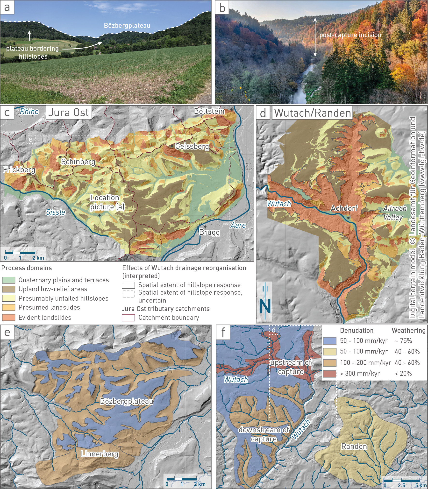
Fig. 6‑23:Comparison of a geomorphically quiet (JO) with a highly active landscape (Wutach)
Comparison of the study areas. (a) Field picture of a valley carved into the Bözbergplateau. Note the relatively straight mountain tops of the plateau. (b) Field picture of the narrow Wutach gorge cut into Muschelkalk carbonates after the river capture event ~ 18'000 years ago. (c) Map of (hillslope) process domains for the JO study area (Ludwig 2018; see details there for definition and criteria of individual process classes). (d) Map of (hillslope) process domains for the Wutach catchment around Achdorf (digital elevation model: LGL 2010). (e) Simplified synthesis of interpreted denudation rates based on basin-wide and hillslope sampling of cosmogenic nuclides of the Bözberg area. (f) Interpreted denudation rates of the Wutach and Randen area. The colours also indicate the approximate percentage of weathering contributing to the total denudation rate (Fig. 6‑23a, b, e, and f are courtesy of R. Ott, see also Nagra 2024k).
The names "Donau-Wutach" and "Rhine-Wutach" are adopted from Einsele & Ricken (1995). Donau = Danube. ↩
In the Bözberg region, two 36Cl samples of amalgamated colluvium from the bottom of two hillslopes were collected for comparison with nearby streams. ↩