
All currently available data suggest that Northern Switzerland can be considered as an area characterised by low geodetic velocities. While the focus of the previous section was on vertical crustal motion (as a driver for erosion), this section highlights two additional datasets that provide evidence for ongoing tectonic activity in Northern Switzerland: (i) GNSS measurements at permanent stations, and (ii) the present-day earthquake distribution suggesting activity along major faults. The regions that record active deformation on multi-decadal timescales are the Upper Rhine Graben, the Hegau – Bodensee Graben and the Jura Fold-and-Thrust Belt.
Global navigation satellite system (GNSS)
Precise positioning measurements using permanently installed stations are used to monitor present-day motion (vertical and horizontal) at the Earth’s surface. Such a network of permanent stations also exists in Switzerland and has been densified in Northern Switzerland (Nagra 2024l). It is observed that, in particular in the early time after installation, the stations are characterised by higher velocities which are probably related to artefacts. Stations with longer monitoring periods show more stable velocity fields (Nagra 2024l). Generally, the resolution for horizontal motion is difficult to quantify, but inferred to be close to 0.1 mm/yr or below (e.g. Fig. 6‑8).
For a tectonic interpretation of the permanent stations located in Northern Switzerland, the horizontal motion is calculated in reference to stable Europe (Nagra 2024l). In general, horizontal velocity of the stations reveals a motion towards the NNE (Fig. 6‑8). No differential movements above the general noise level between neighbouring stations are detectable. Thus, no significant tectonic activity above the detection limit or referable to specific regional faults can be detected via GNSS. The data are thus averaged over the entire Northern Switzerland to constrain average velocity anticipated to occur in the future.
To do so, the horizontal velocity vector from each permanent station is subdivided into a north component and an east component (Fig. 6‑9). The east component is low, generally below 0.2 mm/yr for the considered stations. The north component is around 0.4 mm/yr. A slight decrease in the north component is observed in more northerly stationsFig. 6‑10. The weak linear regression (Pearson’s r = -0.30) indicates 1.4 × 10⁻⁹ ± 0.8 × 10⁻⁹ yr-1 shortening or 1.4 ± 0.8 m/km/Myr (Nagra 2024l). The shortening amounts to 2.8 × 10⁻⁹ ± 0.9 × 10⁻⁹ yr-1 if only the stations around the siting regions, which were built with focus on detecting potential tectonic activity (red in Fig. 6‑9, Pearson’s r = -0.71), are considered. This estimate is subject to substantial uncertainties and thus only serves for an order of magnitude estimation. The inferred strain rate agrees well with published data for Northern Switzerland also based on GNSS movements and is indicative for low rates of horizontal motion for Northern Switzerland (Sánchez et al. 2018, Houlié et al. 2018, Rabin et al. 2018, Piña‐Valdés et al. 2022, Serpelloni et al. 2022). A very weak linear regression (Pearson’s r = 0.03) indicates 0.1 × 10⁻⁹ ± 0.6 × 10⁻⁹ yr-1 E-W directed extension (Nagra 2024l). It should be noted that the E-W directed trend with respect to station position along strike of the Alpes is not statistically robust but serves as estimate of order of magnitude. All recorded rates using GNSS are significantly lower than the typical time-averaged bulk strain rates in an orogen of 3 × 10⁻⁷ yr-1 as proposed by Fagereng & Biggs (2019). Therefore, it is concluded that Northern Switzerland is currently deforming at low rates.
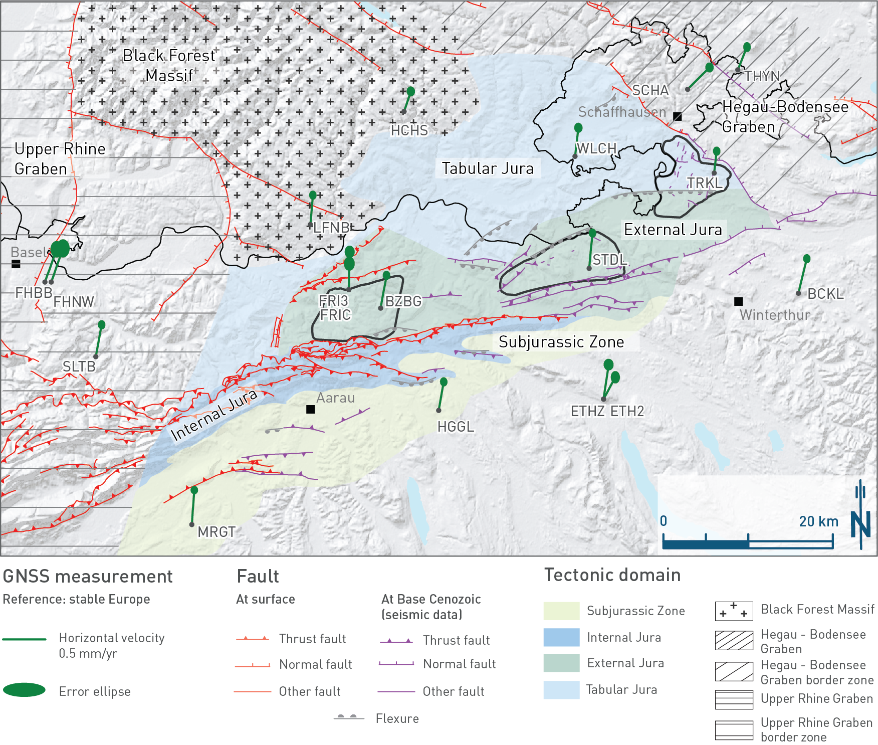
Fig. 6‑8:Present-day horizontal motion of permanent GNSS stations in Northern Switzerland
Results are calculated in reference to the ETRF 2014 (i.e. relative to stable Europe representing a combination of the stations GRAS (Austria), JOZE (Poland), METS (Finland), ONSA (Sweden), POTS (Germany), WTZR (Germany), YEBE (Spain) and ZIMM (Switzerland). Stations with two vectors (ETHZ, ETH2, FRI3, FRIC) have two antennas at close distance. Fault inventory shows traces of faults mapped at the surface (red) or on Base Cenozoic (violet). Note that only a selection of the structures from 3D seismic interpretation is shown to highlight the structural trends of regional importance. These were projected from Top Villigen Formation to Base Cenozoic.
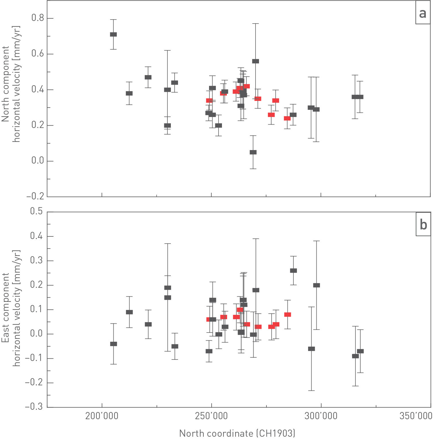
Fig. 6‑9:Horizontal velocity components deduced from repeated GNSS measurements
Stations are located over approximately 120 km north-south and 200 km east-west extent centred over Northern Switzerland. (a) North component of horizontal velocity vector plotted against the north coordinate of the station. (b) East component of horizontal velocity vector plotted against the north coordinate of the station. Results are in reference to the ETRF 2014 (i.e. relative to stable Europe representing a combination of the stations GRAS (Austria), JOZE (Poland), METS (Finland), ONSA (Sweden), POTS (Germany), WTZR (Germany), YEBE (Spain) and ZIMM (Switzerland)). Red-labelled stations are NaGNet stations, whereas black-labelled stations are AGNES stations (AGNES: Automated GNSS Network for Switzerland). Stations are shown in Fig. 6‑8. Stations with two vectors (ETHZ and ETH2, FRI3 and FRIC) have two antennas close-by.
Seismicity
Switzerland has a well-documented historical record of seismicity, which dates back several hundred years for felt seismicity (Fäh et al. 2011). The density of seismic stations was gradually increased over the past decades and now allows to determine earthquakes with magnitudes below 1.5 nearly everywhere in Switzerland and magnitudes even below 0.75 in the area comprising the siting regions (Nagra 2024l). Although earthquakes have been recorded in the area close to the siting regions, Northern Switzerland is one of the areas of lowest determined seismicity within the country (Fig. 6‑10).
The largest known historical earthquake in the vicinity of the siting regions, located at the overlap between the Jura Fold-and-Thrust Belt and the Upper Rhine Graben, is the Mw 6.6 Basel earthquake in the year 1356 (Bakun & Scotti 2006, Fäh et al. 2011). Other historical and instrumentally recorded events had significantly smaller magnitudes (Fig. 6‑10). The spatial distribution of seismicity in Northern Switzerland can be loosely correlated with the occurrence of the large tectonic domains. For example, the area around Basel with a comparatively higher level of seismicity is located in the Upper Rhine Graben (Fig. 6‑10, see Section 4.3.3). Earthquakes in the Upper Rhine Graben have focal mechanisms typically indicating transtensional deformation (Fig. 6‑10). Similarly, the Hegau – Bodensee Graben, which extends from the Bodensee to the NW (see Section 4.3.3), is characterised by increased present-day seismicity (Kahneman et al. 1982). Focal mechanisms of a series of earthquakes occurring between 2014 and 2019 located along the Neuhausen Fault within the Hegau – Bodensee Graben are characterised by predominant normal faulting (Fig. 6‑10; see Diehl et al. 2023 and Nagra 2024l for more detail).
In the Jura Fold-and-Thrust Belt seismicity is concentrated in the central to western parts but is indicative of ongoing deformation in the Internal Jura (e.g. Lanza et al. 2022). Between these tectonic domains, seismicity in Northern Switzerland is sparse and earthquake hypocentres are distributed throughout the entire upper crust. A cluster of shallow, low-magnitude events occurs near the city of Eglisau (Fig. 6‑10; see Nagra 2024l).
Glacial isostatic adjustment is known to influence not only the vertical surface velocities but also the horizontal velocity field. These effects are not only seen in the immediate vicinity of the glacial load, but also at long distances away (e.g. Grollimund et al. 2001), hence phases of increased fault activity need to be considered in association with glacial cycles, especially for a prolonged period following deglaciation. While glacial isostatic adjustment can perturb the overall stress field and thus inhibit or trigger faulting (e.g. Hetzel & Hampel 2005, Craig et al. 2016), it is unlikely that glacial isostatic adjustment alone is responsible for fault failure especially at a distance from the ice load (Craig et al. 2023).
Taking these considerations into account, it can be concluded that the timing of seismicity in Northern Switzerland might be predominantly caused by transient non-tectonic stress perturbations (e.g. related to glacial isostatic adjustment), while the overall mechanism of strain release follows the elastic long-term tectonic strain stored in the lithosphere. This tectonic strain is expected to be released along the pre-existing (regional) faults, as such faults have been repeatedly reactivated during the tectonic evolution (Section 4.3). In conclusion, Northern Switzerland is considered as tectonically active, but it is a low-strain area (see Nagra 2024l).
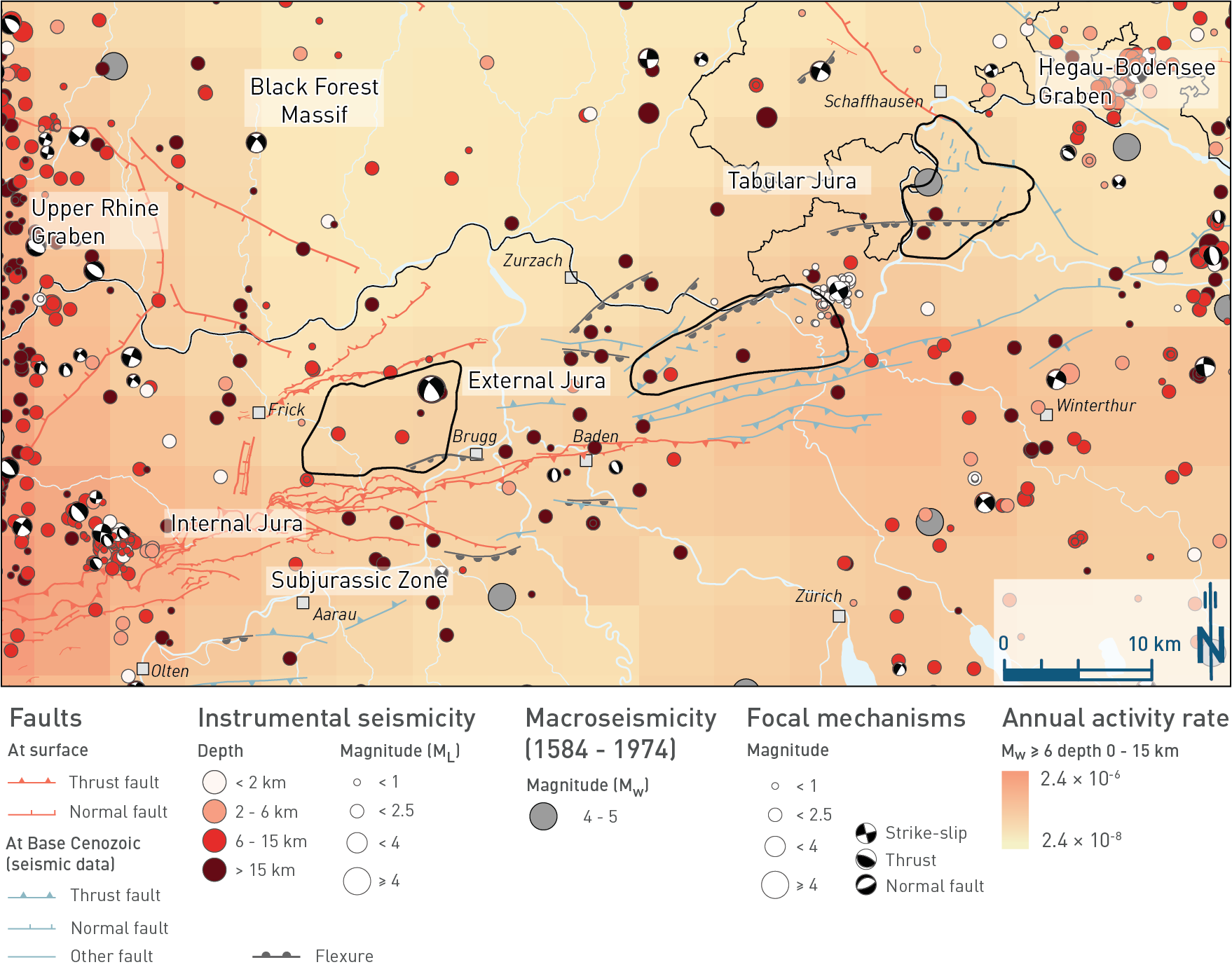
Fig. 6‑10:Distribution of earthquakes and selected focal mechanisms
Recorded earthquakes (historical and instrumental) and modelled probability of earthquakes with Mw ≥ 6 occurring in Switzerland, determined within the framework of the PRP project (swissnuclear 2013). The background colour indicates the annual probability of occurrence for earthquakes with Mw ≥ 6 in an area of 0.05° longitude × 0.05° latitude (ca. 21 km2) for hypocentral depths < 15 km. Seismicity is based on different catalogues: historical data prior to 1975 (Fäh et al. 2011) and instrumental data between 1975 and October 2023 (merged catalogue with data until 2023/10/03, including Swiss Instrumental Network, absolute re-localised events (following Diehl et al. 2021) and regional analyses of selected earthquake clusters; courtesy of T. Diehl). Focal mechanisms are shown for selected events of the instrumental catalogue. Note that only a selection of the structures from 3D seismic interpretation is shown to highlight the structural trends of regional importance. These were projected from Top Villigen Formation to Base Cenozoic.