
Given the known process rates and the geological and geomorphological characteristics of the siting regions, it is expected that future tectonic and climatic forcing will drive fault movement and surface processes (Fig. 6‑2) in Northern Switzerland, and the potential impact of these must be accounted for. This section provides an overview of the relevant processes, process interactions, and feedback to be expected in Northern Switzerland.
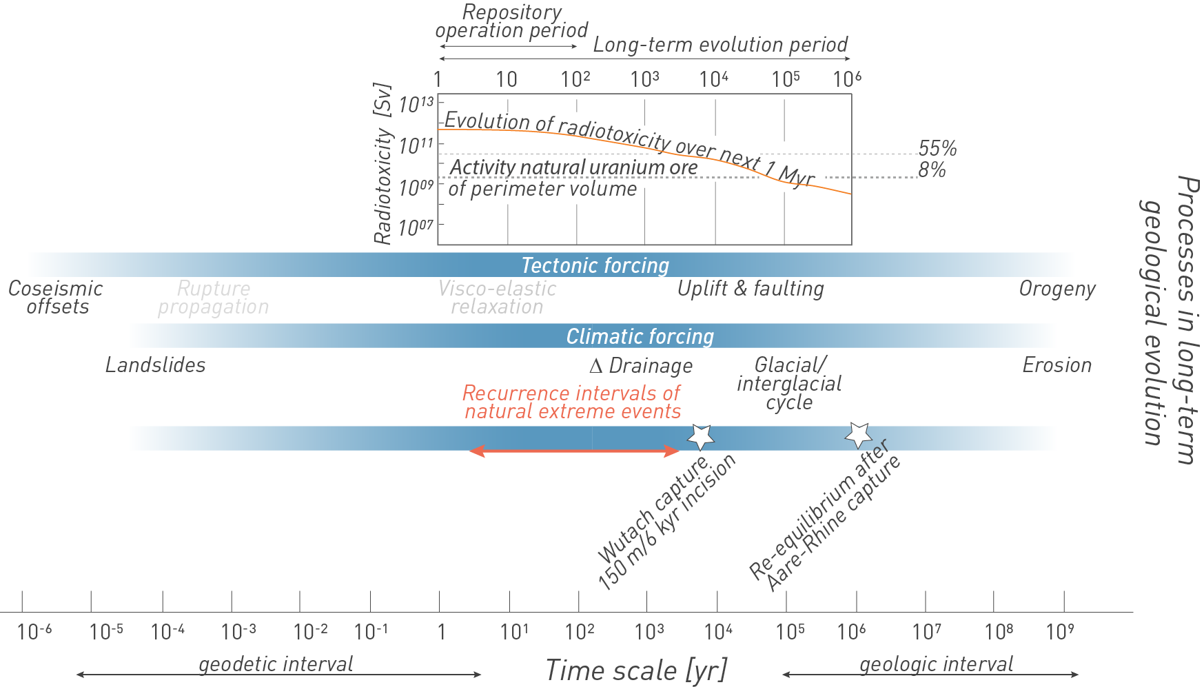
Fig. 6‑2:Geological processes acting at different timescales compared with the time period relevant for repository safety
The geology and geomorphology in the vicinity of the repository are expected to be subjected to tectonic and climatic forcing that drive erosional processes or fault motion that could potentially affect the stability of the geological barrier. Given the period under consideration of one million years for HLW (see figure above), several of these processes need to be addressed. Note the log-scale for the time of observation. Radiotoxicity is based on the Swiss waste inventory and is a measure that allows the comparison between radioactive waste and natural rock compositions, such as U-rich (Cigar Lake [8%], La Creusaz [55%]) rock types, assuming a similar volume as the HLW waste in their perimeter of tunnels and caverns (see Nagra 2024d). Also indicated are two examples of geomorphic events that have influenced the process rates in Northern Switzerland on different timescales: the capture of the Wutach River resulted in strong incision of which the majority of up to 150 m may have occurred during the first approximately six thousand years after the capture (Einsele & Ricken 1995). The reorganisation of the Aare – Rhine Rivers impacted Northern Switzerland regionally. Re-equilibrium of the drainage system to a capture ~ 4.2 Ma ago was modelled to take approximately one million years.
Tectonic and climatic drivers act on a variety of timescales (Fig. 6‑2), with short timescale events such as earthquakes or extreme climate-driven meteorological events, whether instrumentally or historically recorded, rarely being a good proxy for long-term behaviour. Conversely, studies that focus solely on geological archives and landforms on scales of 105 to 106 yr are often not precise enough to resolve discrete fault behaviour or to decipher the landscape response to climatic forcing. Therefore, earthquake and climate impact studies need to be integrated across multiple timescales, and observations extended to longer timescales spanning several thousand years to one million years to account for the potential future behaviour of different forcing factors that could reduce the efficiency of the geological barrier.
Consequently, any changes in topography and relief due to vertical crustal movements and superimposed climate-driven changes in a tectonically active region will influence the form and rate of erosion processes. Thus, tectonic and climate-driven processes need to be identified, classified, and rated with respect to their relevance, timing, location, and potential impact on the geological barrier function. In the light of these considerations, the specific forcing factors that have determined, and will continue to influence, the long-term geological evolution of Northern Switzerland involve low-strain tectonic processes, climate change, and protracted erosion (see Fig. 6‑1). Taken together, these three components may influence the hydrogeology and geochemistry of the host rock and confining units, as explained below:
Tectonic evolution based on the present-day geodynamic configuration of the Alpine realm is expected to influence vertical and horizontal motion in the region. On a large scale, tectonic processes such as rock uplift of the Alpine Foreland and subsidence of the southern Upper Rhine Graben play an important role as they build topography and drive fluvial incision and denudation. Because the resulting erosion reduces the overburden thickness above the repository, the rates and patterns of such regional vertical motion have been assessed (see Section 6.2). Large-scale geodynamic processes, on geological timescales of millions of years (Chapter 3, Section 4.3), determine the orientation and magnitude of the regional tectonic stress regime, which might be altered on much shorter timescales by transient perturbations. These perturbations may, for instance, involve either lithospheric flexure because of regional loading and unloading during glacial advances and retreat or hydro-isostasy. Such processes can affect the aquifer flow system or hydraulic gradients (see Section 6.5), but they may also unclamp locked faults through the erosional reduction of normal stresses and trigger earthquakes with very long recurrence intervals (see Section 6.2.3).
Northern Switzerland is adjacent to a region where mantle-driven processes are responsible for magmatic activity and associated processes. Two of the closest centres of volcanic activity to Northern Switzerland are the Kaiserstuhl and Hegau Graben eruption centres in southern Germany. Volcanism at the Kaiserstuhl eruption centre occurred between ~ 21 and 13 million years ago, while volcanic activity in the neighbouring Hegau region ceased in the Late Miocene (Geyer et al. 2023). There has been no magmatic activity in Northern Switzerland for at least the last 5 million years (Schreiner 1992, Ibele 2015). Considering the current characteristics of the region, there are no indicators for dormant volcanic activity in Northern Switzerland, in contrast e.g. to the Eifel region in Germany. Seismicity in Northern Switzerland reflects low-rate tectonism (Diehl et al. 2023) with no documented volcanic tremors. Thus, volcanism in Northern Switzerland is considered very unlikely within the next one million years and is therefore of no concern and is not considered further here.
A characterisation of expected seismic or aseismic fault slip (see Section 6.2.3) is important to assess hydraulic changes and potential flow along faults in the low-permeability sequence. No relevant effects of seismic shaking on the integrity of the deep geological repository are expected because of the deep subsurface repository position and backfill (see Nagra 2024i). Seismic hazard during the operational phase is taken into account in the operational safety report (see Nagra 2024h and Nagra 2024g).
In this chapter, information is provided to answer the following questions:
-
What uplift rates can be expected in the siting regions over the next 100'000 to one million years?
-
What vertical motion is expected downstream and upstream of the siting regions along the main rivers, which may in turn influence future river incision?
-
Where and to what extent is movement along faults possible?
Climate evolution in the northern sector of the Alpine region is expected to be influenced by recurring and protracted changes in the Earth’s orbit and tilt, which has had a major influence on landscape evolution during Pleistocene glacial/interglacial cycles. Because of the recurrent nature of these forcing mechanisms, they are expected to continue to exert this influence in the future. In particular, the change from a predominant ~ 41-kyr cycle to the establishment of a 100-kyr-long cycle during the Mid-Pleistocene Transition (MPT) fundamentally impacted erosional and sedimentary processes and thus Quaternary landscape evolution in Northern Switzerland (see Section 6.4.1). This cyclicity modulates climate parameters such as temperature and precipitation, which in turn influence water and sediment discharge as well as the overall hydrogeological evolution in the subsurface.
The greatest past climate impact on the landscape was associated with Pleistocene glacial periods (see Section 6.3). Extensive foreland glaciations can change sediment routing, deposition and drainage pathways or erode overdeepened valleys. In Northern Switzerland, it is expected that long durations of extensive foreland glaciations can, for example, cause lithospheric depression in the North Alpine Foreland along with transient stress changes that could influence the seismogenic behaviour of inherited faults (see Section 6.2.4). Typically, postglacial rebound follows an exponential trend until isostatic equilibrium is restored. During this period, higher uplift rates and associated stronger fluvial incision can be expected (see Section 6.4.3.1). In addition, mechanical loading and compaction by the ice cover, as well as subglacial infiltration, are likely to impact the hydraulic system. Extensive foreland glaciations may be accompanied by deep-reaching permafrost, which might affect aquifers by groundwater freezing and increase hydraulic heads and/or change groundwater flow paths (see Section 6.5.1.3).
Questions to be answered with respect to climate forcing are:
-
What timing and extent of future glaciations in Northern Switzerland might be expected, considering natural conditions and potential effects of anthropogenic CO2 emissions?
-
What ice thicknesses and duration of ice occupation are expected during future glaciations considering Pleistocene examples?
-
To what depth could the subsurface be frozen during future ice ages (permafrost)?
Erosion is mainly driven by the effects of tectonic and climatic processes, as outlined above and illustrated in Fig. 6‑2. In the area of the selected repository siting regions in Northern Switzerland, these processes may be characterised by slow vertical tectonic movements and glacial influences. The latter may involve significant erosional lag times between ice loading, topographic change, and deglaciation, as well as rate changes during isostatic readjustments. Ultimately, it is the synergistic interaction between long-term tectonic processes that build topography on the one hand and superimposed surface processes that are influenced by climate and vegetation cover on the other that sculpt landscapes (e.g. Burbank & Anderson 2012). The landscape of the three siting regions in Northern Switzerland has been primarily shaped by the stepwise fluvial incision of the Aare and Rhine Rivers, the evolution of a low-relief cuesta landscape, and repeated deep glacial erosion and depositional processes determined by the glaciations of the Alpine Foreland. Accordingly, the main drivers for these processes are the effects of glacial/interglacial cycles and long-term rock uplift associated with the vertical motion of the Alpine orogen and its foreland. However, the process rates are low in a global context and compared to seismically active plate-boundary settings.
To assess erosion with respect to the performance and long-term safety of the future repository, the following questions will be answered:
-
To what extent will the overburden thickness be reduced at the repository sites? The answer to this question needs the following sub-questions to be addressed:
-
How will the fluvial system evolve? How much incision is expected during the period under consideration? Will the host rock and confining units remain below the local baselevel?
-
How will the morphology around the repository evolve with regard to recharge and discharge areas?
-
How deep could future glacial erosion reach at the location of the future repository?
-
The cascade of driving forces outlined above leads to changes in the future landscape that also affect the hydrogeology and hydrochemistry in the rock column. Hydrogeological changes in areas subjected to multiple glaciations and tectonic uplift can be significant and the effects on the stability of the geological barrier are thus analysed in this regard. In hydrogeological systems, a geological barrier is typically subdivided into the host rock, the low-permeability confining units, and the surrounding deep aquifer systems. Not only do tectonic movements, climate change, and climate-driven surface processes (erosion) affect the recharge and discharge paths and gradients in deep aquifer systems, they can also impact the gradients in the low-permeability units. As a result of its high clay-mineral content (self-sealing capacity; Section 5.7) and low permeability (Section 5.6), there tends to be little impact of tectonics or erosion on transport in the Opalinus Clay. However, if overburden thickness decreases drastically because of erosion, decompaction effects may lead to less efficient self-sealing (Section 5.7), increased porosity and permeability (Section 5.6), and a change in host rock mineralogy and porewater chemistry.
The following main questions concerning the influences of tectonics, climate and erosion on the hydrogeology and barrier performance and thus the long-term safety of the future repository will be addressed:
-
How could the dynamics in the deep aquifers evolve (flow velocity, flow direction, discharge paths)?
-
Are the gradients across and along the low-permeability sequence (host rock and confining units) expected to change in a relevant way?
-
What are the expected effects of the possible fault-slip scenarios?
-
Will transport across the low-permeability units remain diffusion-dominated? Do diffusion and sorption properties change in a significant way?
-
How might the porewater composition change in future and how might this impact diffusion and sorption of radionuclides?