
A) Hydrogeochemical characterisation and groundwater origin
Groundwater samples from the Muschelkalk aquifer in Northern Switzerland and adjacent areas display very large variations in their composition, with TDS concentrations ranging from 0.5 to 156 g/L (Fig. 4‑112). Groundwaters with TDS concentrations above 8 g/L are of Na-Cl type. If the TDS concentration is between 2 and 8 g/L, groundwaters are mainly of Ca-SO4 type. Exceptions are the thermal waters of the Baden/Ennetbaden and Schinznach Bad groups and the groundwater from the Schlattingen-2 borehole (SLA2), which are of [Na/Ca]-[SO4/Cl] type. Groundwaters with TDS concentrations below 2 g/L are of Ca-HCO3 or Ca-[Mg]-[HCO3/SO4] type.
All groundwaters plot on or close to the 1:1 correlation between the concentrations of alkaline earth metal cations (Ca2+ + Mg2+) and SO42- (Fig. 4‑112). This indicates that Ca and SO4 are mainly inherited from the dissolution of gypsum in the recharge areas and anhydrite at greater depth in the aquifer (Section 4.5.3), resulting in a typical dedolomitisation scenario where gypsum/anhydrite and dolomite (CaMg(CO3)2) dissolve while calcite precipitates. Consequently, the Muschelkalk groundwaters are at, or are close to, saturation with respect to calcite, dolomite and gypsum/anhydrite.
Compared to seawater, the Na-Cl type groundwaters display an excess of Cl over Br and hence strongly deviate from the seawater dilution line (Fig. 4‑112). In addition, the groundwater collected in the BUL1 borehole displays a TDS concentration of 145 g/L, strongly exceeding that of seawater (Fig. 4‑112). These observations demonstrate that the Na-Cl signature is because of the dissolution of halite occurring in the Zeglingen Formation, ca. 100 m below the Muschelkalk aquifer (Section 4.2) and not from a seawater-like water component such as described above for the Malm aquifer. This is consistent with the observation that, in terms of stable water isotopes, all Muschelkalk groundwaters plot on or very close to the GMWL, confirming the meteoric origin of these groundwaters (Fig. 4‑112).
The different water types are also reflected in groundwater residence times inferred from 3H and 14C activities. The Ca-HCO3 and Ca-[Mg]-[HCO3/SO4] type groundwaters are 3H-bearing and show 14C activities generally above 15 pmC (Fig. 4‑112), suggesting that meteoric water recharge occurred in the recent past. This is consistent with the signature of stable isotopes in these groundwaters, which fall within the range of meteoric water for today’s climatic conditions (Fig. 4‑112). Most of the Ca-SO4, [Na/Ca]-[SO4/Cl] and Na-Cl type groundwaters show corrected 14C activities below 15 pmC. In the case of the groundwater sample from STA2, it is below detection. This is consistent with δ18O values below -11 ‰ of groundwaters collected in the ZNO and NL siting regions, indicating that meteoric water recharge occurred during a cold glacial period (Fig. 4‑113). It follows that, in these two siting regions, Muschelkalk groundwaters infiltrated during the last glacial cycle (i.e. 12 – 115 kyr ago; Schlüchter et al. 2021).
Helium analyses are available for the Ca-SO4, [Na/Ca]-[SO4/Cl] and Na-Cl type groundwaters. The Ca-SO4 type groundwaters show 4He concentrations ranging from 10-7 to 10-5 ccSTP/g (Fig. 4‑112). In groundwaters of the other two types ([Na/Ca]-[SO4/Cl] and Na-Cl), 4He concentrations are up to two orders of magnitude higher, with the highest concentration being measured at BOZ2. In terms of 3He/4He ratios, all groundwaters from the three siting regions show elevated values above those of the Mesozoic sedimentary rocks, indicating the presence of a few percent of mantle-derived He.
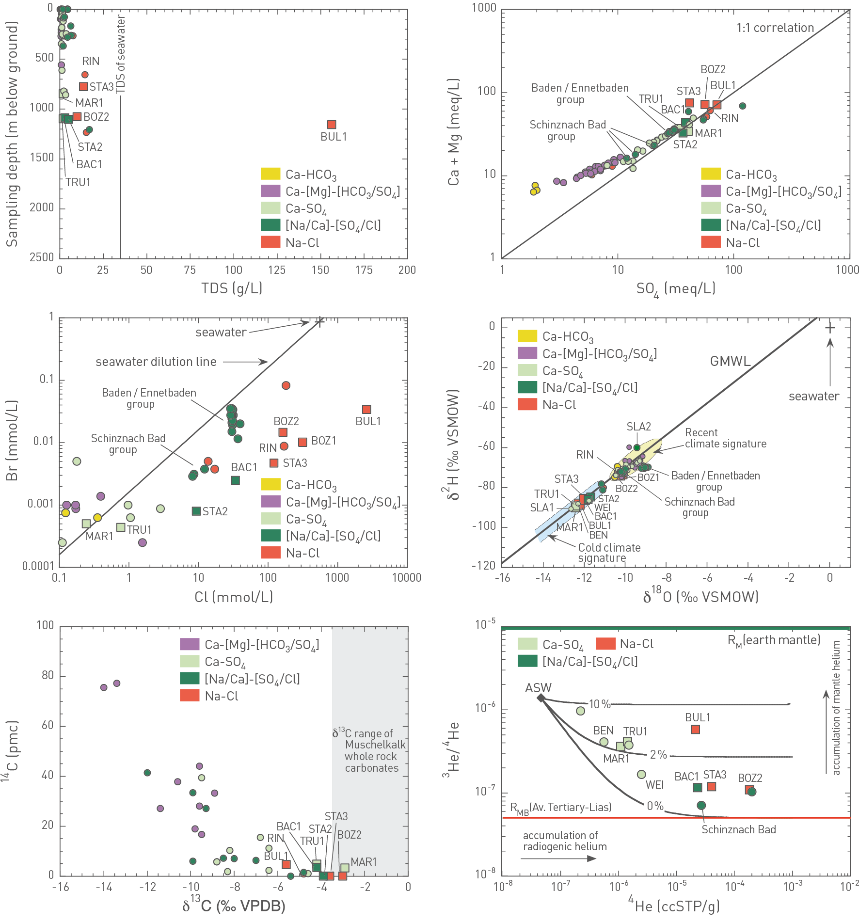
Fig. 4‑112:Cross-plots illustrating the behaviour of key hydrogeochemical parameters in groundwaters collected from the Muschelkalk aquifer in Northern Switzerland and Southern Germany
Filled circle and square symbols represent samples reported in Waber & Traber (2022) and collected during the TBO campaign, respectively. Sampling locations are only provided for the samples collected in the three siting regions as well as those from the Baden and Bad Schinznach geothermal areas to emphasise that these all relate to [Na/Ca]-[SO4/Cl] type groundwaters. Samples from hydrocarbon exploration wells in the central Molasse Basin have limited datasets and are not shown. 14C activities are corrected for drilling mud contamination and other sampling artefacts. RMB: average 3He/4He production ratio of Molasse to Lias Group sedimentary rocks in the Swiss Molasse Basin. ASW: air-saturated water (Kipfer et al. 2002). Black lines in the He-plot indicate the behaviour of hypothetical mixtures between ASW and RMB as well as different proportions of mantle helium (RM).
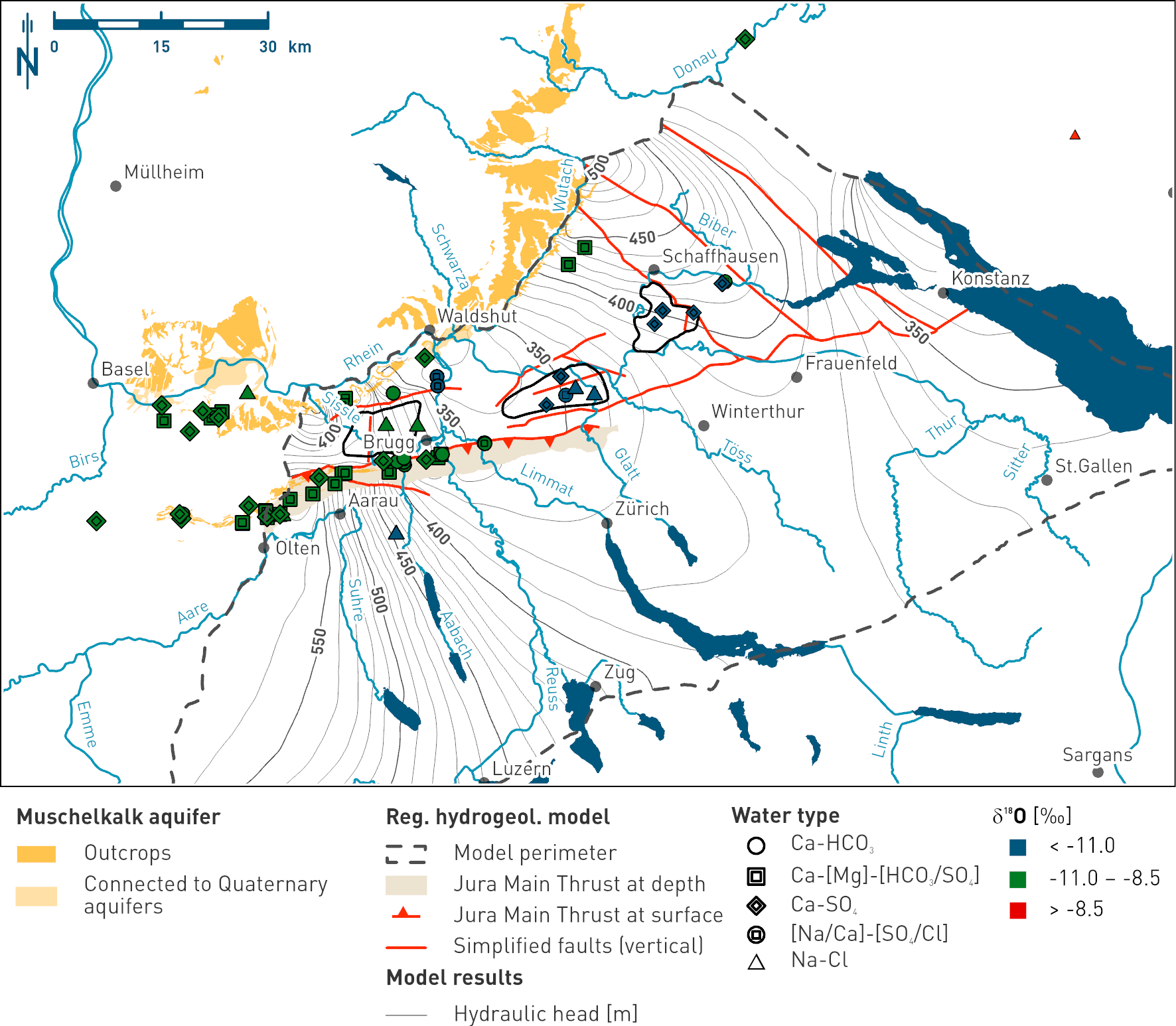
Fig. 4‑113:Map showing the spatial distribution of δ18O values in groundwaters collected from the Muschelkalk aquifer as indication of the recharge conditions of the different water types
The symbols represent the water types while the colour of the fillings indicates the δ18O value range of the samples (see legend). The data range of δ18O of -11.0 to -8.5 ‰ VSMOW is representative for recent groundwaters of the region. Green colour denotes groundwater formed during climatic conditions similar as today in the study area. Groundwater samples marked in blue formed under cold climatic conditions. The map also shows the outcrops of the Muschelkalk aquifer, a simplified regional fault pattern and the hydraulic head isolines according to the regional hydrogeological model (Section 4.5.4.5).
B) Regional groundwater evolution
The different hydrogeochemical signatures of the Muschelkalk groundwaters in Northern Switzerland reflect different stages in their hydrogeochemical evolution. This is discussed below for the three major groups of water types.
Ca-HCO3 and Ca-[Mg]-[HCO3/SO4] type groundwaters: Shallow groundwaters close to outcrops
In Northern Switzerland, Ca-HCO3 and Ca-[Mg]-[HCO3/SO4] type groundwaters occur at relatively shallow depths where the Muschelkalk units outcrop at the surface or where they are in contact with Quaternary gravel aquifers such as at the southern margin of the Black Forest or north of the Aare River in the Jura Mountains (Fig. 4‑113). They represent the first stage of the hydrogeochemical evolution when meteoric water infiltrates into the Muschelkalk aquifer. This is consistent with their short residence times inferred from 3He and 14C activities as well as their δ18O signatures, which fall within the range of meteoric water infiltrating under similar climatic conditions to today (Fig. 4‑112). High recharge rates through the Muschelkalk outcrops and the high solubility of gypsum probably lead to a depletion of gypsum with time. Accordingly, these groundwaters deviate from the 1:1 correlation between alkaline earth metal cations (Ca2+ + Mg2+) and SO42- (Fig. 4‑112), and their chemical composition is mainly controlled by the dissolution of calcite and dolomite with a variable contribution from the dissolution of gypsum or anhydrite.
Ca-SO4 and [Na/Ca]-[SO4/Cl] type groundwaters: ZNO and NL siting regions
Compared to the Ca-HCO3 and Ca-[Mg]-[HCO3/SO4] type groundwaters, the chemical composition of Ca-SO4 groundwaters is more strongly controlled by the dissolution of anhydrite/ gypsum and dolomite as well as the precipitation of calcite as manifested by the 1:1 correlation of alkaline earth metal cations (Ca2+ + Mg2+) and SO42- (Fig. 4‑112). They represent a more evolved state, which is consistent with their lower 14C activity and less negative 13C values, indicating more carbon isotope exchange with Muschelkalk carbonates (Fig. 4‑112). Stable isotope ratios in Ca-SO4 and [Na/Ca]-[SO4/Cl] type groundwaters from the ZNO and NL siting regions show strong linear correlations with a series of other hydrogeochemical parameters including 81Kr model ages, 87Sr/86Sr ratios, as well as Li and Cl concentrations (Fig. 4‑114). Accordingly, they imply that the Muschelkalk groundwaters in the ZNO and NL siting regions represent a mixture of at least two components:
-
A younger meteoric water component of Ca-SO4 type characterised by δ18O values below -12.5 ‰ typical for cold climatic recharge conditions, non-radiogenic 87Sr/86Sr ratios below 0.7083 and Li and Cl concentrations below 0.2 and 5 mmol/L, respectively. This is the major component (> 80%).
-
An older meteoric water component of Na-Cl type characterised by δ18O values above ca. -9 ‰, radiogenic 87Sr/86Sr ratios above 0.7150 and higher Li and Cl concentrations than the meteoric water component described above (i.e. above 0.2 and 5 mmol/L, respectively).
The second component may indicate a contribution from deeper aquifers, e.g. a groundwater similar to the WEI sample from the crystalline basement (Fig. 4‑114). This component may i) still ascend along faults or ii) be present in the matrix porewater with an origin related to earlier cross-formation flow under different geodynamic conditions (Fig. 4‑115). Note that similar observations have previously been used to postulate upwelling of groundwater from the crystalline basement into the Muschelkalk aquifer north of the Bodensee (Stober et al. 2023) and that, in the two Schlattingen (SLA1 and SLA2) boreholes, the sample from close to the Randen Fault
indicates higher δ18O and chloride as well. It is important to note here that the most mineralised groundwater from BUL1 (Na-Cl type) is affected by salt dissolution but is devoid of particular indications of a basement component (see separate discussion below).
The mixing model discussed above is fully consistent with the regional hydrogeological model for the Muschelkalk aquifer in the ZNO and NL siting regions. Fig. 4‑116 shows that δ18O values increase with increasing distance from the Muschelkalk outcrops along the SE margin of the Black Forest in Southern Germany (e.g. Wutach Valley) probably operating as the main recharge location of the younger meteoric water component. Based on their linear correlations with δ18O values (Fig. 4‑114), the same applies to the 81Kr model ages, the 87Sr/86Sr ratios and the concentrations of Li and Cl. The proportion of the younger meteoric water component decreases along the groundwater flow path inferred from the regional hydraulic flow model (Fig. 4‑116). In contrast, the proportion of the older meteoric water component increases, although in most cases it never reaches more than a few percent based on the correlations shown in Fig. 4‑114. The strong spatial control of the proportion of the two water components demonstrates that the Muschelkalk aquifer in the ZNO and NL siting regions represents a large and regionally well-connected aquifer. This is in strong contrast to the other deep aquifers such as the Malm aquifer where the flow rates are much slower and almost stagnant conditions prevail. The differences occur because the transmissivity of the Muschelkalk aquifer is higher (Fig. 4‑86). In addition, the hydraulic head gradient is higher because the Muschelkalk outcrops on the southern margin of the Black Forest occur at a higher altitude than those of the Malm aquifer (Fig. 4‑105 vs. Fig. 4‑113).
While 14C activities, 81Kr model ages and δ18O values are fully consistent with recharge of the younger meteoric water component during the last glaciation period (12 – 115 kyr), the residence time of the older meteoric water component is less constrained. Based on the inferred endmember δ18O value around -8.5 ‰ indicating climatic conditions similar to today and the increase in 81Kr model ages with increasing contribution of this water component, the corresponding minimum residence time relates to the previous Eemian interglacial period some 115 – 130 kyr ago (Preusser et al. 2011). However, the residence time of this water component could be much higher. Unfortunately, there are no 81Kr analyses available for the groundwaters from SLA2 and WEI to better constrain the residence time of this second, upwelling groundwater component. Also, it remains unclear whether the vertical connection between the Muschelkalk aquifer and the underlying crystalline units is still active today. Alternatively, the recharge of the younger meteoric water component during the last glaciation period (12 – 115 kyr ago) could have caused the displacement of the older one, which may have infiltrated into the Muschelkalk aquifer along deep-reaching faults a long time ago. Overall, the strong linear correlation between δ18O values and the 81Kr model ages (Fig. 4‑114) suggests that the older meteoric water component is Kr‑bearing and that the 81Kr model ages reflect the mean residence time of the mixture of the two components.
Na-Cl type groundwaters in NL siting region
The composition of Na-Cl type groundwaters in the NL siting region (particularly BUL1; Fig. 4‑112) is mainly controlled by the dissolution of halite (NaCl) locally occurring in the Zeglingen Formation, around 100 m below the Muschelkalk aquifer (Section 4.2). Such dissolution does not affect hydrogeochemical parameters other than the concentrations of Na and Cl and the Br/Cl ratio, thus these groundwaters have simply experienced an additional chemical process in comparison to the Ca-SO4 and [Na/Ca]-[SO4/Cl] type groundwaters described above. Their hydrogeochemical evolution, however, could be very similar. This is manifested in the ZNO and NL siting regions where the Na-Cl type groundwaters plot on the same correlations between δ18O and other hydrogeochemical parameters (Fig. 4‑114) and thus belong to the same regional flow system.
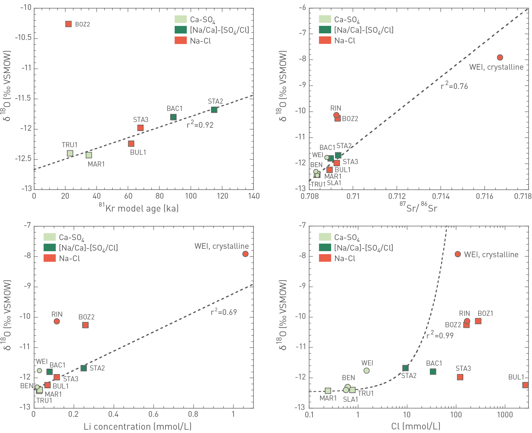
Fig. 4‑114:Correlations between δ18O values and selected other parameters of Muschelkalk groundwaters collected in the siting regions as well as comparison to a potential endmember of the mixing trend (WEI, crystalline)
Circle and square symbols represent samples reported in Waber & Traber (2022) and collected during the TBO campaign, respectively. The linear correlations, plotted as dashed lines, were derived using the samples collected during the TBO campaign in the NL and ZNO siting regions. For the δ18O vs. Cl correlation, the Na-Cl type Muschelkalk groundwaters were not used because they are affected by the local dissolution of halite. Also discarded was the [Na/Ca]-[SO4/Cl] type groundwater collected from the BAC1 borehole because it is also likely affected by local halite dissolution.
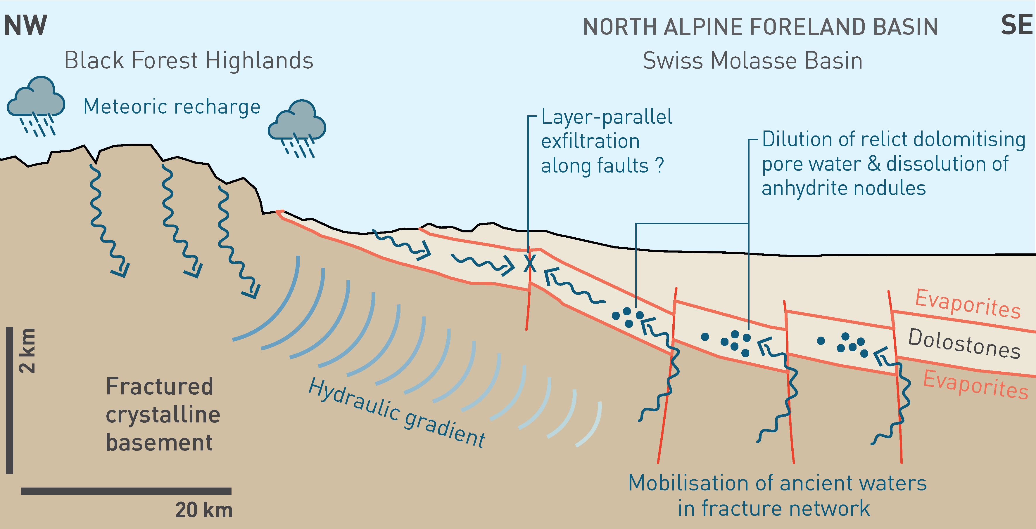
Fig. 4‑115:Sketch illustrating the upwelling of groundwater from the crystalline basement into the Muschelkalk aquifer along regional fault zones some 8 – 13 Myr ago
Modified from Aschwanden et al. (2019b).
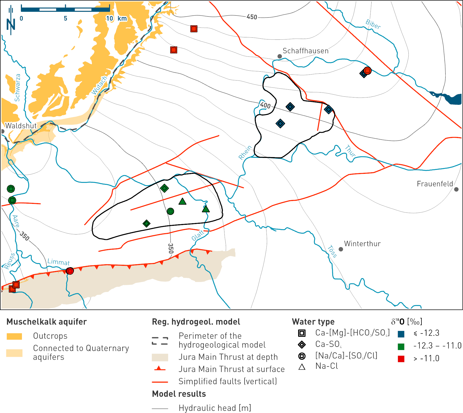
Fig. 4‑116:Map showing the distribution of the δ18O values in groundwaters of the Muschelkalk aquifer as manifestation of the regional groundwater flow system in the ZNO and NL siting regions
The general flow direction is illustrated in Fig. 4‑102. The symbols represent the water types while the colour of the fillings indicates the δ18O value range of the samples (note the different classes compared to Fig. 4‑113). The map illustrates the evolution from the particularly negative isotopic composition of the groundwater in the ZNO area to less negative values in NL (see text for details). The map also shows the Muschelkalk outcrops, a simplified regional fault pattern and the hydraulic head isolines according to the regional hydrogeological model (Section 4.5.4.5).
Na-Cl type groundwaters in the JO siting region
All groundwaters from the JO siting region are of Na-Cl type (Fig. 4‑112), which may be explained by a saline component reaching the Muschelkalk aquifer probably along the Jura Main Thrust south of the JO siting region. Based on strongly contrasting δ18O values and the lack of correlations with other chemical parameters plotted in Fig. 4‑114, they have probably experienced a contrasting hydrogeochemical evolution than the Muschelkalk groundwaters in the NL and ZNO siting regions. Hence, they do not belong to the same flow system as the one active in the ZNO and NL siting regions (Section 4.5.4.5) suggesting that, in the JO siting region, recharge occurs through the outcrops in the Jura Mountains to the south and not along the SE margin of the Black Forest as for the other two siting regions (Fig. 4‑113). In addition, based on the 81Kr and 14C model ages of the BOZ2 sample of less than 22 kyr and 14 kyr, respectively, also the mean groundwater residence time in the JO siting region may be quite different. Together with the δ18O value of around -10 ‰, these model ages point towards recharge occurring in the current Holocene interglacial period. Accordingly, the flow system in the Muschelkalk aquifer in the JO siting region may be more active than in the two other siting regions. This could be a result of the local tectonic setting (Section 4.3).
Summary of the Muschelkalk aquifer in the siting regions
In conclusion, the Muschelkalk aquifer in the ZNO and NL siting regions represents a regionally well-connected aquifer consisting of two main water components: (i) Ca-SO4 type groundwaters originating from meteoric water that infiltrated through the Muschelkalk outcrops along the SE margin of the Black Forest during the last glacial period (12 – 115 kyr) and a minor component of (ii) an older Na-Cl type groundwater of meteoric origin that upwelled into the Muschelkalk aquifer from the underlying crystalline basement along deep reaching faults (see discussion in following section). Locally, the dissolution of halite may lead to high concentrations of Na and Cl exceeding those of seawater; however, this is not necessarily related to cross-formation flow. In the JO siting region, the Muschelkalk aquifer belongs to a different, much more active hydraulic system where recharge probably occurred in the current interglacial period (< 12 kyr ago).