
A) Hydrogeochemical characterisation and groundwater origin
As a result of the facies change from the Hauptrogenstein in the west to the clay-mineral-rich Klingnau Formation in the east (Sections 4.2.7 and 4.5.3.6), the Hauptrogenstein aquifer is only relevant for the JO siting region and groundwater samples have only been obtained west of the Aare River (Fig. 4‑108). Their composition is variable, with TDS concentrations ranging from about 1 to about 11 g/L (Fig. 4‑109). Shallow groundwaters in the top 300 m are of the Ca-HCO3, Ca-Mg-HCO3 or Na-HCO3 type and show TDS concentrations below 1 g/L. In the investigated region, there are only two samples collected below 300 m. Both of them show much higher TDS concentrations of 5 and 11 g/L, respectively, and they are characterised as Na-SO4 or Na-Cl type groundwaters.
In the Br – Cl plot, the deep and saline Na-Cl and Na-SO4 type groundwaters plot on or close to the seawater dilution line (Fig. 4‑109). These groundwaters represent diluted seawater, which means that Na and Cl are of marine origin with an additional SO4 source for the Na-SO4 type groundwater collected at BOZ2 (see below). In the stable water isotope plot, Na-Cl and Na-SO4 type groundwaters are shifted slightly to the right of the GMWL (Fig. 4‑109), which is consistent with a non-meteoric origin. In contrast, the low-salinity groundwaters (i.e. Ca-HCO3, Ca-Mg-HCO3 or Na-HCO3 type waters) plot on the GMWL with values ranging between -11 and -9 ‰ typical for the infiltration of meteoric water under similar climatic conditions to today.
In the Na – Cl plot almost all groundwaters deviate from the seawater dilution line (Fig. 4‑109), indicating that Ca-exchange reactions with Na-rich clay minerals are relevant for almost all Hauptrogenstein groundwaters.
Information on the groundwater residence time is only available for the deep Na-SO4 type groundwater from BOZ2. While the sample is 14C-free, the derived 81Kr model age is 273 kyr. Such elevated residence times are consistent with the elevated 4He concentration of 2.33 × 10‑4 ccSTP/g.
B) Regional groundwater evolution
Similarly to the Malm aquifer, the different hydrogeochemical signatures of shallow and deep groundwaters reflect different stages in their hydrogeochemical evolution. While the shallow groundwaters of the Ca-HCO3, Ca-Mg-HCO3 or Na-HCO3 type are mainly controlled by the dissolution of carbonates and ion exchange reactions, the composition of deep Na-Cl and Na-SO4 type groundwaters is additionally affected by an ancient seawater component as well as a SO4 source and hence reflect more evolved groundwaters (Fig. 4‑109). With the limited dataset available for the Hauptrogenstein aquifer it is not possible to conclusively identify the origin of these additional components.
Based on their elevated residence time and the similar stable isotope shift to that observed for Na‑Cl type groundwaters from the Malm aquifer (Fig. 4‑109), the Na-Cl and Na-SO4 type groundwaters may have experienced a similar hydrogeochemical evolution. Thus, deep Hauptrogenstein groundwaters from the JO siting region may contain a diluted and isotopically modified seawater component such as discussed above for the Malm aquifer. Alternatively, high concentrations of Na, Cl and SO4 could be the result of a long-lasting exchange with porewater of the underlying aquitards. These porewaters are of marine origin and show higher concentrations of Na, Cl and SO4 than the Hauptrogenstein groundwaters (Fig. 4‑108, Fig. 4‑109, Section 4.6; Nagra (ed.) 2022b, Dossier VIII, Wersin et al. 2023) causing a diffusive flux towards the Hauptrogenstein aquifer. Since cation exchange reactions occur in clay-mineral-rich aquitards, the shift of almost all groundwaters from the seawater dilution line in the Na – Cl plot may be a manifestation of the importance of such a porewater contribution.
In either case, based on the long groundwater residence times inferred from the high 81Kr model ages (273 kyr) as well as the simulated tracer profiles for BOZ2 (Section 4.6), the Hauptrogenstein aquifer in the JO siting region is probably characterised by slow flow rates and a limited contribution of meteoric water that has infiltrated through the outcrops of the Hauptrogenstein in the Jura Mountains. Based on their signatures of the stable isotopes of water and the high 81Kr model age, recharge occurred under climatic conditions similar to today and hence in a previous interglacial period (i.e. at least 115 kyr ago).
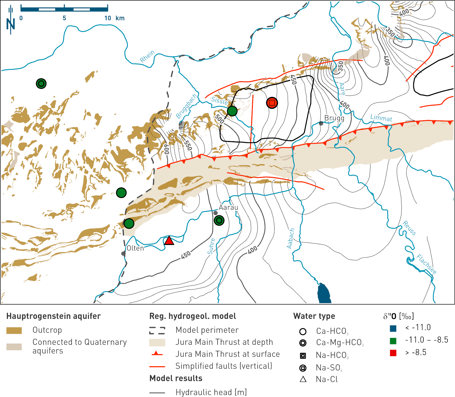
Fig. 4‑108:Map showing the spatial distribution of δ18O values in groundwaters collected from the Hauptrogenstein aquifer and the overlying Birmenstorf Member in Northern Switzerland
The symbols represent the water types while the colour of the fillings indicate the δ18O value range of the samples (see legend). The data range of δ18O of -11.0 to -8.5 ‰ VSMOW is representative for recent groundwaters of the region. Green colour denotes groundwater formed during climatic conditions similar as today in the study area. The map also shows the Hauptrogenstein outcrops, a simplified regional fault pattern, and the hydraulic head isolines according to the regional hydrogeological model (Section 4.5.4.3).
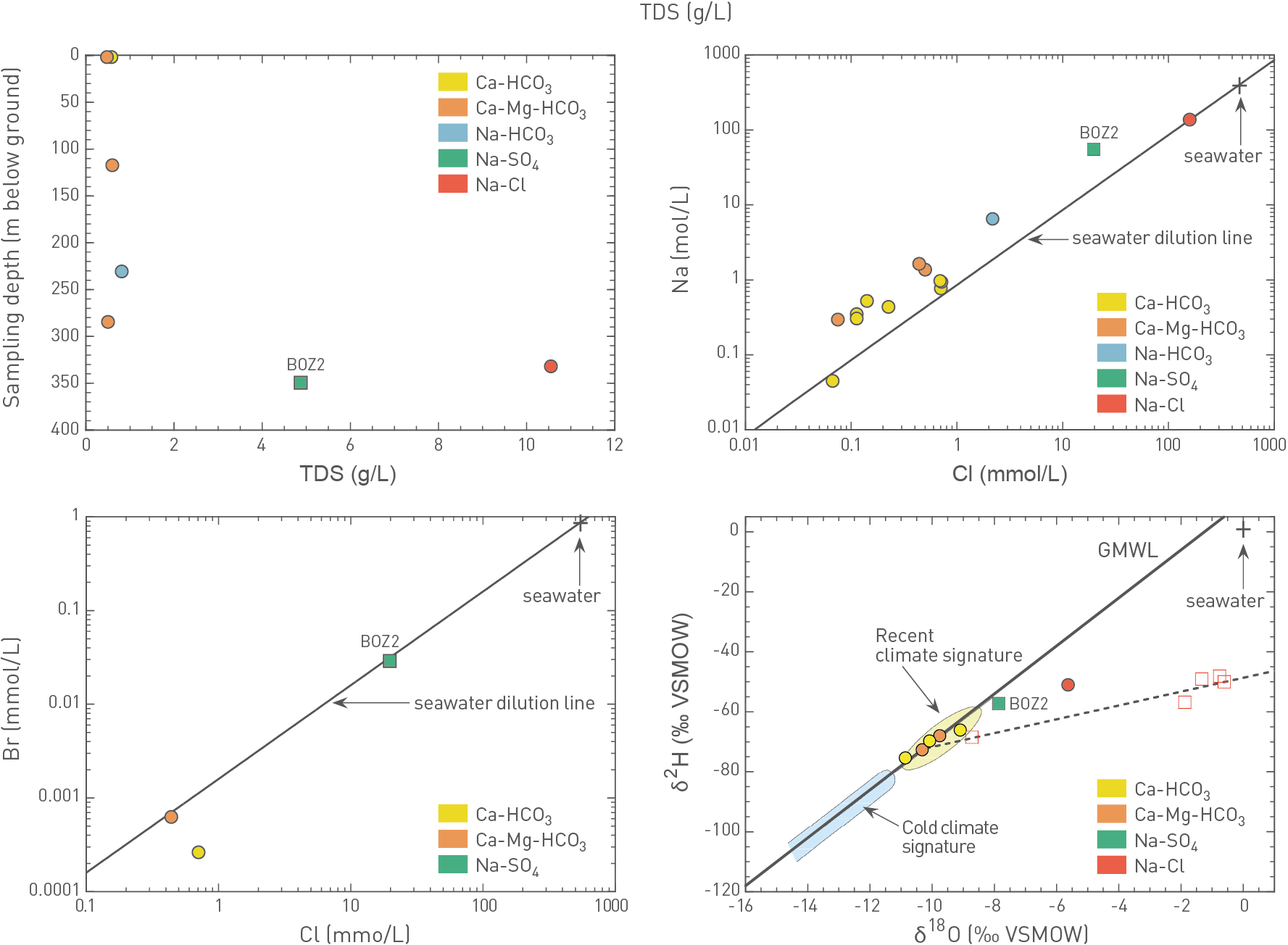
Fig. 4‑109:Cross-plots illustrating the behaviour of key hydrogeochemical parameters in groundwaters collected from the Hauptrogenstein aquifer in Northern Switzerland
Circle and square symbols represent samples reported in Waber & Traber (2022) and collected during the TBO campaign, respectively. Sampling locations are provided for the samples collected in the three siting regions. For stable isotopes (δ18O, δ2H), Na-Cl type groundwaters collected from the Malm aquifer in the ZNO and NL siting regions, and the corresponding linear correlation are plotted as well (open symbols) to illustrate that deep Na-Cl and Na-SO4 type groundwaters from the Hauptrogenstein aquifer may follow a similar trend. Samples from the overlying Birmenstorf Member are plotted as well.