
The difference in hydraulic heads between aquifers below and above the Opalinus Clay was regionally evaluated based on the result of the hydrogeological model (Fig. 4‑103; Nagra 2024n). This gives valuable information on transport dynamics under steady-state hydraulic conditions in the host rock and the confining units. In combination with the distance between the considered aquifers and the vertical distribution of hydraulic conductivities in the aquitards, it helps to constrain the magnitude and direction of the steady-state vertical hydraulic gradient in the host rock and confining units.
The Hauptrogenstein and Malm aquifers are the nearest aquifers above the Opalinus Clay approximately west and east of the Aare Valley, respectively. The presence or absence of the Keuper aquifer below the Opalinus Clay can potentially shorten or increase the distance that separates the over- and underlying aquifers. The hydraulic difference is thus evaluated considering the possible combinations (i.e. Malm – Keuper, Malm – Muschelkalk, Hauptrogenstein – Keuper and Hauptrogenstein – Muschelkalk) as illustrated in Fig. 4‑103.
The absolute magnitude of the hydraulic head difference is mainly below ca. 100 m (Fig. 4‑103) in the area of the siting regions but can be higher close to the main recharge boundaries of the aquifers. From a site-specific perspective, downward gradients are calculated in the JO siting region. Upward hydraulic gradients are, however, inferred in the northeastern part of the siting region in the case where the Hauptrogenstein and the Keuper aquifers are considered.
In the ZNO siting region, head differences involving the Malm aquifer and the Keuper or Muschelkalk aquifers indicate upward gradients. This agrees with the artesian conditions observed for the Keuper aquifer in the BEN borehole and low hydraulic heads in the Malm. The head difference tends to increase towards the northwest, reaching a value greater than 50 m.
In the NL siting region, hydraulic head differences are comparably small. While the combination Malm and Muschelkalk shows overall downward gradients, the northern part of the siting region indicates weak upward gradients when the Keuper aquifer is considered.
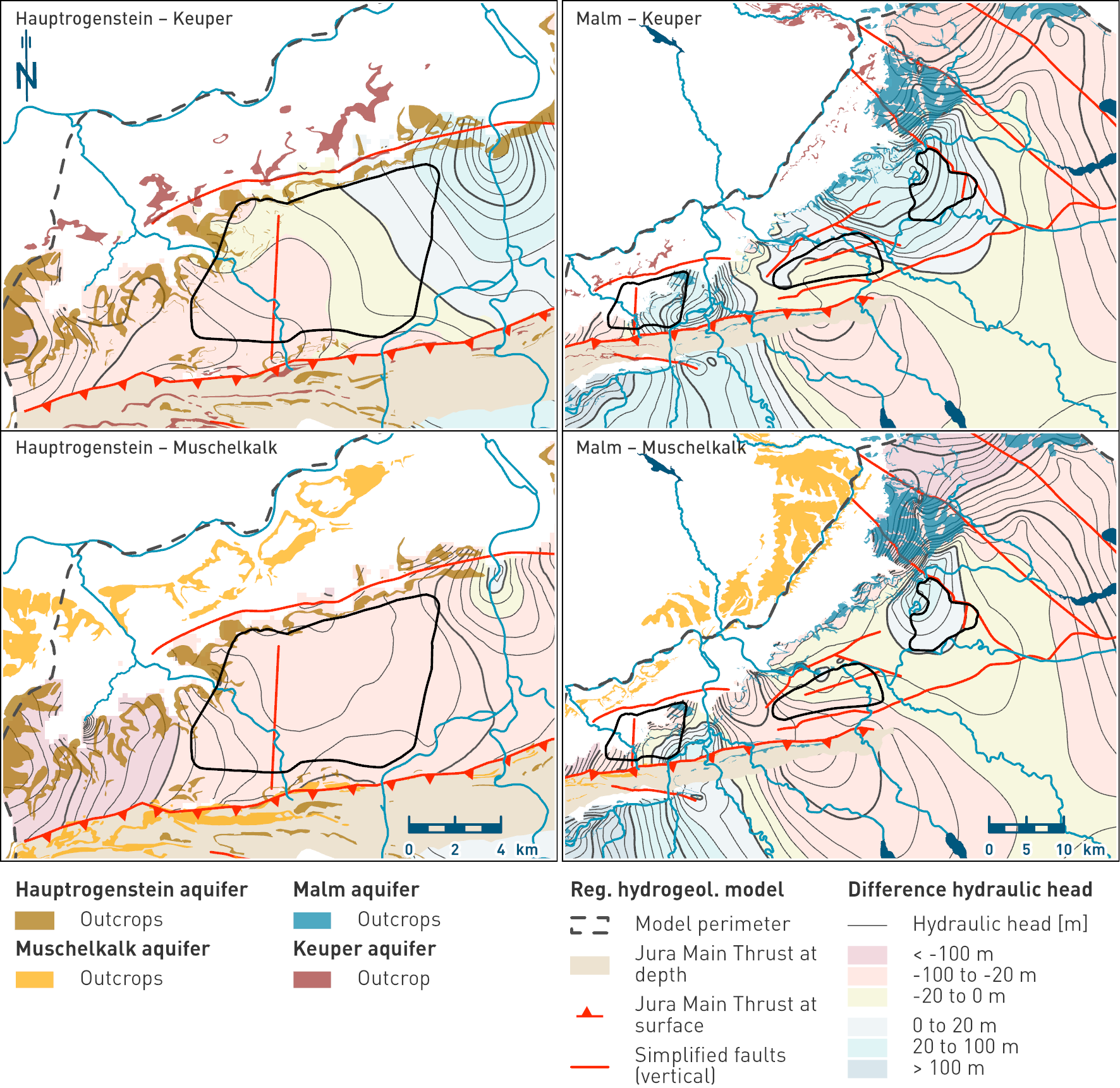
Fig. 4‑103:Difference in hydraulic heads between aquifers above and below the Opalinus Clay
Negative and positive values indicate upward and downward gradients, respectively. The maps show the outcrops and the simplified regional fault pattern used in the model.