
The Muschelkalk aquifer was implemented based on the hydraulic conductivities observed in the boreholes and a depth-dependence (Fig. 4‑96). In addition, tectonic overprint was taken into account (Nagra 2024n).
As for the Malm aquifer, the groundwater flow system in the zone north of the Jura Main Thrust and the Baden – Irchel – Herdern Lineament is controlled by the topography and the outcrop situation. The flow system in this zone is well supported with borehole data, notably within the siting regions. The area further to the south is less constrained by borehole data, but the sensitivity analyses show that the detailed situation in the southern part of the model is of little importance for conditions in the siting regions (Nagra 2024n).
In the northeastern part of the domain, the recharge of the Muschelkalk aquifer mainly occurs in the Wutach Valley where the Muschelkalk aquifer is outcropping at the valley flanks. The important groundwater inflow from the north leads to a regional groundwater divide roughly oriented northwest-southeast, the impact of which in the model is visible down to the southern model area. Such a divide has already been identified in earlier work (e.g. Nagra 2002). West of the groundwater divide, the flow system is aligned towards the discharge area near the confluence of the Aare and Rhine Rivers. Muschelkalk groundwater south of the Jura Main Thrust discharges in the lower Reuss and Aare Valleys, as well as in the Limmat Valley in the Baden area (i.e. discharge of thermal water), where the associated rivers cut through the Jura Main Thrust (Fig. 4‑102). This is in agreement with earlier work (Gmünder et al. 2014, Nagra 2014e).
Forward and backward particle tracking indicates that the groundwater flow in the NL and ZNO siting regions shares a similar pathway (Fig. 4‑102). It infiltrates in the northern Wutach Valley area, turns towards the southwest, flowing through the siting regions before exfiltrating after several tens of kilometres at the convergence of the Rhine and Aare Rivers.
The flow system in the JO siting region is controlled by the local tectonic situation, topography and the nearby discharge areas (Fig. 4‑102). Particle tracking indicates that the Muschelkalk aquifer is recharging at outcrops to the north of the siting region and by vertical recharge of water along the Jura Main Thrust to the south. Groundwater is discharging in the lower Aare Valley to the east, and the lower Sissle Valley to the west where outcrops meet Quaternary aquifers.
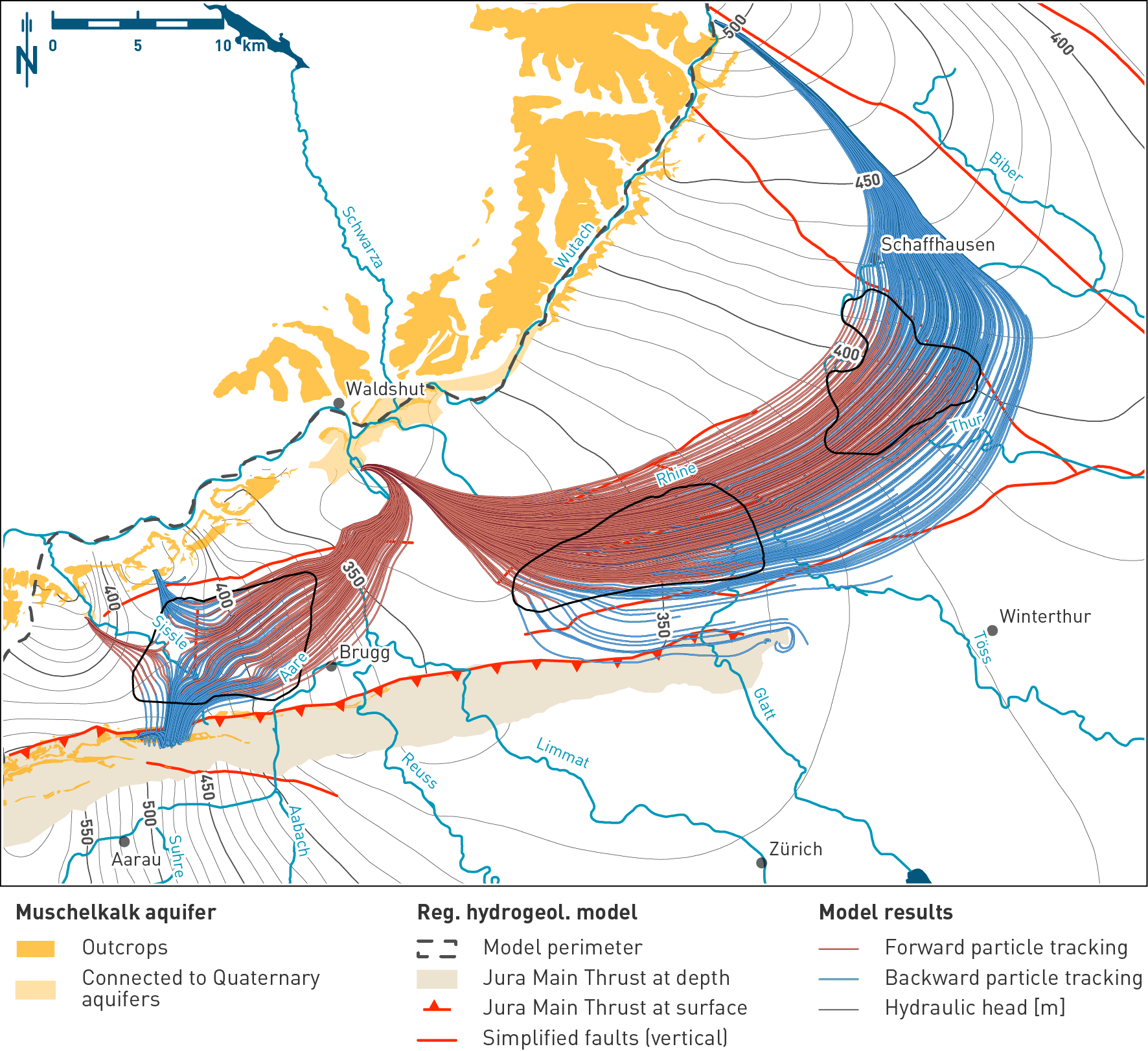
Fig. 4‑102:Simulated hydraulic heads and particle tracking identifying recharge and discharge areas in the Muschelkalk aquifer
Hydraulic head situation at the top of the upper Muschelkalk aquifer of the hydrogeological model. The map shows the outcrops and the simplified regional fault pattern used in the model. The displayed particle paths are a 2D projection of the 3D particle traces. Note the well-defined regional flow paths of the groundwater flowing through the NL and ZNO siting regions, and the more local groundwater flow system around the JO siting region.