
Where present, the Keuper aquifer is the nearest aquifer below the Opalinus Clay. It is characterised by important lithological variations (Section 4.2.4) and a large variability of its hydraulic properties (Section 4.5.3.10, Fig. 4‑95). In the regional groundwater flow model, the Keuper aquifer unit is abstracted in one layer. The local complexity of the associated groundwater flow systems was regionally evaluated through the following cases (Nagra 2024n):
-
Base case: It includes an almost site-specific parametrisation of the Keuper aquifer. The area north of the Jura Main Thrust and the Baden – Irchel – Herdern Lineament is subdivided into different zones based on hydrogeological observations, facies maps, and tectonic overprint (Nagra 2024n). The zone surrounding the ZNO siting region is linked to the occurrence of the brecciated, cavernous lithofacies of the Seebi Member (Section 4.5.3.10). Another zone approximates the extent of the comparably thick transmissive facies of the Gansingen Member as observed in the JO siting region (Section 4.5.3.10). Around the NL siting region, another zonation aims to represent an area of the Keuper aquifer dominated by fluviatile channels of the Ergolz Member.
-
Homogeneous isotropic case: To evaluate the impact of a less compartmentalised model on the groundwater flow system (i.e. in comparison to the base case), a homogeneous and isotropic medium was considered as an alternative to the base case (Fig. 4‑101).
The two cases were calibrated leading to a comparable fit between simulated and observed hydraulic heads. However, the base case results in a slightly better agreement between modelled and observed hydraulic heads for the siting regions (Nagra 2024n).
While the two cases show a distinct hydraulic head distribution (Nagra 2024n), both provide a consistent image of the main hydrogeological features of the Keuper aquifer:
-
Two different regional flow domains are recognised on Fig. 4‑101. A first groundwater flow system exists north of the Jura Main Thrust and the Baden – Irchel – Herdern Lineament. It is well constrained by the outcrops to the southeast of the Wutach River, but also in the lower Aare Valley and in the Tabular Jura north of JO (Fig. 4‑101). A second regional flow domain exists south of the Jura Main Thrust and the Baden – Irchel – Herdern Lineament.
-
The potential recharge areas are located between the Wutach and the Klettgau Valleys north of the NL and ZNO siting regions, and locally on Keuper outcrops north of the JO siting region (Fig. 4‑101). Similar to the Muschelkalk aquifer, the Keuper aquifer discharges in the lower Aare Valley as well as in the Quaternary aquifer of the Sissle Valley west of the JO siting region.
-
Calibration of the base case and the alternative homogeneous isotropic case led to low hydraulic conductivities in the area north of the Jura Main Thrust and the Baden – Irchel – Herdern Lineament. Values are between 10-8 and 10-10 m/s for the base case and approximately 10-9 m/s for the alternative case (Nagra 2024n). Particularly low values are found in the NL siting region for the base case (approximately 10-10 m/s), in agreement with the results of the hydraulic packer tests (Fig. 4‑94).
-
The two calibrated models (Fig. 4‑101) show similar groundwater flow patterns in the siting regions despite their difference in the distribution of hydraulic conductivities. Backward particle tracking indicates groundwater flow in the ZNO siting region towards the south-southeast impacted by the presence of the recharge area in the north. This agrees with the flow direction inferred from the hydraulic head data.
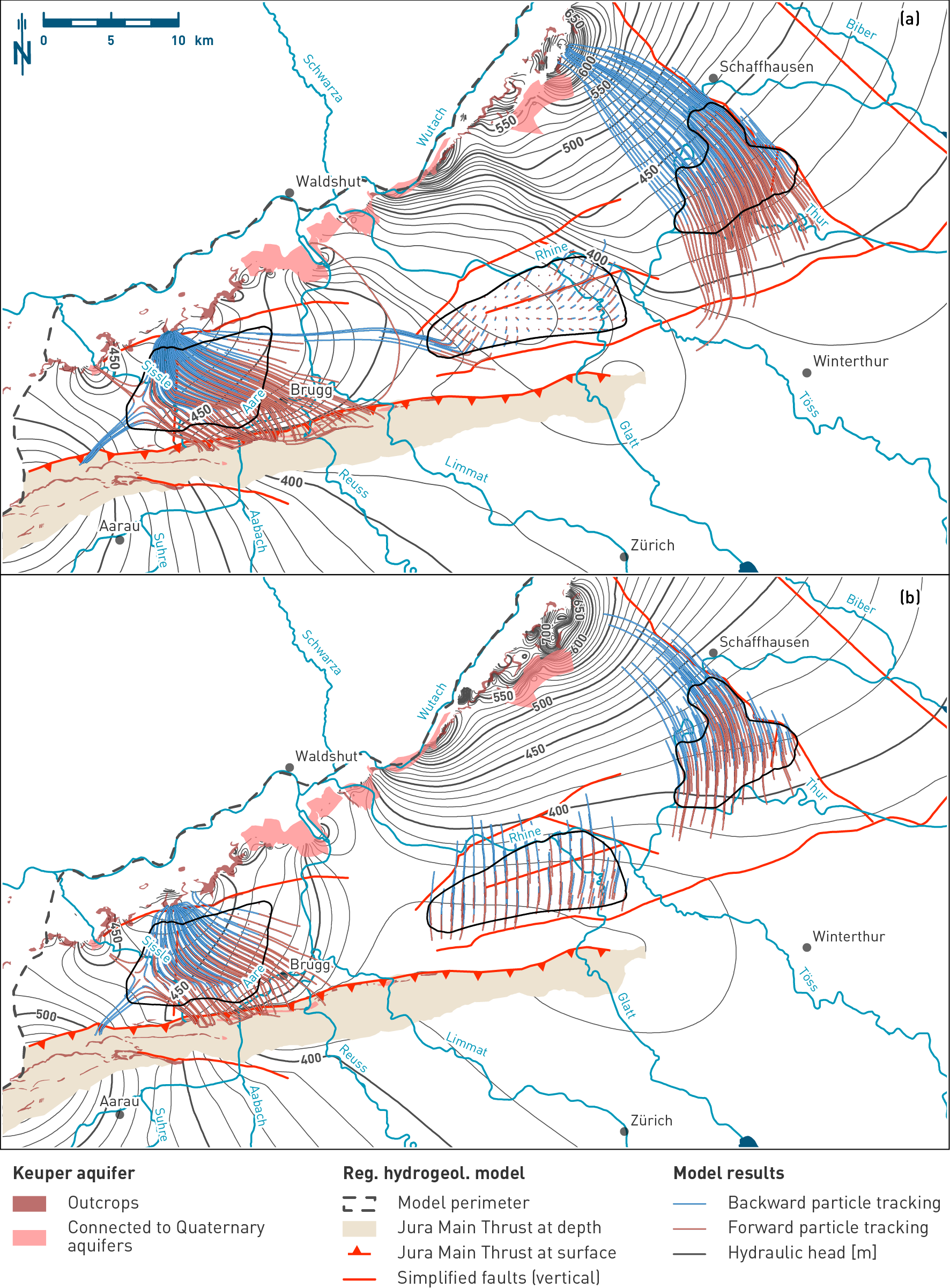
Fig. 4‑101:Simulated hydraulic heads and particle tracking in the Keuper aquifer identifying recharge and discharge areas for the base case (upper figure) and alternative homogeneous isotropic case (lower figure)
Hydraulic head situation at the top of the Keuper aquifer horizon of the hydrogeological model. Base case with different domains of hydraulic properties, alternative homogeneous isotropic case assuming uniform properties north of the Jura Main Thrust and the Baden – Irchel – Herdern Lineament. See text for detailed discussion. The map also shows the outcrops and the simplified regional fault pattern used in the model. The displayed particle paths are a 2D projection of the 3D particle traces. Note the short distances travelled by the particles released in the NL siting region during the considered time frame for the particle tracking indicating very slow flow velocities, particularly in the base case (see discussion in Nagra 2024n).
For the NL siting region, the two model cases indicate only small flow distances during the time frame considered for the particle tracking, highlighting the low hydraulic gradients and the comparably lower hydraulic conductivity in the base case. The major recharge areas are located in the north or northeast in both cases. From the siting region, the particles migrate towards the regional discharge area in the lower Aare Valley or towards the low hydraulic head zone in the Limmat north of the Jura Main Thrust.
Both models also show consistent results in the vicinity of the JO siting region: The hydraulic head distribution is mainly constrained by the presence of the Keuper outcrops to the north, where water is recharging, and the regional and local discharge areas in the lower Aare Valley and in the Sissle Valley respectively.