
The Malm aquifer is the nearest aquifer above the Opalinus Clay in the NL and ZNO siting regions. The model was implemented based on the hydraulic conductivities observed in the boreholes and a depth dependence. In addition, tectonic overprint was taken into account (Nagra 2024n).
The piezometric map (Fig. 4‑98) shows that the zone north of the Jura Main Thrust and the Baden – Irchel – Herdern Lineament is mainly affected by the local topography and the outcrop situation. The flow system in this zone is well supported with borehole data, notably within the siting regions. The area further to the south is less constrained by borehole data, but the sensitivity analyses show that the detailed situation in the southern part of the model is of little importance for conditions in the siting regions (Nagra 2024n).
The regional situation of the Malm aquifer is characterised by a piezometric dome in the northeasternmost corner of the model perimeter (Fig. 4‑98). The groundwater then flows towards the southeast driven by a steep hydraulic gradient. High hydraulic heads also exist in the Bodensee area, reflecting groundwater inflow from the east. Recharge also occurs locally along the Internal Jura where the Malm is outcropping.
The main discharge areas are located along the Rhine River where the Malm aquifer is in contact with the river and/or associated Quaternary aquifers (e.g. Rhine Falls and Rheinau area northwest of the ZNO siting region, the area of Kaiserstuhl – Hohentengen in the Rhine Valley north of the NL siting region, and at the confluence of the Aare, Reuss and Limmat Rivers near the town of Brugg). South of the Jura Main Thrust, Malm groundwater discharges in the Reuss and Aare Valleys where the associated rivers cut the Internal Jura (Fig. 4‑98).
The topography and outcrop position of the Malm aquifer in the northern part of the model leads to site-specific hydrogeological situations. Backward particle tracking from the ZNO siting region shows that the recharge of the Malm aquifer mainly takes place along Malm outcrops in the north. The model results indicate that the Randen fault acts as a drain, channelling the groundwater further to the southeast. Recharge also occurs locally along the Malm outcrops of the Südranden area. These groundwater flow systems then discharge in the Rhine Falls and Rheinau areas.
In the NL siting region, the recharge of the Malm aquifer mainly takes place through the thick Molasse units north of the Jura Main Thrust (i.e. northern part of the Lägern Anticline; Fig. 4‑98). This is indicated by the hydraulic head differences at the interface between the Malm aquifer and the USM (Fig. 4‑99). Note that the differences are more pronounced in the western part of the siting region than in the eastern part due to the topographical effect. The Jura Main Thrust and the Baden – Irchel – Herdern Lineament do not act as preferential pathways.
The groundwater discharge zone is located near Kaiserstuhl – Hohentengen north of the siting region where the Malm is in contact with the Rhine River (Fig. 4‑98).
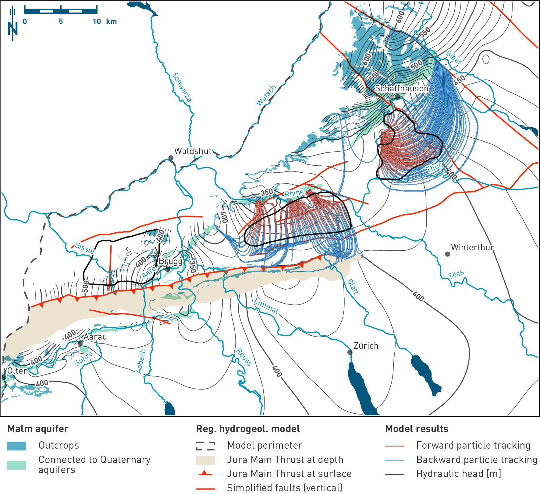
Fig. 4‑98:Simulated hydraulic heads and the particle paths identifying recharge and discharge areas in the Malm aquifer
Hydraulic head situation at the top of the Villigen Formation horizon of the hydrogeological model. The map also shows the outcrops and the simplified regional fault pattern used in the model. The displayed particle paths are a 2D projection of the 3D particle traces. Note the site-specific groundwater flow systems.

Fig. 4‑99:Head difference map between the Malm aquifer and the Lower Freshwater Molasse Group (USM)
Positive and negative head differences indicate upward and downward hydraulic gradients respectively. Hydraulic head difference were calculated using the results of the base case (Nagra 2024n). The top of the Villigen Formation and the top of the lowermost USM horizons of the model were considered. The map also shows the outcrops and the simplified regional fault pattern used in the model. Note the negative hydraulic head difference in the NL siting region indicating vertical recharge of the Malm aquifer through the Molasse deposits.