
The Muschelkalk aquifer consists of the carbonate rocks of the Schinznach Formation. As a result of the large-scale uniform lithology (Fig. 4‑7), it is a regional aquifer in Northern Switzerland (e.g. Nagra 2014e, Dossier V) and Southern Germany (e.g. Stober & Villinger 1997, Ufrecht 2018) with a typical thickness around 70 to 80 m in the siting regions. The aquifer is bounded at the top by the Bänkerjoch Formation and at the bottom by the Zeglingen Formation (Fig. 4‑8, Section 4.2.2). Note that the uppermost dolomite of the Zeglingen Formation can be part of the aquifer (former 'Dolomit der Anhydritgruppe').
In the boreholes in Northern Switzerland, the unit mainly consists of dolomite and calcite in varying proportions. In addition, sulphate minerals (anhydrite, celestite) are locally observed.
As a result of the comparably high hydraulic conductivities, the Muschelkalk aquifer is exploited in many wells, including for the spas of Baden and Bad Schinznach (e.g. Burger 2011, Waber & Traber 2022 and further references therein).
Water flow in the deep Muschelkalk aquifer is mainly related to fractures in combination with a partly porous and permeable rock matrix (Fig. 4‑9). Of the four different members of the Schinznach Formation (Section 4.2.2), the dolomitic Stamberg Member is most relevant for water conductivity via the rock matrix. This is mainly because of 1) the early diagenetic dolomitisation (classical ‘Trigonodus-Dolomit'; Adams et al. 2019, Aschwanden et al. 2019a) and 2) the presence of macropores formed by local dissolution of anhydrite nodules by upwelling of groundwater from the Buntsandstein and/or the crystalline basement during the different geodynamic situations in the Oligocene and the Miocene (Aschwanden et al. 2019b; see also Section 4.5.5.5). At present, the porosity of the Stamberg Member in the TBO boreholes can locally exceed 20 vol.-% based on geophysical logging (Fig. 5‑10). Fractures increase the hydraulic conductivity by 1 – 3.5 orders of magnitude compared to the rock matrix (Aschwanden et al. 2017). Depending on where brittle deformation has occurred, the most transmissive intervals can also be located in the Liedertswil Member or the Leutschenberg and Kienberg Members where limestones dominate (see Section 4.2.2). With increasing overburden, mechanical and chemical compaction cause a substantial decrease in the hydraulic conductivity (Fig. 4‑96).
Epigenic karst is observed in shallow situations, where the overlying units were eroded or where the cover is only thin or patchy (e.g. Hoehn 1979, Plum et al. 2008). Hypogenic karstification under thick overburden has only been observed where carbon dioxide of magmatic or volcanic origin is upwelling along fractures extending to a greater depth, leading to carbonate dissolution; such conditions have only been reported north of the investigation area in Baden-Württemberg (Plum et al. 2008, Ufrecht 2006). In the siting regions in Northern Switzerland, no expressions of, or drivers for, such hypogenic karst development have been observed. The interpretation of 3D seismic data provides indications for dissolution processes in the Bänkerjoch and / or the Schinznach Formation probably related to subaerial exposure (Nagra 2024a, 2024b, 2024c).
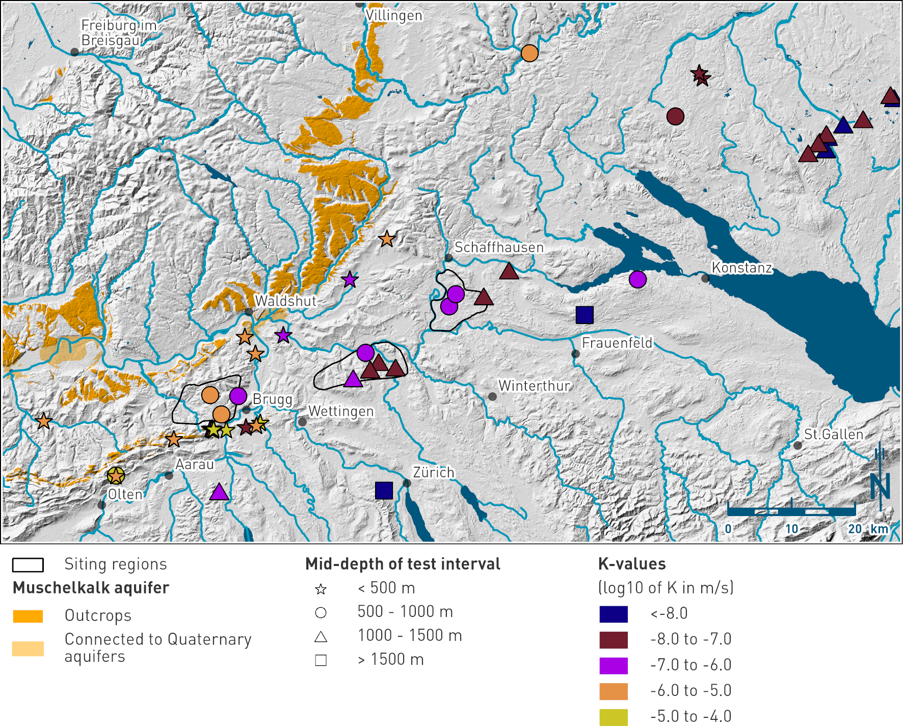
Fig. 4‑96:Hydraulic conductivities from in-situ hydraulic tests in the Muschelkalk aquifer in Northern Switzerland and Southern Germany
The length of the test intervals varies between approximately 10 and > 100 m. The figure shows the regional distribution of hydraulic conductivity and its dependence on depth (see text for further details).
The test transmissivities show a comparably uniform distribution of the values, i.e. no large regional differences are evident (Fig. 4‑86). The overburden thickness seems to exert a major control on the properties (Fig. 4‑96).
In the siting regions, the Muschelkalk aquifer was tested in all boreholes and the hydraulic conductivity was sufficiently high in all cases to sample groundwater. The location and lengths of the test intervals were chosen based on indications such as losses of drilling fluid and observations on drill cores (fractures, porous zones). From the resulting distribution of the packer test positions, no particular subunit with elevated hydraulic conductivity is evident (Fig. 4‑85). In comparison to the Malm aquifer, the conductive sections seem to be more distributed throughout the entire unit and are probably linked to subvertical fractures and joints. The hydraulic properties in the siting regions agree with the regional dataset, particularly if the depth-dependence is taken into account (Fig. 4‑96). The typical test transmissivity in the siting regions is around 10-5 m2/s and the values scatter within the narrow range of ± 1 order of magnitude. Despite the larger overburden resulting from the stratigraphic position, the transmissivity is approximately one order of magnitude larger than in the Malm aquifer (Fig. 4‑86). This enables a large-scale connected deep flow system (Section 4.5.5.5).