
The Malm aquifer relates to the thick limestone units above the Wildegg Formation, that is the «Felsenkalke» and «Massenkalk» and the Villigen Formation. The latter formations are separated by the marly Schwarzbach Formation (Fig. 4‑85, see also Section 4.2.9). The upper limit of this hydrogeological unit is defined by the Eocene Siderolithic Group and the Lower Freshwater Molasse Group (USM).
The hydrogeological definition of the vertical extent of the Malm aquifer unit comes mainly from outcrop observations in the Internal Jura, in Canton Schaffhausen and in the Swabian Alb area of Southern Germany. Here, the aquifer can have a high hydraulic conductivity and a large vertical extent because of the structural overprint and karstification. The extent of karstification depends on many aspects and is known to decrease with depth and with overburden of Molasse (e.g. Plum et al. 2008).
The situation below the thick Molasse cover, notably in the siting regions ZNO and NL, is different. Here, the units were affected by karstification during the Eocene (Chapter 3). Such palaeokarst features are typically filled with clay-mineral-rich sediments and can be observed several decametres into the limestones. This palaeokarst seems hydraulically not relevant today (e.g. BUL1 borehole hydrotest, Fig. 4‑87) but a locally incomplete filling of the palaeokarst by siderolithic clay cannot be excluded. The thick cover of Molasse units currently prevents further karstification. In this zone, water flow is essentially restricted to fractures.
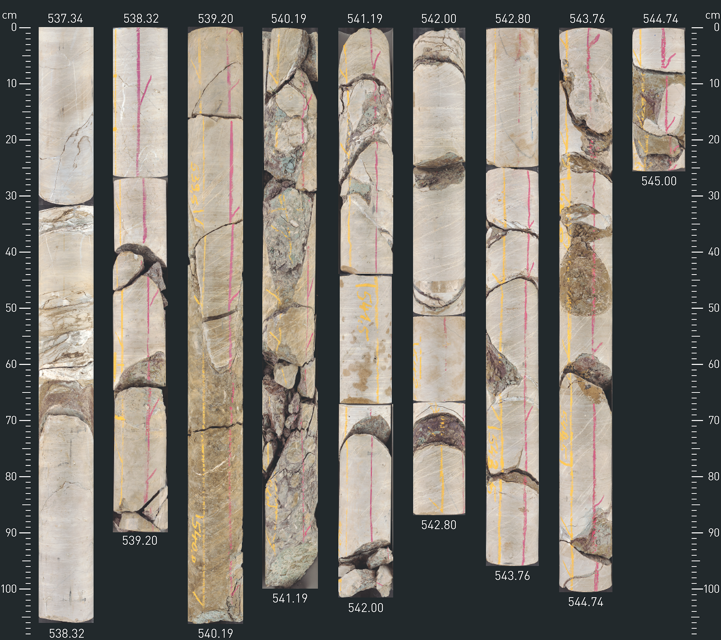
Fig. 4‑87:Drill core pictures from the hydraulic test interval in the «Felsenkalke» and «Massenkalk» of the BUL1 borehole
Hydraulic test BUL1-1-MAL1 (537.2 – 545.0 m) yields low T of 1 × 10-11 m2/s (K = 2 × 10-12 m/s). Test interval includes limestone with silty-clay-filled palaeokarst voids with a tectonic overprint (see also Nagra (ed.) 2021a, Dossier V).
Tectonic overprint and recent karstification close to the surface are probably the dominant features affecting the regional distribution of hydraulic conductivity (Fig. 4‑88). In addition, the Malm aquifer is partly composed of sponge algae reefs in which cavernous dedolomite is encountered (e.g. Plum et al. 2008, Stober et al. 2013). On the regional level, the differing relevance of these features results in a scatter of around six orders of magnitude in the hydraulic properties (Fig. 4‑86, Fig. 4‑88).
In the siting regions in Northern Switzerland, these rocks consist in many cases of almost pure calcite. The dolomite/ankerite component is typically below a few wt.-% and is more commonly detected in the Villigen Formation. Pyrite contents are low, with a trend to somewhat higher values in the marly sections (rarely exceeding 1 wt.-%).
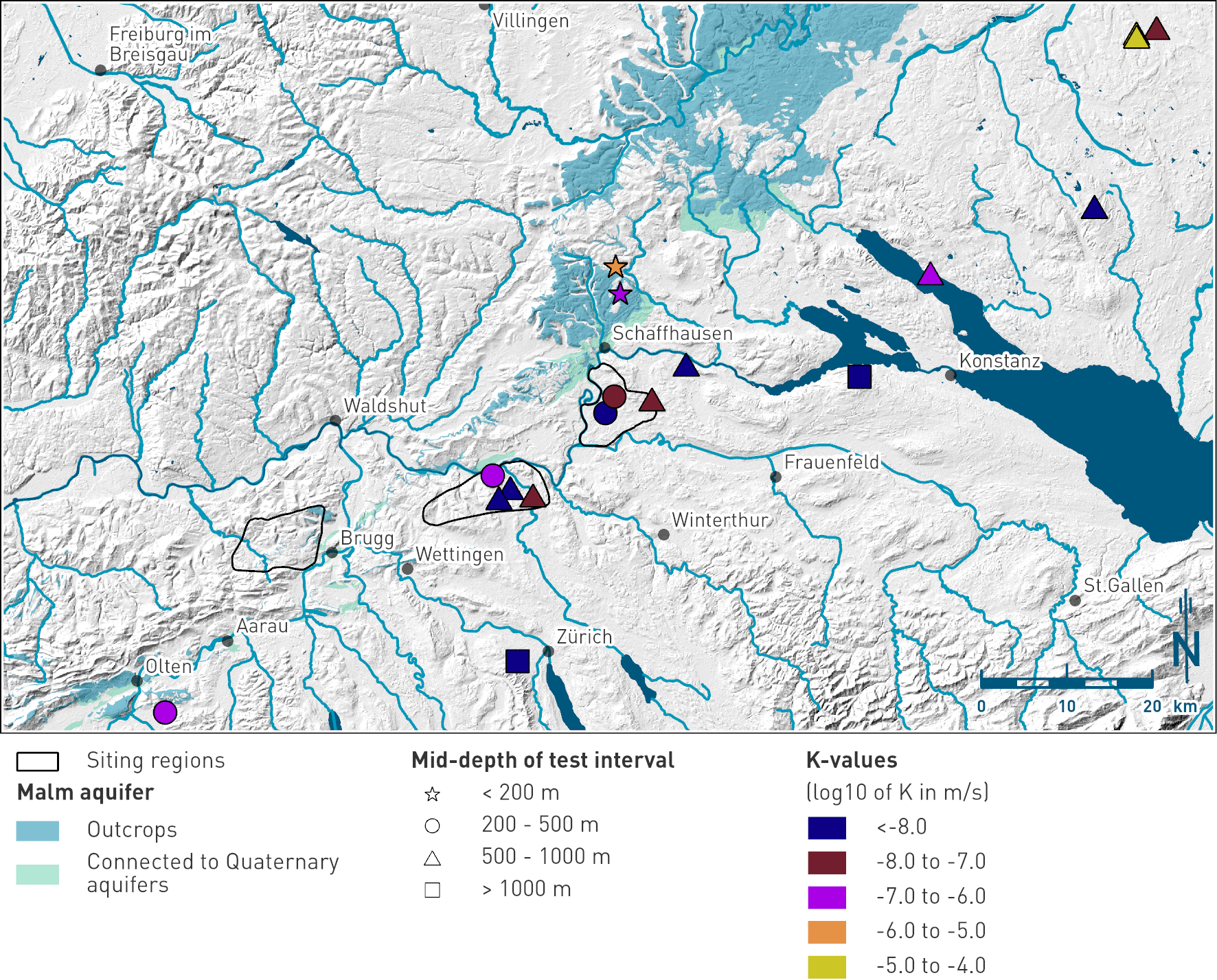
Fig. 4‑88:Hydraulic conductivities from in-situ hydraulic tests in the Malm aquifer in Northern Switzerland and Southern Germany
The length of the test intervals varies between < 10 and > 100 m. The displayed dataset includes results of hydraulic tests performed in closed intervals as well as in open boreholes.
In the majority of the TBO boreholes in NL and in ZNO, fluid logging was carried out over the major parts of the Malm aquifer. These allow the transmissive sections to be localised and quantified as well as a comparison with the structural inventory from the drill cores and from the image logs. The investigations show highly localised groundwater flow related to fractures. The results of the fluid logging also served to position the packers for the hydraulic tests (that included the aim of sampling groundwater). The majority of the most transmissive sections were identified in the «Felsenkalke» and «Massenkalk», that is above the marly Schwarzbach Formation (Fig. 4‑85). This suggests that the water flow may be related to solution-enhanced fracture networks that developed above the Schwarzbach Formation, most likely at the time of palaeokarst formation. However, the hydraulic packer tests in the NL and ZNO siting regions indicate, compared to the regional dataset and to the Muschelkalk aquifer (Section 4.5.3.12), relatively low hydraulic conductivities with typical values around 10-8 m/s. This is consistent with the much higher residence times of the Malm groundwaters in comparison to the Muschelkalk groundwater (Section 4.5.5). In contrast to the fractured zones, the matrix is characterised by low porosity (Fig. 5‑10) and low hydraulic conductivity.
The Malm aquifer exists in part of the JO siting region at shallow level. It is not discussed in this report because the focus in JO is on the Hauptrogenstein aquifer which is closer to the host rock.