
-
This section subdivides and describes the sedimentary stack based mainly on hydrogeological criteria. Primarily, it differentiates between aquifers, where hydraulic conductivity is typically sufficiently large to allow for groundwater sampling, and aquitards. In addition to the hydraulic properties, this section gives indications on the nature of water flow.
-
As a result of the earlier investigation programmes by Nagra in Northern Switzerland, the regional hydrostratigraphy was already well established and has now been updated with the new data (Fig. 4‑84). The units are divided into regional and local aquifers separated by aquitards.
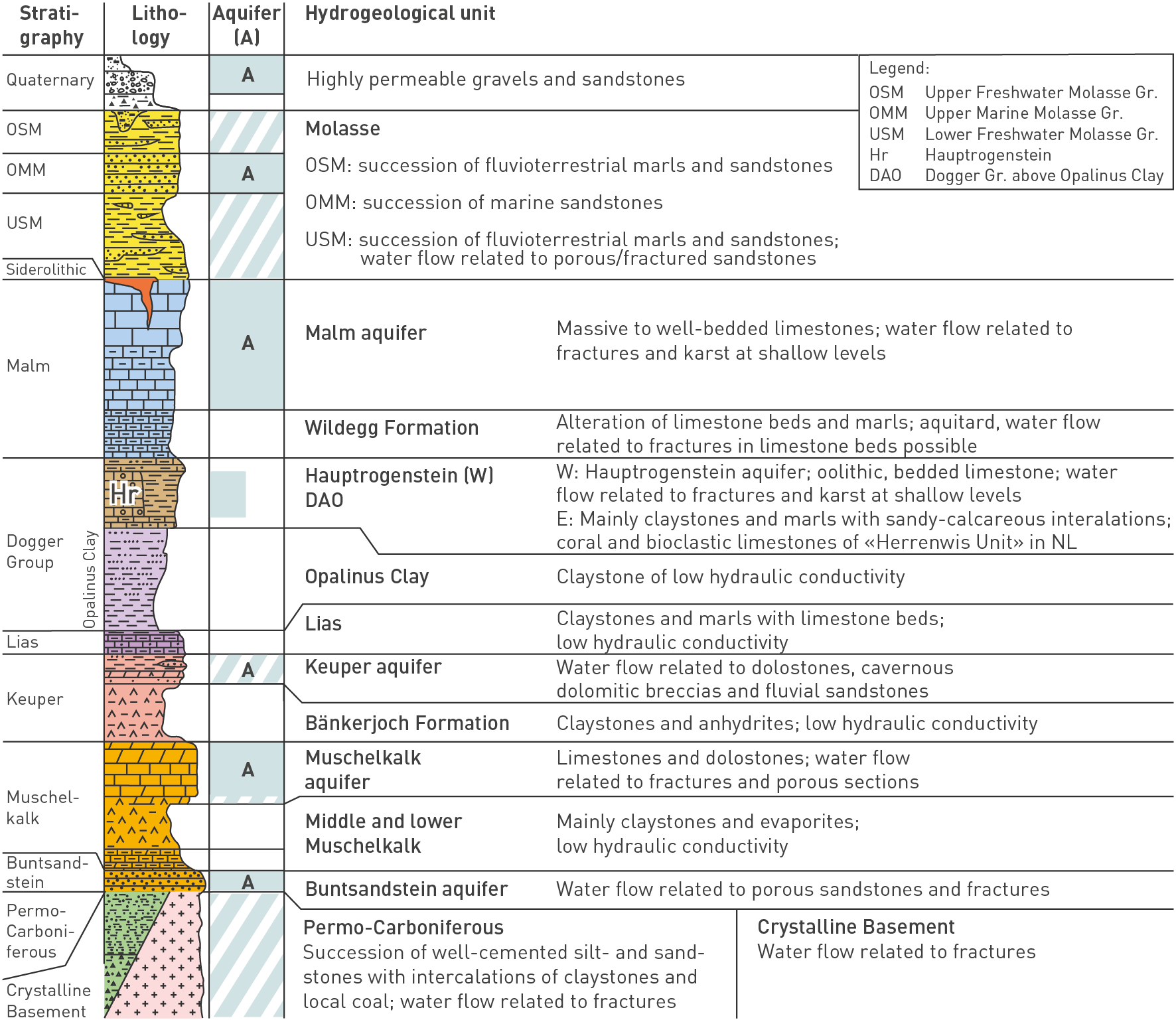
Fig. 4‑84:Hydrostratigraphic units of Northern Switzerland
The figure focuses on the situation relevant in siting regions. For the Dogger Group, it illustrates the facies change from the carbonate-rich Hauptrogenstein in the west to more clay-mineral-rich units further eastwards (Section 4.2.7). Hatched areas indicate local aquifers or units in which the water flow is linked to a specific lithology (e.g. sandstones in the USM). Gr.: Group.
Groundwater flow occurs either in the porous matrix or along discontinuities such as fractures or karst features. The links to lithofacies (Section 4.2) and to the structural overprint (Section 4.3) are important in understanding fluid flow. The clay-mineral content is used as a proxy for the mechanical competence and thus deformation behaviour of the rock (i.e. the more clay minerals the less prone to brittle deformation; see also Sections 4.9, 5.5 and 5.6).
The regional aquifers refer to the thick and brittle carbonate rocks, namely the Malm aquifer, Hauptrogenstein aquifer (JO and the area to the west) and Muschelkalk aquifer. These aquifers are termed regional because of their comparably uniform lithology in Northern Switzerland. The units between these regional aquifers are mostly aquitards rich in clay minerals (Fig. 4‑84), except for the local Keuper aquifer and the «Herrenwis Unit» which are discussed later in more detail.
Specifically, the following characterisation focuses on the section between the Opalinus Clay and the regional aquifers above and below. These aquifers, together with the occurrence of the local Keuper aquifer, define the maximum thickness of the low-permeability units and provide the hydrogeochemical and hydraulic boundary conditions to the aquitards in between.
Additional aquifers occur in shallower units (e.g. Upper Marine Molasse Group (OMM), sandstone channels in the Lower Freshwater Molasse Group (USM)) and in deeper units (e.g. Buntsandstein Group, crystalline basement; Fig. 4‑84). These were detailed in many earlier reports and publications (e.g. Thury et al. 1994, Klemenz et al. 2000, Küpfer 2005, Gander 2004, Plum et al. 2008, Waber & Traber 2022).