
The relevant elements of the hydrogeological system comprise the topography, the river network, the sedimentary succession and the properties of each unit within it and the tectonic situation including the fault systems (Fig. 4‑83).
The regional aquifers of interest comprise the Malm aquifer, Hauptrogenstein aquifer (JO and the area to the west) and Muschelkalk aquifer and are described further in the hydrostratigraphy section below (Fig. 4‑84, Section 4.5.3). Potential recharge areas of the aquifers of interest are located in the hilly area to the north of the NL and ZNO siting regions (Fig. 4‑83), notably the large zones of Malm Group outcrop in Canton Schaffhausen and the Wutach Valley area for the Muschelkalk aquifer. For the JO region, the aquifers of interest outcrop along the Internal Jura (Folded Jura) in the south and in the External and Tabular Jura in the north. Additional outcrops of the regional aquifers occur in the Alps and may contribute to the recharge of the southern Molasse Basin (Nagra 2024n).
The potential discharge areas are located where the river valleys cut into the mostly SSE-dipping aquifer units. Regional scale discharge areas are located along the Rhine River and in the lowermost Aare Valley. Additional potential discharge areas exist in smaller valleys. The river valleys are typically filled with highly permeable unconsolidated sediments which host important groundwater resources used for water supply. These aquifers are often characterised by intensive interaction with the rivers.
The Jurassic rocks are covered by increasingly thick Molasse units towards the south-east because of the general dip of the strata. In the southern part of the basin, the Malm aquifer is covered by a several kilometre thickness of Molasse (Fig. 3‑2).
Regional fault systems delimit the geological siting regions, affect the outcrop situation and the continuity of units of interest. The Jura Main Thrust is an important example (Fig. 3‑3, Fig. 4‑54 and Fig. 4‑83). Discharge areas are located where it is cut by the valleys of Limmat, Reuss and Aare. At these locations, the spas of Baden and Bad Schinznach use thermal water ascending in the Muschelkalk aquifer from deep parts of the (southern) Molasse Basin.
The lithological diversity of the sedimentary succession results in important variations in the hydraulic conductivities in the vertical direction. That is, there are different aquifer levels separated by aquitards. The importance of regional fault zones and potential cross-formation flow is evaluated with the hydrodynamic model (Nagra 2024n) and discussed based on hydrogeochemical arguments (Section 4.5.5).
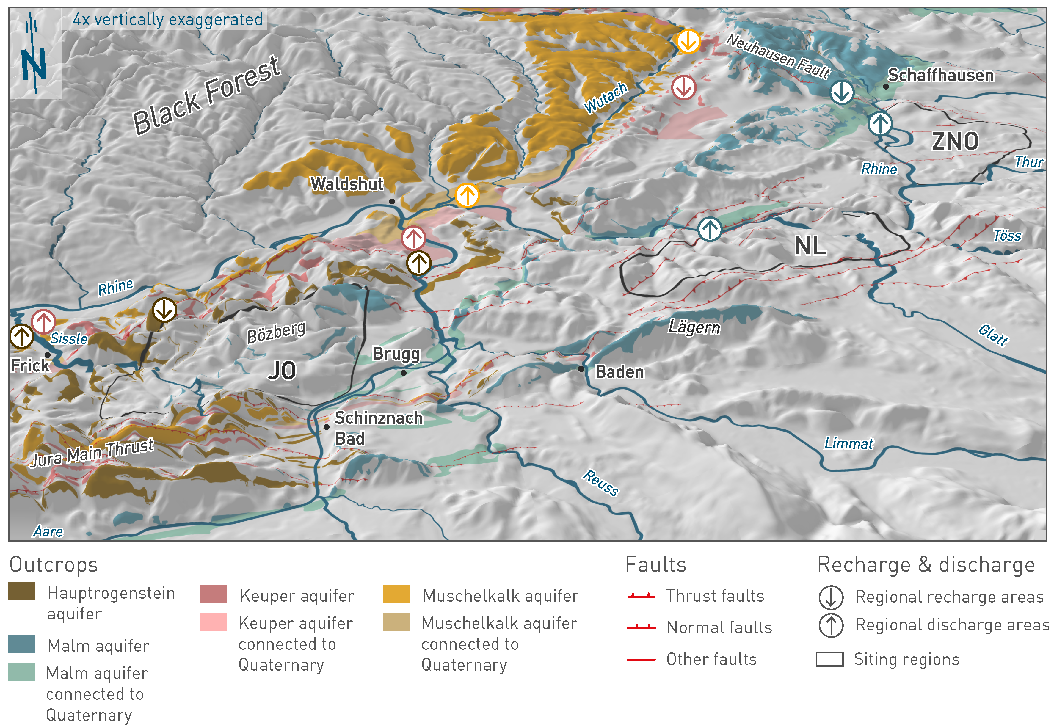
Fig. 4‑83:Aquifer outcrops, river network, regional fault zones and potential recharge and discharge areas relevant for the siting regions
The digital elevation model is vertical exaggerated by a factor 4. Regional recharge areas: Malm aquifer: Südranden and Randen areas; Hauptrogenstein aquifer: Frickberg and adjacent outcrops; Keuper aquifer: Hallauerberg and adjacent areas; Muschelkalk aquifer: Upper Wutach Valley. Regional discharge areas: Malm aquifer: Rheinfall area, Rhine Valley near Kaiserstuhl; Hauptrogenstein aquifer: Lower Aare Valley, Sissle Valley; Keuper aquifer: Lower Aare Valley, Sissle Valley; Muschelkalk aquifer: Confluence of Aare and Rhine River area, Sissle Valley.