
The Dogger Group above Opalinus Clay in the study area was deposited in a shallow epicontinental sea bordered by the Vindelician Land in the east, the Alemannic Land to the south, the Celtic Platform to the west and the London-Brabant Massif and Rhenish Massif to the north (Fig. 3‑9). The transgression of the sea onto the Alemannic Land, which began in the Late Toarcian, continued and the last small remnants or islands on the former southern edge (e.g. Windgällen) were also flooded in the course of the Aalenian and Bajocian (Trümpy 1959). Overall, the depositional environment is dominated by fine-grained siliciclastic input from these landmasses and/or from even farther source areas to the north, leading to relatively high sedimentation rates (Fig. 4‑4, Fig. 4‑5, Fig. 4‑6). Additionally, also shallow marine environments dominated by in-situ carbonate production were associated with high sedimentation rates (Hauptrogenstein, «Herrenwis Unit»). Periods with high sedimentation rates are interrupted by intervals with condensation with very low sedimentation rates or even no net deposition. In several intervals, the vertical facies associations are organised in nested facies trends or cycles, which start with argillaceous sedimentary rocks that become more silty and finally calcareous to iron-oolitic at the top. Some of these facies trends seem to reflect changes in relative sea level and/or climate variability, and their boundaries might be partly related to boreal or global sequence boundaries (Fig. 4‑35). However, these facies trends are often not complete. Their strata may strongly vary laterally in thickness and facies depending on basin bathymetry and bottom currents causing sediment mobilisation, transport, and accumulation. The depositional evolution of the Dogger Group above Opalinus Clay is subdivided here into four time intervals (Fig. 4‑33):
The first time interval (170.9_Aal_300 to 170.9_Aal_200) spans the Middle Aalenian (Murchisonae to lower part of Bradfordensis ammonite Zones; Fig. 4‑33, Fig. 4‑42). It includes, in JO, the interval from the Top Opalinus Clay to the top of the lower part of the Passwang Formation (Sissach Member to lower part of the Waldenburg Member, Fig. 4‑37). In NL and ZNO, it corresponds to the interval from the Top Opalinus Clay to the top of the lower part of the «Murchisonae-Oolith Formation» (Fig. 4‑33, Fig. 4‑38, Fig. 4‑39). This first time interval is characterised by strong condensation in JO, eastern NL (BUL1) and ZNO, which is reflected in the occurrence of calcareous and iron-oolitic hardgrounds. Only in the western part of NL was an interval several metres thick and comprised of marl, bioclastic limestone and iron-oolite deposited (BAC1). A similar succession exists ca. 10 km to the east of NL at the Surb River and Acheberg (Wohlwend et al. 2019), indicating a potential eastward extension of this facies. The interval in NL also includes cross-bedded limonitic limestone, suggesting transport by bottom currents. This interval could have accumulated in a local depression, or it could have accumulated by local carbonate production (e.g. crinoids) and transport by bottom currents forming a positive relief.
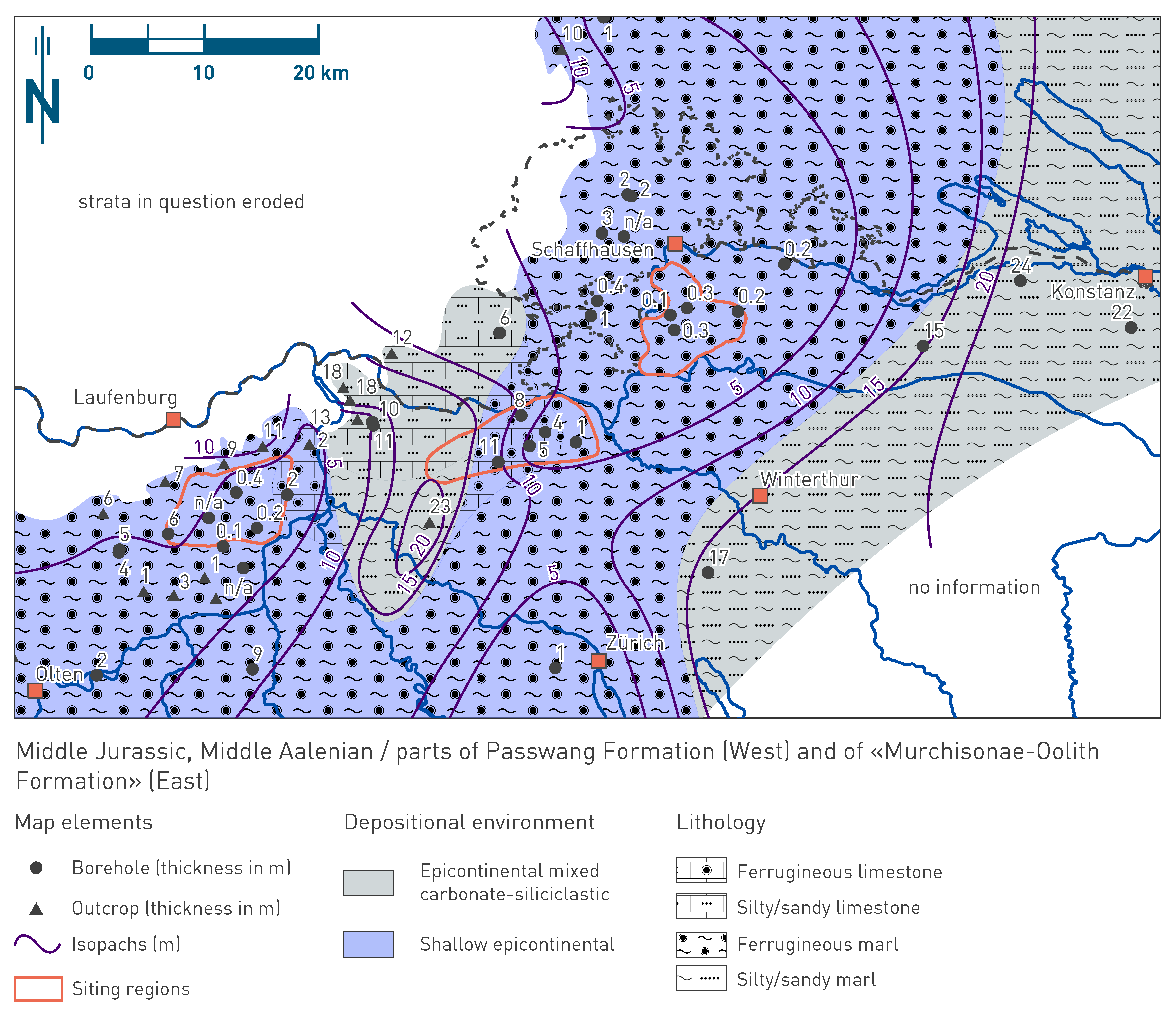
Fig. 4‑42:Map of depositional environments during Middle Aalenian
Refer to Fig. 4‑3 for a schematic representation of depositional environments. The north arrow refers to present-day geographic north. Map shows the setting during the "first time interval" (170.9_Aal_300 to 170.9_Aal_200) as discussed in the text.
The second time interval (170.9_Aal_200 to 168.2_Baj_300) spans the late Middle Aalenian to Early Bajocian (Bradfordensis to Laeviuscula Zones; Fig. 4‑33, Fig. 4‑43). In JO, it corresponds to most of the middle part of the Passwang Formation (i.e. most of the Waldenburg Member and lower part of the Brüggli Member), whereas in NL and ZNO, mostly to the Wedelsandstein Formation and the lower iron-oolitic part of the «Humphriesioolith Formation». Within this interval, an additional timeline (168.2_Baj_400) was identified at the top of calcareous beds that enables this interval to be separated into at least two facies trends or cycles. In the second time interval, the depositional environments in JO and ZNO show many similarities with a mainly silty and argillaceous sediment with many calcareous (mostly bioclastic but also micritic) to sandy beds. These beds or successions of beds can be partly correlated on a local scale, i.e. between boreholes within the siting regions (Fig. 4‑37, Fig. 4‑39). However, these beds do not represent regional marker beds such as some of the calcareous and iron-oolitic hardgrounds. The beds of the Wedelsandstein Formation might trace storm events or phases with elevated transport that brought sediments e.g. from carbonate platforms in the west into the area and formed sheet-like deposits. Locally, production of carbonates (crinoids) may also have occurred. Generally, these successions were formed during times of high sedimentation. In NL this interval is dominated by claystone to silty claystone and shows a clear thickness increase from west to east (Fig. 4‑38). For example, there are pronounced thickness increases for the uppermost facies trend (168.2_Baj_400 to 168.2_Baj_300) from ca. 6 m in STA2 to 19 m in STA3 over a distance of only 1.8 km. Assuming that this facies trend represents the same time interval, sedimentation rates must have increased significantly from west to east. In combination with seismic facies analysis (Fig. 4‑41), this sediment body is interpreted as an argillaceous drift deposit that formed a positive relief and basis for the following depositional processes that generated the «Herrenwis Unit».
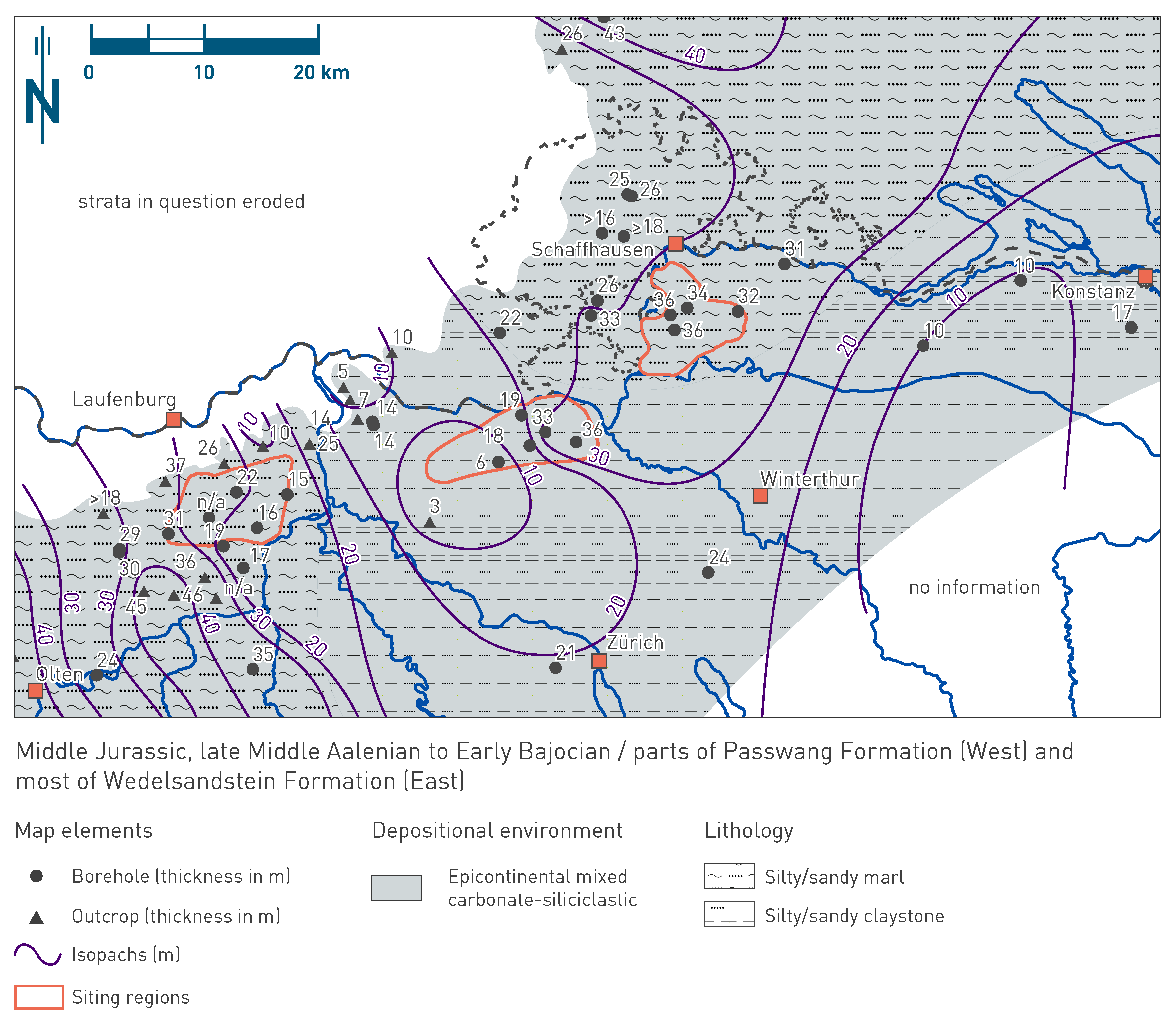
Fig. 4‑43:Map of depositional environments during late Middle Aalenian to Early Bajocian
Refer to Fig. 4‑3 for a schematic representation of depositional environments. The north arrow refers to present-day geographic north. Map shows the setting during the "second time interval" (170.9_Aal_200 to 168.2_Baj_300) as discussed in the text.
The third time interval (168.2_Baj_300 to 168.2_Baj_200) spans the Early Bajocian (Sauzei to Humphriesianum Zones; Fig. 4‑33, Fig. 4‑44). In JO it corresponds to an interval in the upper Passwang Formation (uppermost part of the Brüggli Member and the «Humphriesi-Schichten»), in western NL (BAC1) mostly to the «Humphriesioolith Formation», in eastern NL to the «Herrenwis Unit», and in ZNO to the middle and upper parts of the «Humphriesioolith Formation» (Fig. 4‑33). In JO the third time interval is mostly characterised by low sedimentation rates. Iron-oolitic sediments were partly produced in situ during phases of sediment starvation, perhaps in relatively elevated regions and transported and accumulated in depressions or as offshore bars. In eastern NL, the isolated carbonate platform of the «Herrenwis Unit» developed during this time interval (Fig. 4‑40, Fig. 4‑41). The carbonate platform, as found in STA3 and BUL1, mainly consists of in-situ grown coral bioherms (plate- and pillarstone sensu Insalaco 1998), but also some bioclastic limestone (rudstone; Ruchat et al. 2024). In STA2 the more basinward part of the carbonate platform, the periplatform wedge, was drilled with an intercalation of siliciclastic and calcareous sedimentary rocks that contain few transported coral fragments (Fig. 4‑38). The carbonate platform developed on top of the positive relief of the underlying argillaceous units, probably a sediment drift deposit (mostly Wedelsandstein Formation). On top of this positive relief, the conditions for coral growth were more favourable, probably because of better light conditions (shallower water depth) and oxygen availability (current circulation). The carbonate platform is interpreted to consist of several horizontally 100 m- to decametre-scale mounded coral bioherms or patch-reefs with flanking or intercalated bioclastic limestone as observed in time-equivalent reefs in Lorraine and Burgundy (Geister & Lathuilière 1991, Brigaud et al. 2024; Fig. 4‑45) and central Morocco (Ait Addi 2015). Regional time-equivalent reefs (Fig. 4‑44) can be found at the Gisliflue ca. 20 km northeast of Olten (Wullschleger 1966, Gonzalez & Wetzel 1996) and potentially in the less well documented boreholes around Jestetten north of NL (Franz 2022, Geyer et al. 2023). Within the «Herrenwis Unit», several phases can be distinguished which can be traced by changes in the ecological associations and seem to be partly also mimicked by clay-mineral content. The coral growth, and correspondingly the «Herrenwis Unit», end with a prominent unconformity which might be correlated with a major transgression ('Vesulian Transgression' in eastern France; Durlet & Thierry 2000). The build-up of the biohermal «Herrenwis Unit» represents deposition during a phase of high sedimentation rate, which was followed by a phase of strong condensation, reworking, and partly infilling of the underlying «Herrenwis Unit». During the third time interval, western NL was characterised by a siliciclastic basinal depositional environment outside of the «Herrenwis Unit», with low sedimentation rates. In ZNO, the third time interval was dominated firstly by similar fine-grained siliciclastic sedimentation with medium to low sedimentation rates. Secondly, a succession of iron-oolitic accumulations or hardgrounds were formed, indicating low to very low sedimentation rates.
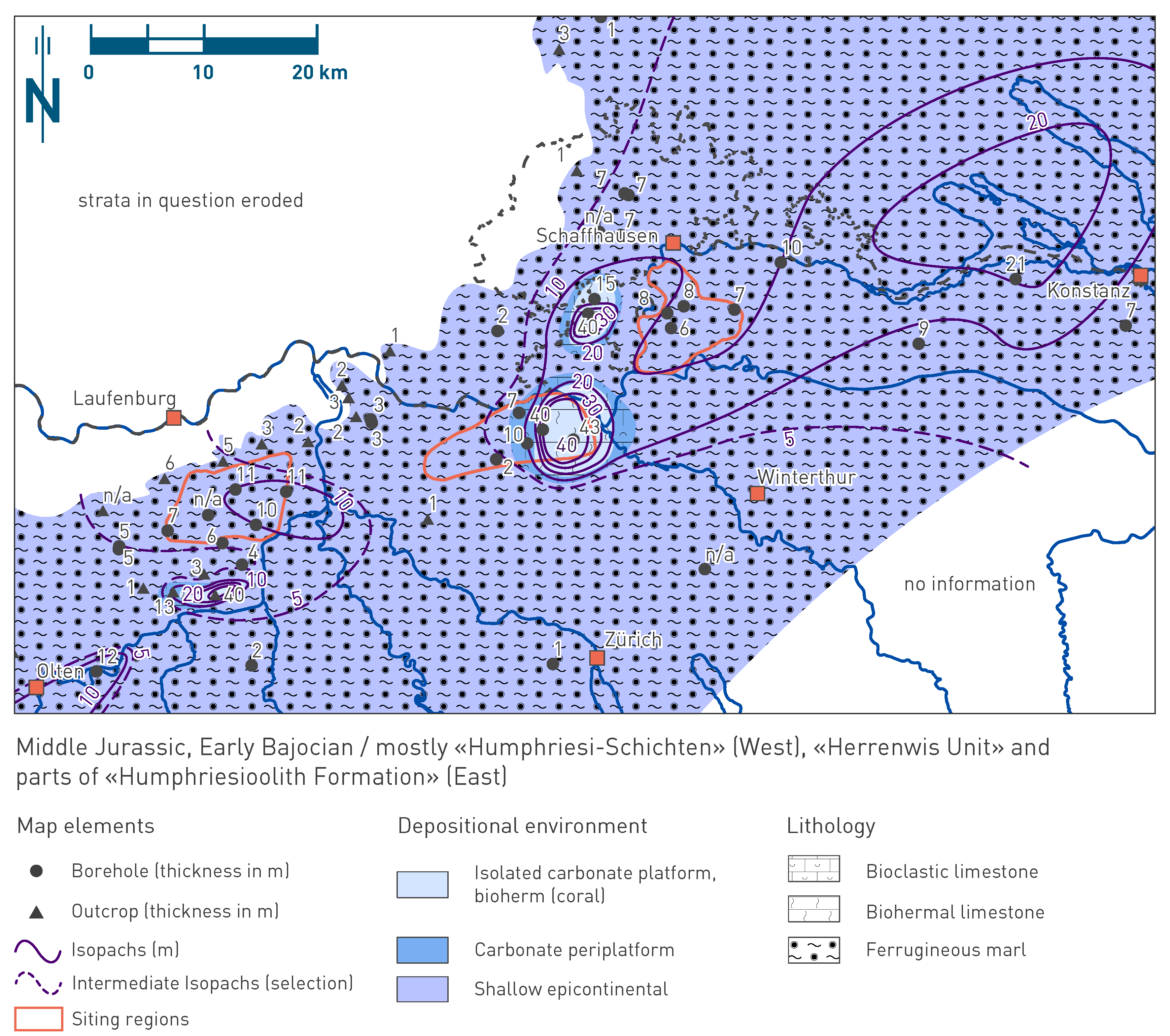
Fig. 4‑44:Map of depositional environments during the Early Bajocian
Refer to Fig. 4‑3 for a schematic representation of depositional environments. The north arrow refers to present-day geographic north. Map shows the setting during the "third time interval" (168.2_Baj_300 to 168.2_Baj_200) as discussed in the text.
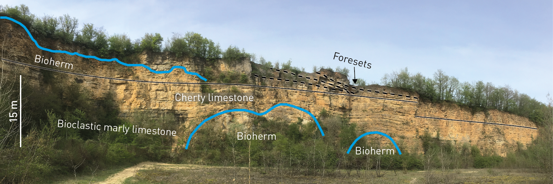
Fig. 4‑45:Bioherms at two levels (Calcaire à polypiers inférieur et supérieur) shown as a time-equivalent analogue for the bioherms of the «Herrenwis Unit»
Quarry near Malancourt-la-Montagne (Lorraine, France; see Geister & Lathuilière 1991; photo and interpretation by A. Ruchat).
The fourth time interval (168.2_Baj_200 to 154.8_Oxf_975) spans the Late Bajocian to Early Oxfordian (Fig. 4‑33, Fig. 4‑46). In JO it corresponds to the upper Passwang Formation, Hauptrogenstein, Klingnau and Ifenthal Formations. In NL and ZNO it corresponds to the «Parkinsoni-Württembergica-Schichten», Variansmergel and Wutach Formations. In JO the fourth time interval is dominated by the progression of the oolitic and bioclastic Celtic Platform (Hauptrogenstein) from the west (Fig. 3‑9). The carbonate platform interfingers to the east with a more basinal depositional environment, which is characterised by a mixture of calcareous input from the platform and siliciclastic "background" sedimentation in the basin. The Hauptrogenstein comprises three shallowing-upward successions, each capped by a hardground (Gonzalez & Wetzel 1996; Fig. 4‑35). Within these successions, the oolitic and bioclastic platform advances from west to east. This phase of the fourth time interval is dominated by high to very high sedimentation rates. This contrasts with the deposits of the overlying Ifenthal Formation that was formed during a time interval characterised by low to very low sedimentation rates (Fig. 4‑4). In NL the depositional environment of the fourth time interval must have been strongly influenced by the underlying «Herrenwis Unit». The basin west of the isolated carbonate platform was filled by mostly argillaceous sediments associated with high to very high sedimentation rates. This is corroborated by onlaps of the corresponding «Parkinsoni-Württembergica-Schichten» and Variansmergel Formation on the «Herrenwis Unit» as seen in seismic profiles (Fig. 4‑41). In the area above the isolated carbonate platform of the «Herrenwis Unit», this phase was characterised by non-deposition, condensation (hardgrounds) and episodes of minor argillaceous deposition, reflecting low to very low sedimentation rates. In ZNO the depositional environment during this time interval was similar to the conditions in western NL, with siliciclastic basinal deposition and high sedimentation rates. In JO, NL and ZNO, the fourth time interval ends with condensation, i.e. with a phase characterised by low to very low sedimentation rates (Wutach and Ifenthal Formations respectively; Fig. 4‑4, Fig. 4‑5 and Fig. 4‑6).
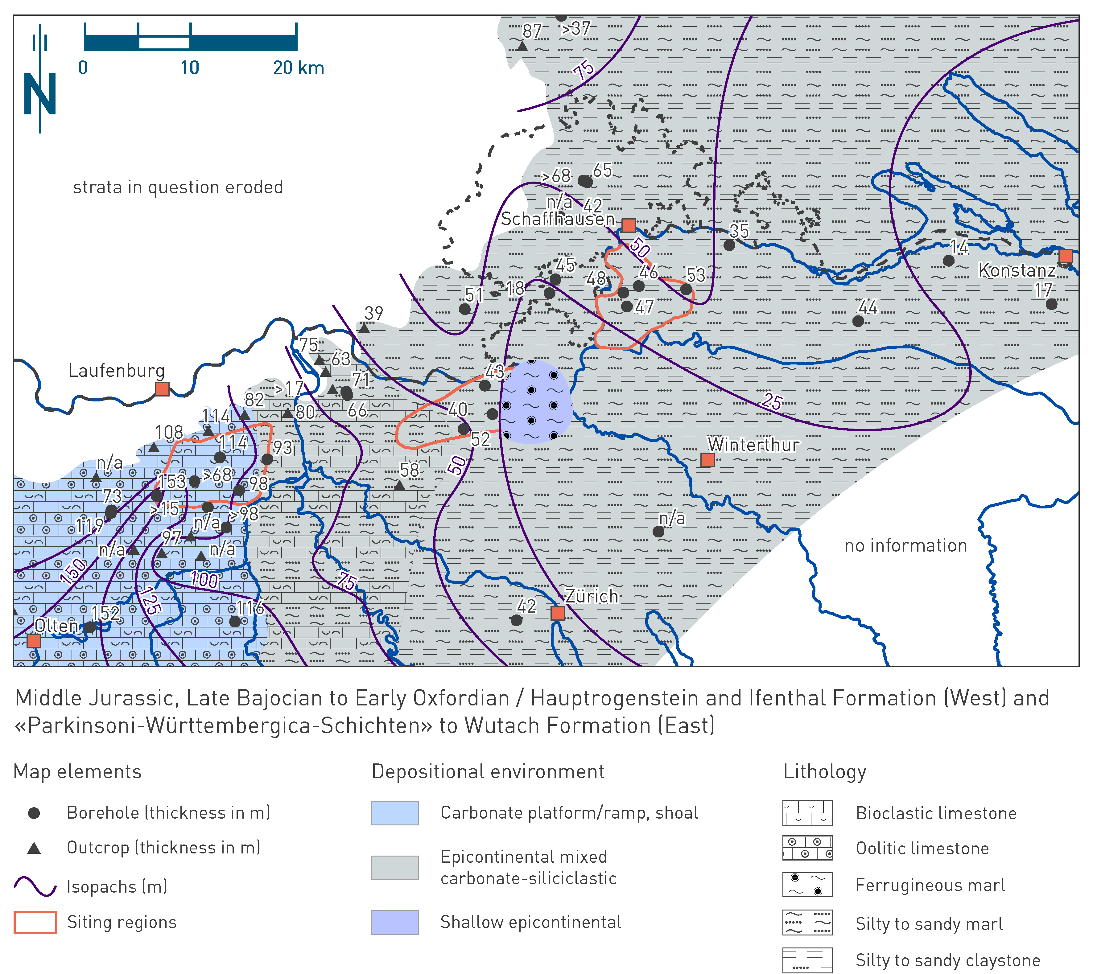
Fig. 4‑46:Map of depositional environments during Late Bajocian to Early Oxfordian
Refer to Fig. 4‑3 for a schematic representation of depositional environments. The north arrow refers to present-day geographic north. Map shows the setting during the "fourth time interval" (168.2_Baj_200 to 154.8_Oxf_975) as discussed in the text.