
The Middle Jurassic Opalinus Clay was deposited in a shallow epicontinental sea in a subtropical to tropical climate (Wetzel et al. 2003, Lauper 2021, Wetzel & Allia 2003). During the Middle Jurassic, Europe continued to be affected by the development of the Piemont – Liguria Ocean (Chapter 3). For the Early Aalenian, an overall regressive trend was suggested for the epicontinental Central European Basin (Lauper et al. 2021a, Zimmermann et al. 2018). The epicontinental sea was surrounded by the Rhenish Massif to the north, the Vindelician – Bohemian Massif to the east, the Alemannic Land to the south and the very shallow area in the Burgundy area to the west (Fig. 3‑8). Siliciclastic input to the epicontinental basin could have come from the nearby landmasses or long-distance transport from Fennoscandia. Absolute water depth was estimated to about 20 to 50 m (Allia 1996, Wetzel & Allia 2003), but may also have been deeper at least temporarily (Fig. 4‑31). The large accommodation space needed to deposit the thick Opalinus Clay in a relatively shallow water environment – particularly considering uncompacted sediment thicknesses – was provided by regional subsidence (Wetzel & Allia 2003). Subsidence led to a depositional environment that became differentiated into subtle swells and depressions, thought to have had an important impact on thickness and facies variations of the Opalinus Clay (Wetzel & Allia 2000, 2003, Lauper et al. 2021a).
The lower lithostratigraphic boundary of the Opalinus Clay coincides with the Toarcian-Aalenian boundary within the available biostratigraphic resolution in the study area in Northern Switzerland. Towards the west, in the Mont Terri rock laboratory, the deposition of the Opalinus Clay had already begun by the Late Toarcian (Hostettler et al. 2017). In general, the entire Opalinus Clay exhibits a shallowing-upward trend, with more homogeneous claystone at the bottom and increasing silt and fine sand towards the top, which may reflect the overall regressive trend observed in the Early Aalenian. Different authors have postulated additional cyclic facies trends such as coarsening-upward cycles ("Dachbankzyklen") (Allia 1996, Wetzel & Allia 2003, Lauper et al. 2021a, Leu et al. 2023). The intervals between the correlatable beds presented here (Fig. 4‑30) have been interpreted as coarsening-upward cycles that correspond to shallowing-upward regressive trends (Zimmerli et al. 2024). As pointed out earlier, the definition of such trends is more difficult in the lower and middle parts of the unit compared to the uppermost sectors; in the upper layers, calcareous and iron-rich beds are more common and can be correlated at local to regional scales. These beds appear to trace phases of reduced sedimentation and slight stagnation to condensation. The increased occurrence of these calcareous beds in the upper part could indicate that sedimentation rates decreased towards the top. Conversely, the sedimentation rates of the thicker, lower part of the Opalinus Clay were probably very high (Fig. 4‑4, Fig. 4‑5, Fig. 4‑6).
Zimmerli et al. (2024) defined an additional homogeneous/deformed subfacies 6 (SF6) characterised by homogenised, folded, deformed or tilted strata. It is interpreted to reflect mass-wasting events of different scales within the basin.
The more sandy-silty expression of the uppermost part of the Opalinus Clay as seen in the boreholes of JO could indicate an additional or stronger input of quartz- and feldspar-rich detritus (interval between marker bed Bed-V and Top Opalinus Clay; Fig. 4‑30). The upper boundary of the Opalinus Clay was correlated to a regression discontinuity (Burkhalter 1996). Lauper et al. (2021a) also identified the top of the Opalinus Clay as a diachronous discontinuity (Fig. 4‑34) and linked its genesis to sediment bypassing.
The Opalinus Clay is generally described as a tempestite-dominated deposit (Allia 1996, Wetzel & Allia 2003, Lauper et al. 2018; Fig. 4‑31a). During storm events, continental detritus and bioclastic elements were inferred to have been mobilised, reworked, and transported into the basin. In this model, coarser and finer lithologies reflect more proximal and distal tempestites, respectively. Depending on the position relative to the storm-wave base and bathymetry, facies and thickness variations developed. Modern analogues can be found in the North Sea and the Baltic Sea (Aigner & Reineck 1982, Milkert 1994, Wetzel & Allia 2003).
Recently, alternative depositional models have been postulated, including drift deposits (Zimmerli et al. 2024; Fig. 4‑31b). Drift deposits are in general fine-grained sedimentary bodies that develop due to the interaction of continuous bottom currents and bathymetry of the sea floor. Potential past analogues of such drift deposits exist, albeit in deeper settings, in the hemipelagic Early Jurassic Laurasian Seaway in the Cardigan Bay Basin, UK (Pieńkowski et al. 2021) or in the deposits of the Upper Jurassic/Lower Cretaceous Vaca Muerta Formation in the Argentine Neuquén Basin (Paz et al. 2022). Muddy shallow-water drifts (ca. 150 – 300 m) can for example be found on the south-western shelf of Mallorca (Verdicchio & Trincardi 2008, Vandorpe et al. 2011). The evidence for the occurrence of drift deposits on top of the Opalinus Clay below the «Herrenwis Unit» in a similar general setting (Section 4.2.7.5) supports the importance of currents for sediment transport and deposition in the environment of the Opalinus Clay.
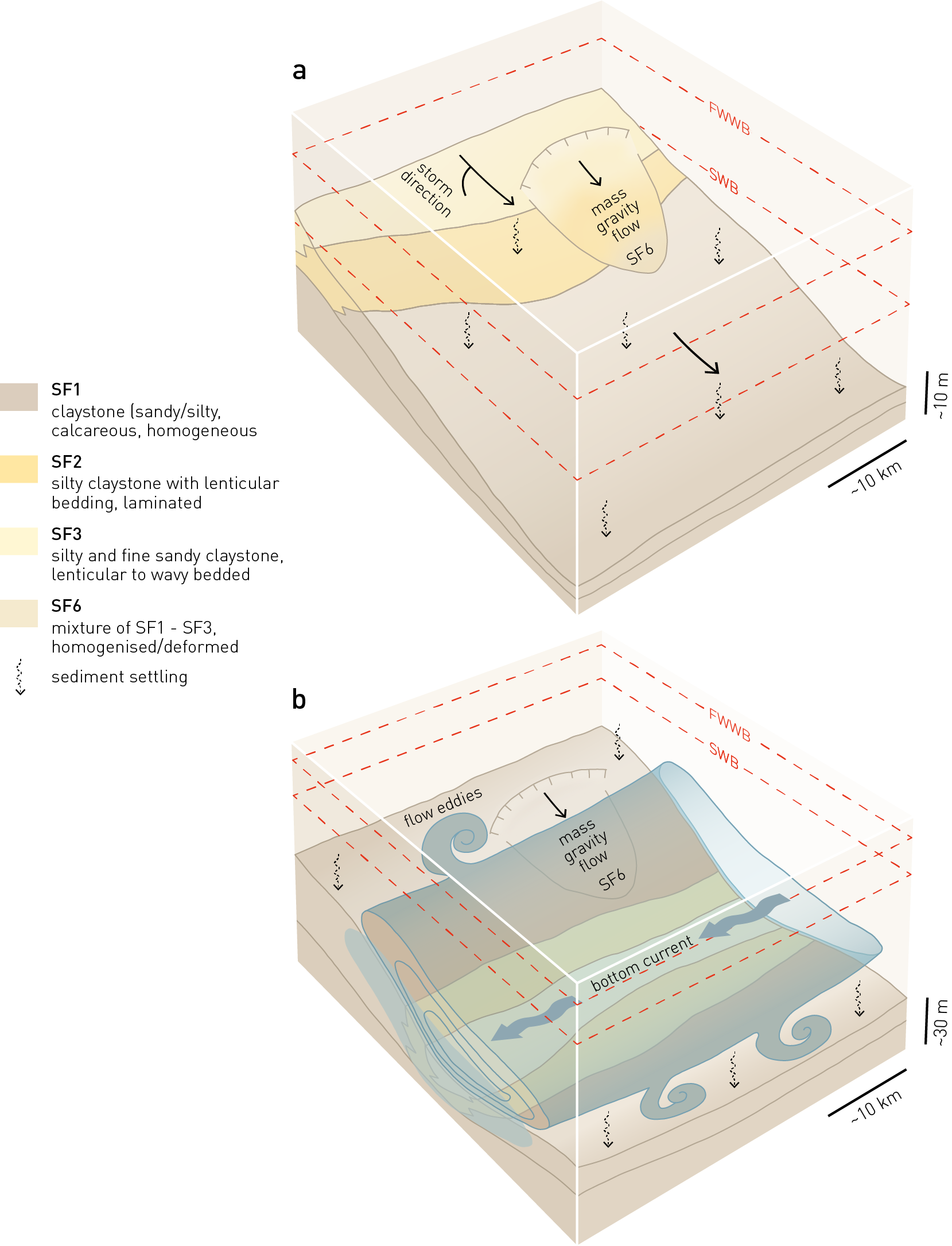
Fig. 4‑31:Block diagrams showing depositional models of the Opalinus Clay in Northern Switzerland
Sediment transport dominated by (a) storm events (tempestites) or (b) bottom currents (drift deposits). The depositional models are inspired by investigations of Lauper et al. (2018), Rebesco et al. (2014), Wetzel & Allia (1996, 2003) and Zimmerli et al. (2024). SF: subfacies, FWWB; fair-weather wave base, SWB; storm wave base.