
Key points:
- Temperatures in the Opalinus Clay and in the deep aquifers correlate well with depth below surface.
- In the siting regions, measured temperatures for mid Opalinus Clay are in the expected range from 28 °C (510 m below surface, borehole BOZ2) to 45 °C (940 m below surface, BUL1 borehole).
- For the aquifers, temperatures vary between 6 – 32 °C for mid Malm and 45 – 58 °C for mid Muschelkalk.
- Clay-mineral-rich units show considerably higher temperature gradients than limestones, reflecting the different thermal conductivities of the rocks.
- The new temperature data are in agreement with the expectations. The known anomalies southeast and northeast of the JO siting region can be explained by the local hydrogeo-logical and tectonic setting.
This section provides an overview of the temperature conditions in the three siting regions. Further information related to the geothermal conditions, including details on the thermal properties of the relevant units and on the thermo-hydraulic conditions at site scale, can be found in Nagra (2024w).
Formation temperatures have been obtained from wireline temperature logging performed in the BOZ1, BOZ2, BUL1, STA2, STA3, MAR1 and TRU1 TBO boreholes several months after borehole completion (see Tab. 2‑1 for references to the corresponding data reports). In addition, in the BOZ1, STA3 and MAR1 boreholes, long-term temperature monitoring systems were installed (Longridge et al. 2024). The temperatures show the expected depth dependence (Fig. 4‑135) with gradients dependent on the respective lithologies and, in the case of the potential aquifers, also possible flow (and hence transmissivities). The temperature profiles do not provide evidence for previously unknown significant transmissive zones.
For boreholes with a long-term monitoring system, geothermal gradients have been calculated under the assumption of a yearly average surface temperature of 10 °C, resulting in average gradients of 44 and 47 °C/km (BOZ1: 47 °C/km, STA3 and MAR1: 44 °C/km). These values are in the expected range for Northern Switzerland and there are no relevant site-specific differences.
Geothermal gradients within the lithological units correlate well between the boreholes. For the Opalinus Clay, the gradients are comparably high (7 – 7.5 °C/100 m). Such high gradients are typical for clay-rich rocks with a low thermal conductivity (~ 1.5 W/mK for the Opalinus Clay; Nagra 2024w), whereas carbonates display a low thermal gradient and high thermal conductivity (~ 4 W/mK for carbonates from the Muschelkalk aquifer; Nagra 2024w).
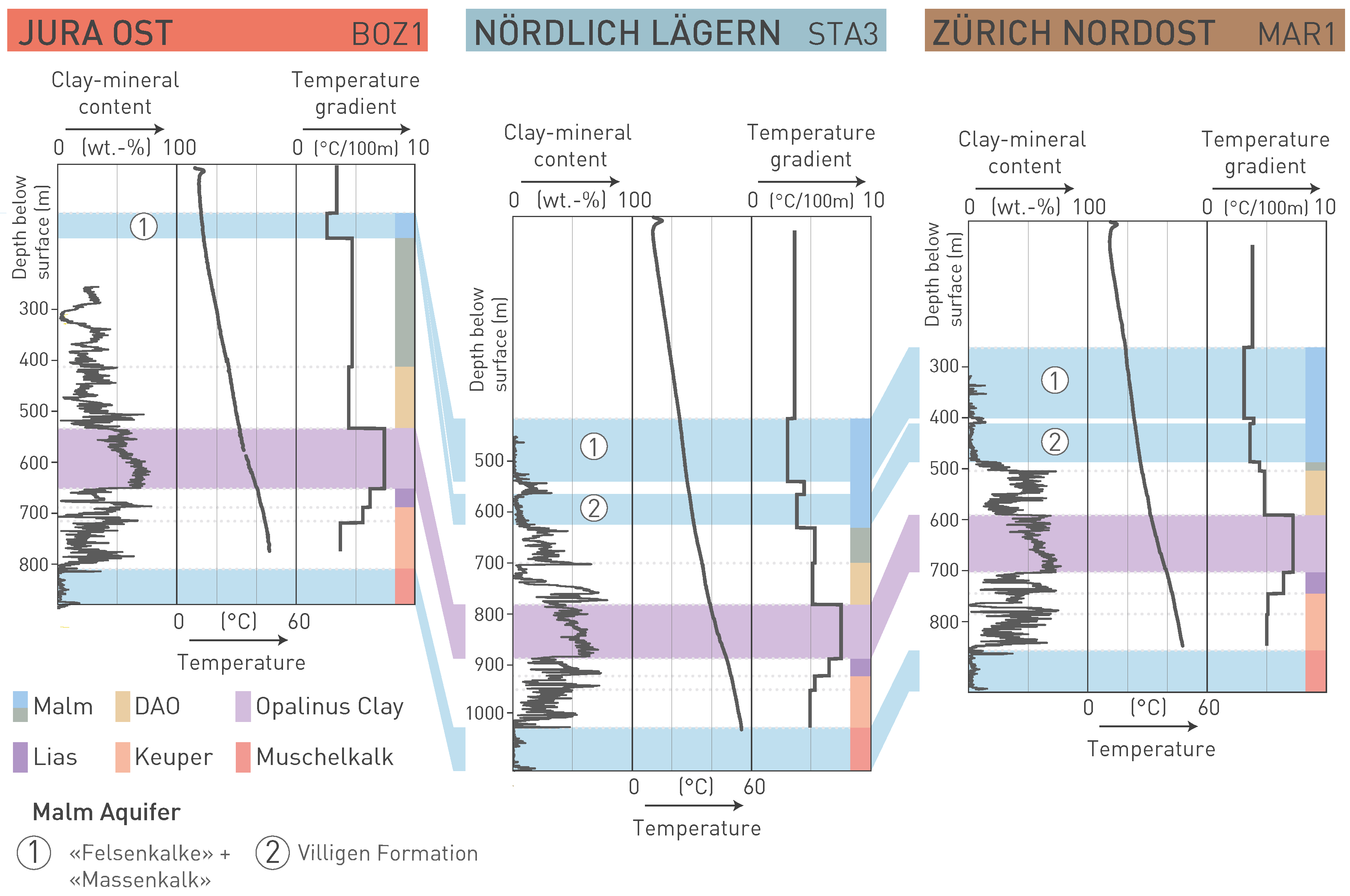
Fig. 4‑135:Temperature profiles and lithology-dependent temperature gradients
Shown here are temperature measurements from the fibre-optic long-term monitoring system together with calculated temperature gradients (for the borehole and for each unit) and the corresponding clay-mineral content. Note the increased temperature gradients in units with high clay-mineral contents.
Measured temperatures for mid Opalinus Clay in the siting regions correlate well with depth and range from 28 °C (510 m below surface, BOZ2 borehole) to 45 °C (940 m below surface, BUL1 borehole) (Fig. 4‑136). For mid Malm and mid Muschelkalk aquifers, the observed temperatures are 6 – 32 °C and 45 – 58 °C for, respectively (Fig. 4‑136).
The heatflow map of Northern Switzerland (Schärli & Rybach 2002, published in Nagra 2002), shows two distinct thermal anomalies:
-
The first anomaly is located south to southeast of JO, approximately between Baden and Schinznach. This anomaly is located along the Jura Main Thrust and the southern limit of the Konstanz – Frick Trough (Fig. 4‑55). Hydrogeologically, this zone reflects the regional discharge area for the Muschelkalk aquifer south of the Jura Main Thrust (Fig. 4‑102; Nagra 2024n). The upwelling thermal waters feed the well-known thermal springs of Baden and Bad Schinznach which are located where the Limmat and Aare cut through the easternmost Internal Jura.
-
The second anomaly is located to the northeast of JO, in the lower Aare Valley, just north of the Konstanz – Frick Trough. This is slightly to the south of the regional discharge area of the Muschelkalk aquifer for the flow system north of the Jura Main Thrust (Fig. 4‑102). In addition, it is an area with known upward-directed hydraulic gradients in the crystalline basement. These can be explained by recharge in the Black Forest hilly area and the overall low hydraulic conductivity of the Konstanz – Frick Trough preventing further southbound flow (Voborny et al. 1994). See Nagra (2014g, Dossier VII) and Rybach (2009) for further discussion.
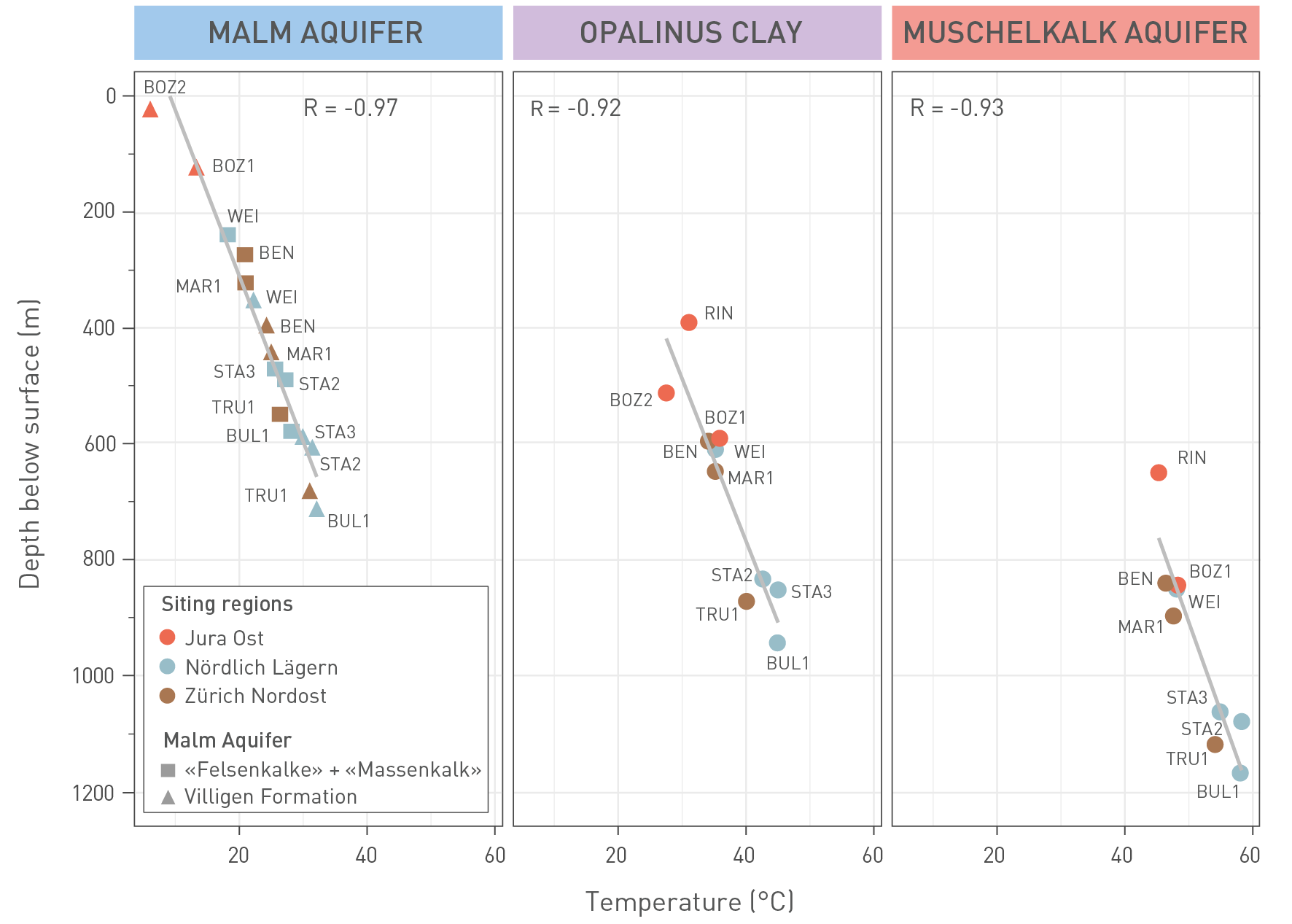
Fig. 4‑136:Cross-plots of temperature (°C) vs. depth below surface (m) for the Malm aquifer, Opalinus Clay and Muschelkalk aquifer
Data points are colour-coded according to the siting regions. Temperature values were taken from the centre of the respective unit. For the Muschelkalk aquifer of STA3, the given temperature corresponds to the top of the unit, as no data are available for the deeper part. Where data from the long-term monitoring system and temperature logging exist, the data from the long-term monitoring system were selected. Note that the value for the Malm aquifer in BOZ2 is influenced by seasonal temperature variation. The data show linear relationships between depth and temperature.
To conclude, these thermal anomalies can be explained by the local hydrogeological and tectonic setting favouring heat transport towards these zones. The situation in the potential disposal zones of the three siting regions is different. Here, the observed temperature profiles can be modelled reasonably well with a constant basal heat flow (Nagra 2024w).