
The Keuper Group consists mainly of low-permeability clay-rich rocks and evaporites. Only the Klettgau Formation in its upper part includes some transmissive lithologies. At the time of deposition, the study area was dominated by variable mostly terrestrial depositional environments, resulting in high variability of the deposited sediments and of their thickness (Section 4.2.4, Fig. 4‑15). This variability affects the hydrogeological properties of the potential aquifer units, with a variation of hydraulic test transmissivities over eight orders of magnitude (Fig. 4‑86). To address this variability and to make a distinction from the regional Malm and Muschelkalk aquifers, the term local aquifer is used (Nagra 1988, 2002).
The following section focuses on the potential aquifer units in the Klettgau Formation that are of particular interest for the siting regions in Northern Switzerland, i.e. the Seebi Member, the Gansingen Member and the Ergolz Member (Fig. 4‑94). In Southern Germany, additional units may be of interest (Plum et al. 2008). The Keuper aquifer is of particular relevance because it is the aquifer closest to a potential repository in the Opalinus Clay (JO: similar distance to the Hauptrogenstein).
In the JO siting region, the Keuper aquifer was sufficiently transmissive to sample groundwater (Section 4.5.5.4) in the RIN and BOZ2 boreholes (and also in the nearby Beznau borehole, BEZ), with a particularly high transmissivity in the range of 10-4 m2/s in BOZ2 (Fig. 4‑86). In BOZ1, low transmissivity was observed but the characteristic shape of the profiles of the natural tracers (notably stable isotopes of water and chloride) shows a clear excursion (Section 4.6). This means that there is evidence for an active Keuper aquifer in all of the boreholes of this siting region. Based on the hydrogeological dataset and taking into account lithology (Fig. 4‑15) and tectonic overprint, the permeability is most probably associated with the Gansingen Member which is particularly thick in JO. Groundwater flow probably occurs in fractures and may be facilitated by the partly well-developed macroporosity (Fig. 4‑16).
In the NL siting region, the test transmissivities of 2 × 10⁻⁷ and 1 × 10⁻⁶ m2/s in the BAC1 and STA2 boreholes allowed sampling of groundwater. In the other three boreholes, transmissivities were too low (range of 2 × 10⁻⁸ to 1 × 10⁻¹⁰ m2/s; Fig. 4‑86). In the case of the BUL1 and STA3 boreholes, the lower values are in line with an absence of significant excursions in the profiles of the natural tracers. From the packer test position and supported by other evidence, it is shown that the conductive zones relate to fluvial sandstone sections in the Ergolz Member. A particularly thick (ca. 7 m) quartz-rich channel was observed in the STA2 borehole (Fig. 4‑94). In NL, the other members of the Klettgau Formation have not been observed to significantly contribute to transmissivity, probably because of local lithofacies and thickness (Section 4.2.4 and Fig. 4‑95). In the Ergolz Member, the positive trend of transmissivity with quartz and feldspar content and intervals devoid of carbonate cement suggest that the matrix significantly contributes to overall transmissivity. The connectivity of the individual sandstone channels is probably limited as indicated by the differences in the hydrogeochemistry of the groundwater samples (Section 4.5.5.4) and by different extents of aquifer-aquitard interaction indicated by the profiles of the natural tracers in the BAC1 and STA2 boreholes (Section 4.6). Overall, the observations indicate that groundwater flow in NL is restricted to such channel systems and not as extensive as, for example, in the case of the Seebi Member in ZNO. The mostly low hydraulic test transmissivities in NL (Fig. 4‑86) are in line with the outcome of the calibration of the simplified representation of the Keuper aquifer in the hydrogeological model (Section 4.5.4.4).
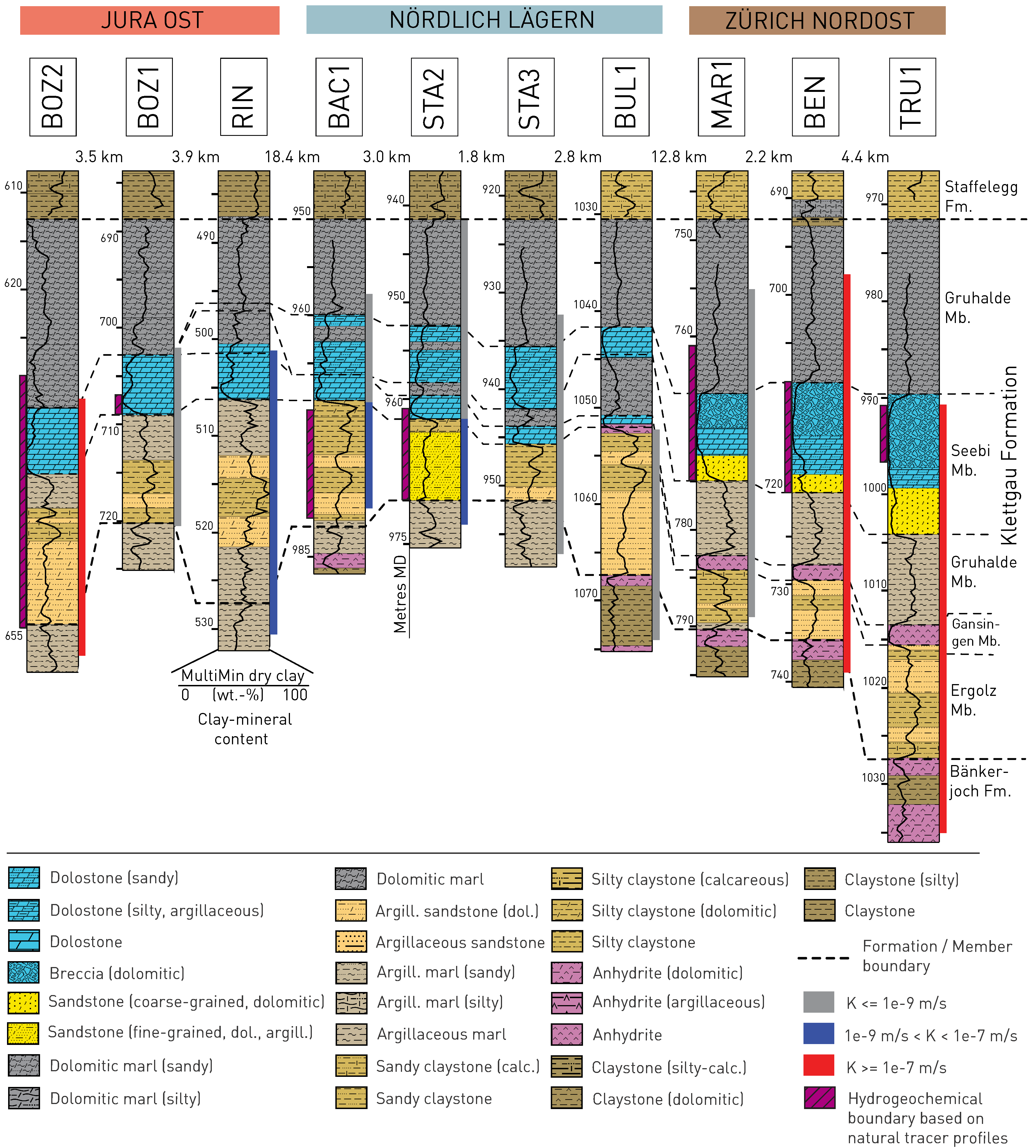
Fig. 4‑94:Results of the hydraulic packer testing and hydrogeochemical investigations in the Klettgau Formation
The vertical extents of the hydraulic packer tests are shown on the right of the stratigraphic profiles. The colour code refers to the magnitude of the hydraulic conductivity (see legend) calculated from the transmissivity and the length of the test intervals. The vertical extents of the hydrogeochemical boundaries as estimated based on observations on natural tracer profiles (and complemented by drill core observations) are displayed on the left of the stratigraphic profiles (purple hatched intervals). The latter represent the hydrogeochemical boundaries at the Keuper aquifer used for the modelling of the natural tracer profiles in the aquitards (Sections 4.6.2 and 4.6.3).
In the ZNO siting region, the new TBO boreholes confirmed the earlier investigations related to the Keuper aquifer as the major hydrogeochemical boundary for the Opalinus Clay. High test transmissivities (4 × 10⁻⁶ and 6 × 10⁻⁵ m2/s) allowed sampling of groundwater of similar composition from the Benken (BEN) and TRU1 boreholes (Section 4.5.5.4). In MAR1 the transmissivity was lower (1 × 10⁻⁸ m2/s; Fig. 4‑86), but the profiles of the natural tracers show a clear excursion with a characteristic change to a low-chloride meteoric composition (Section 4.6). The same systematic pattern was observed in the RHE1 borehole and also in the nearby Schlattingen-1 geothermal borehole (Wersin et al. 2016). Overall, the available hydrogeological dataset indicates there is an active Keuper aquifer across the entire ZNO siting region. The transmissive zone relates to the Seebi Member (former 'Stubensandstein') which exclusively includes in ZNO and the nearby areas a partly macroporous dolomitic breccia (Section 4.2.4).
At the regional level, permeable sandstone channels of the Ergolz Member must be expected in all the siting regions (Fig. 4‑95). They are of limited extent and occur only locally, but their position is difficult to predict. In contrast, the permeable, cavernous dolomitic breccia of the Seebi Member is a particular feature of ZNO, and the thick Gansingen Member exists in JO.
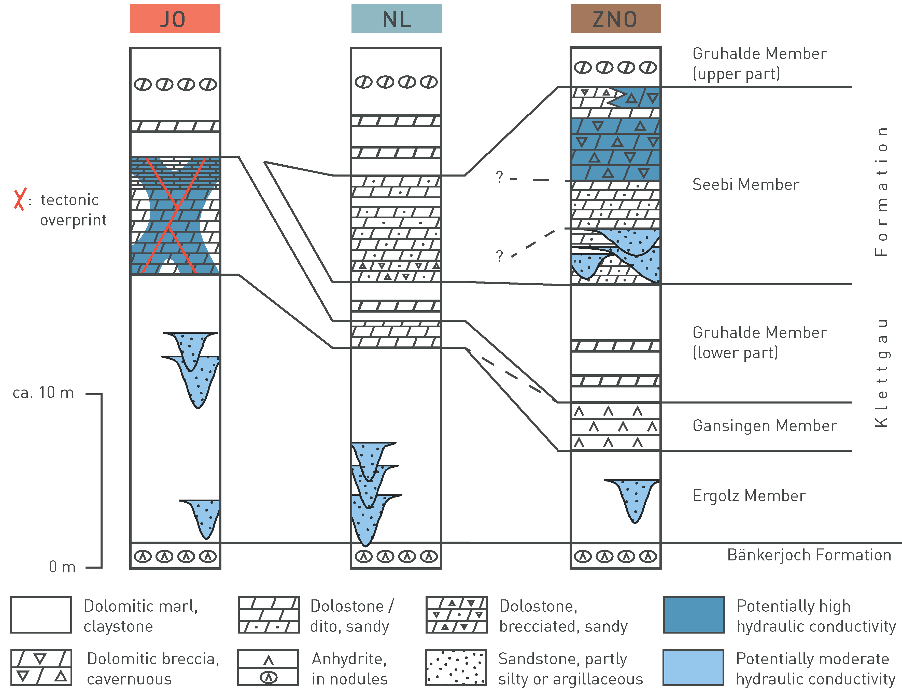
Fig. 4‑95:Hydrogeological synopsis of the Keuper aquifer indicating the permeable lithofacies of the Klettgau Formation in the different siting regions