
This section summarises important findings of Chapter 4. Observations from deep boreholes and key parameters are compiled site-specifically by projection to a reference borehole (Fig. 4‑137, Fig. 4‑138, Fig. 4‑139). This forms the basis for the site-specific delineation of the low-permeability confining units (Fig. 4‑140).
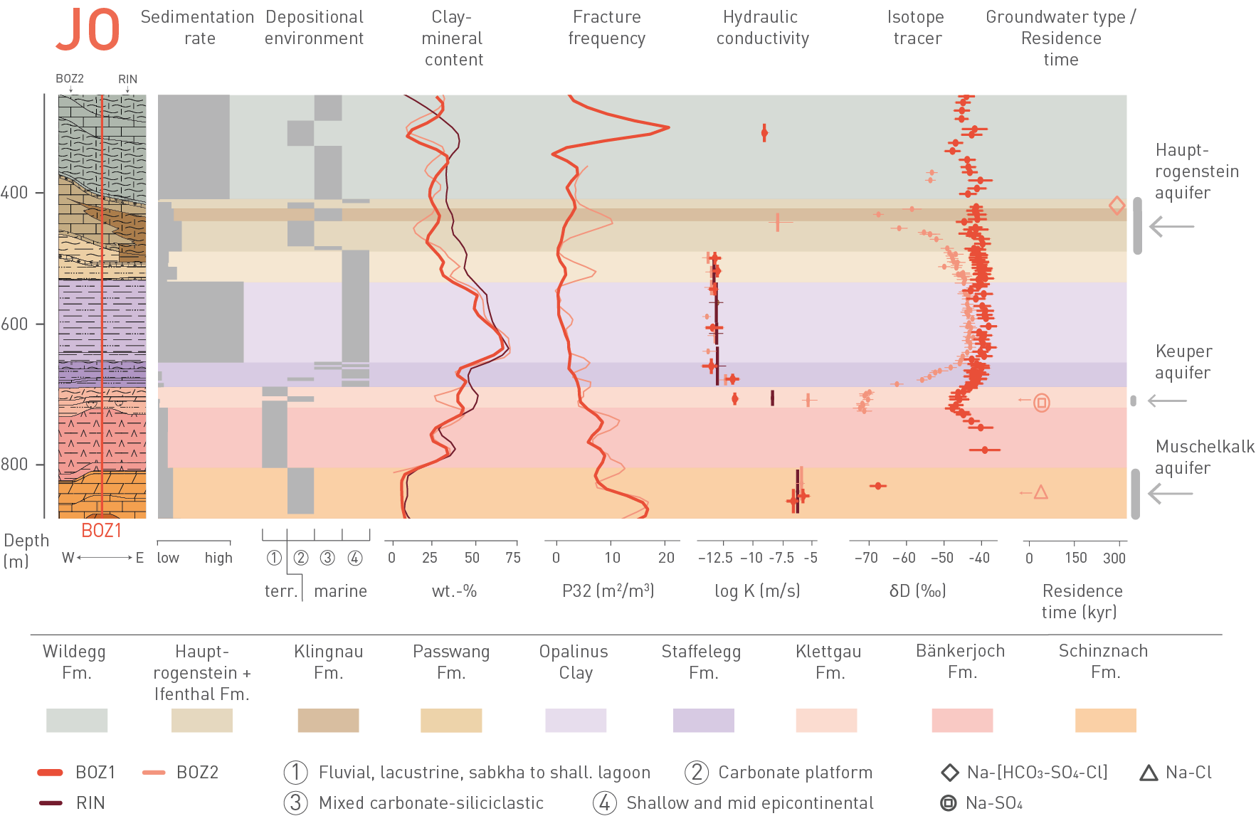
Fig. 4‑137:Key observations between Muschelkalk and Hauptrogenstein aquifers in JO
Data from the BOZ2 and RIN boreholes are projected to the reference borehole BOZ1. The arrows next to the groundwater symbols indicate maximum residence times. Fracture frequency and clay-mineral-content regression lines were smoothed with a moving average. shall.: shallow.
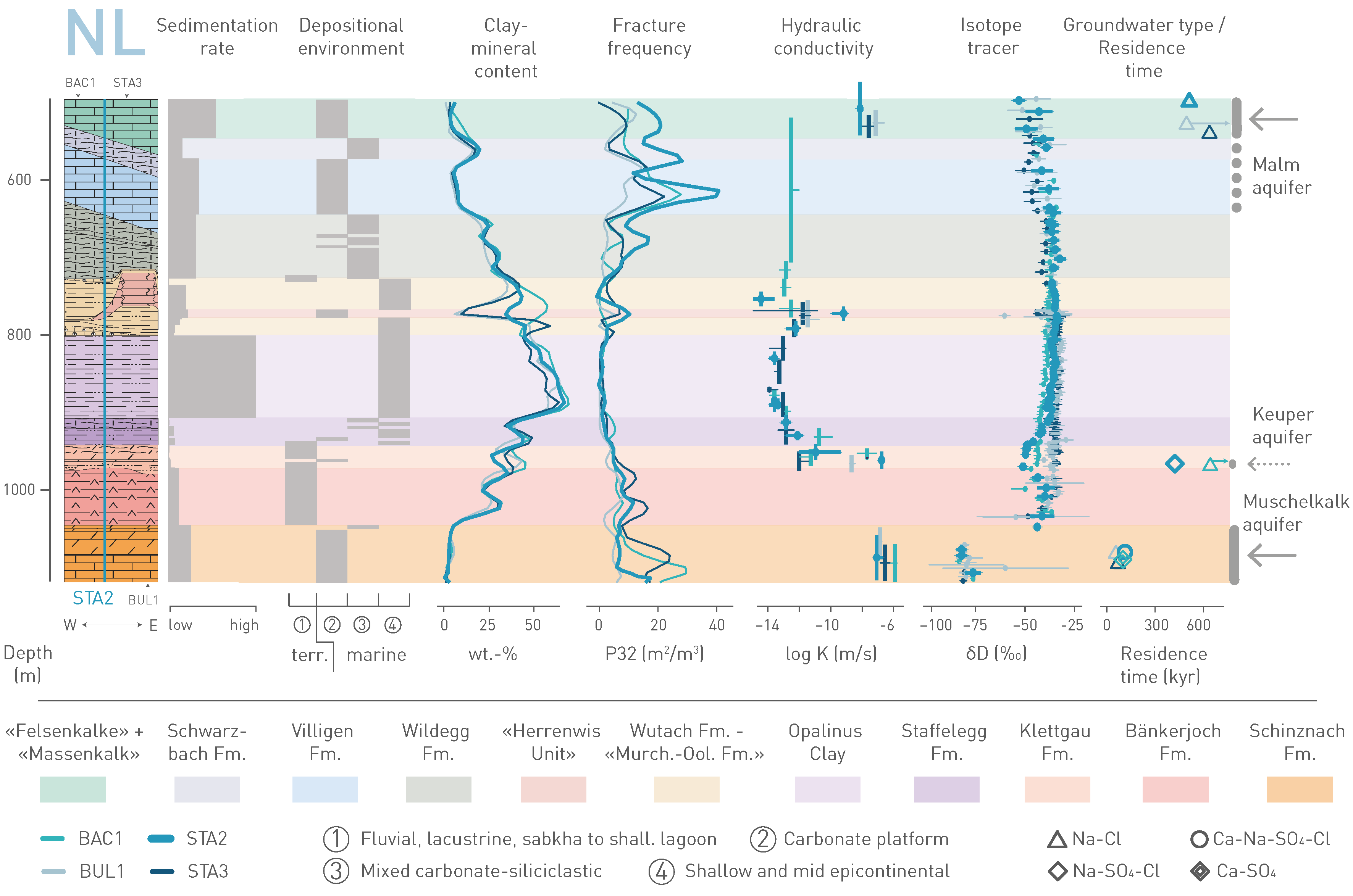
Fig. 4‑138:Key observations between Muschelkalk and Malm aquifers in NL
Data from the BAC1, BUL1 and STA3 boreholes are projected to the reference borehole STA2. The arrows next to the groundwater symbols indicate minimum residence times. Fracture frequency and clay-mineral-content regression lines were smoothed with a moving average. shall.: shallow.
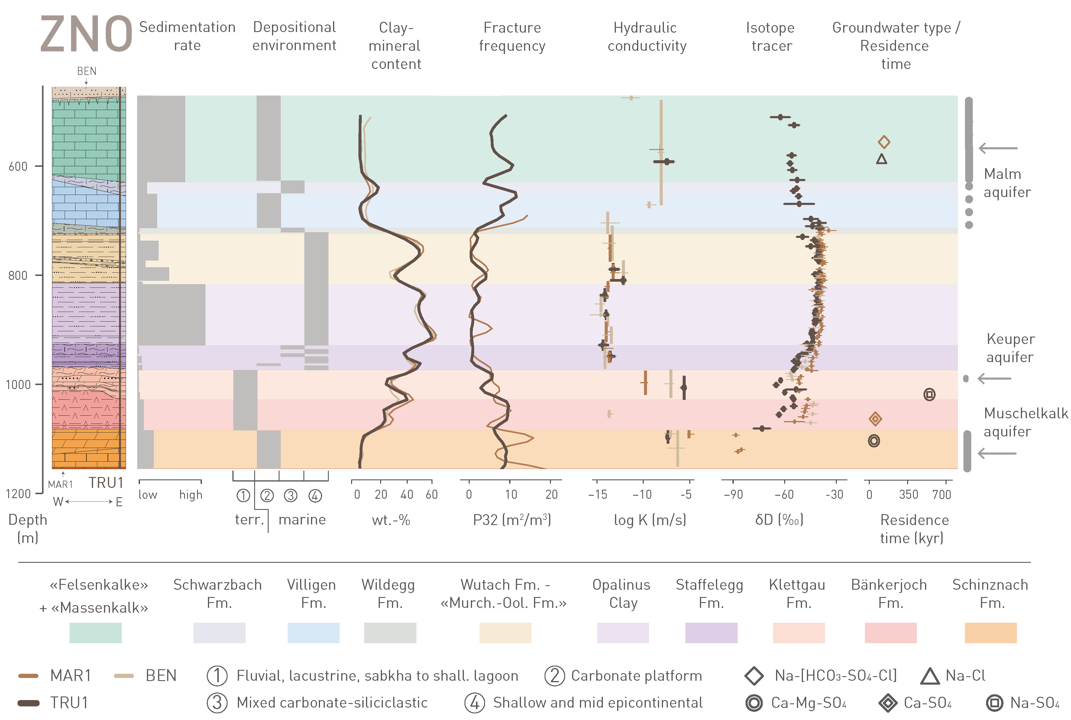
Fig. 4‑139:Key observations between Muschelkalk and Malm aquifers in ZNO
Data from the MAR1 and BEN boreholes are projected to the reference borehole TRU1. Fracture frequency and clay-mineral-content regression lines were smoothed with a moving average. shall.: shallow.
With regard to the barrier function, the geological units presented in Fig. 4‑137, Fig. 4‑138 and Fig. 4‑139 can be allocated to three groups with similar characteristics: Host rock, low-permeability confining units and deep aquifers:
-
The Opalinus Clay host rock is the core of the transport barrier. It is characterised by a small lateral variability compared to other Mesozoic formations in Northern Switzerland. This is related to the depositional environment represented by a shallow epicontinental sea with a high clay-mineral input (comparably high sedimentation rates). The general subfacies succession can be correlated between all boreholes across the siting regions. The fracture frequency is lower compared to more competent units. Numerous hydraulic packer tests demonstrate a very low hydraulic conductivity. This is consistent with the straight profiles of isotope tracers, with no indications for localised flow.
-
Above and below the host rock, the natural barrier is complemented by low-permeability confining units in all the siting regions. Overall, these show characteristics similar to the host rock, but with greater lithological heterogeneity (e.g. intercalated sandy and calcareous beds) and larger differences between the siting regions, particularly in the Dogger Group above Opalinus Clay. For example, the clay-mineral-rich units directly above the Opalinus Clay include more calcareous and sandy beds in JO and ZNO compared to NL and are generally more clay-mineral-rich in NL. In the eastern part of NL, particularly clay-mineral-rich units are overlain by a ca. 40 m thick isolated carbonate platform («Herrenwis Unit»). The lithological differences in the confining units reflect local changes in the depositional environment, which were strongly influenced by bottom currents. The clay-mineral content in the confining units is more variable but, overall, still high. This favours a more ductile deformation behaviour and is consistent with low overall fracture frequency, as observed in the Opalinus Clay. The hydraulic tests show low hydraulic conductivities, which is consistent with the shape of tracer profiles with no indication for groundwater flow. This indicates diffusion-dominated transport in the host rock and confining units over long timescales.
-
The confining units are bounded at the top and at the base by deep aquifers. The situation differs across the siting regions:
JO: The low-permeability zone is located between the regional Hauptrogenstein aquifer and the local Keuper aquifer. The carbonate platform of the Hauptrogenstein, known as a regional aquifer further to the west, extends into the JO siting region. This is demonstrated by the measured enhanced hydraulic conductivities and by the shape of the natural tracer profiles in the BOZ2 borehole. To the east, there is a facies transition to the clay-mineral-rich Klingnau Formation. Probably related to the facies transition, no transmissive section was drilled in the eastern boreholes (RIN and BOZ1). Residence times of the groundwater sample of the BOZ2 borehole is high, but the salinity and the water isotope composition indicate more interaction with meteoric waters in the past compared to most of samples from the Malm aquifer in NL and ZNO. The lower confining units are bounded by the Keuper aquifer, which is probably linked to the fractured dolomitic Gansingen Member, as indicated by hydraulic tests and tracer profiles. The 81Kr model age for the BOZ2 Keuper aquifer groundwater are low, probably due to sampling close to the recharge area.
NL: The regional Malm and the local Keuper aquifer, which was observed in some boreholes only, define the vertical extent of the low-permeability zone. In the stiffer limestone units of the Malm Group, fracture frequencies are higher compared to the weaker units below (e.g. the Opalinus Clay, Staffelegg Formation). The hydraulic tests indicate water flow related to fractures, mainly in the upper part of the limestone series («Felsenkalke» and «Massenkalk»). The Malm groundwaters contain varying contents of fossil Na-Cl water of marine origin. In NL, the marine component is particularly large and, together with long groundwater residence times, indicates quasi-stagnant conditions. In contrast to the other siting regions, indications for water flow in the Keuper aquifer are limited to sandstone channels (Ergolz Member), which only occur locally. Indications for enhanced hydraulic conductivities were only observed in two boreholes, however, with high groundwater residence times. The very local occurrence of the Keuper aquifer means that it is possible that stratigraphically deeper units, down to the Muschelkalk aquifer, contribute to the barrier function in NL (potential additional confining units in Fig. 4‑140).
ZNO: The low permeability zone is delimited by the Malm and the Keuper aquifers, respectively. As in NL, water flow in the Malm aquifer is related to fractures and is located mainly in the upper part («Felsenkalke» and «Massenkalk»). The water isotopic composition and the residence times indicate a slightly more active system compared to NL, particularly in the eastern part which is characterised by lower overburden thickness. In the Keuper aquifer, there are consistent indications for water flow in the Seebi Member from all boreholes in this area (hydraulic tests and/or tracer profiles). The Seebi Member is relatively thick in ZNO and includes a porous dolomitic breccia and sandstones. Groundwater residence times are large.
The regional Muschelkalk aquifer occurs in all the siting regions and represents the most dynamic flow system as demonstrated by comparably high hydraulic conductivities, clear signatures in tracer profiles and comparably low groundwater residence times.
A comparison of the lithological and hydrogeological situation between the three siting regions is shown in Fig. 4‑140. Regarding the barrier efficiency, the thickness of the host rock and confining units is an important characteristic. The distance between the centre of the host rock and the next overlying aquifer is largest in NL and smallest in JO. The distance between the centre of the host rock to the closest underlying aquifer (Keuper aquifer) delimiting the lower confining units is similar in all the siting regions. However, because of the peculiar, very local nature of the Keuper aquifer in NL, the units down to the Muschelkalk aquifer could contribute to the barrier function.
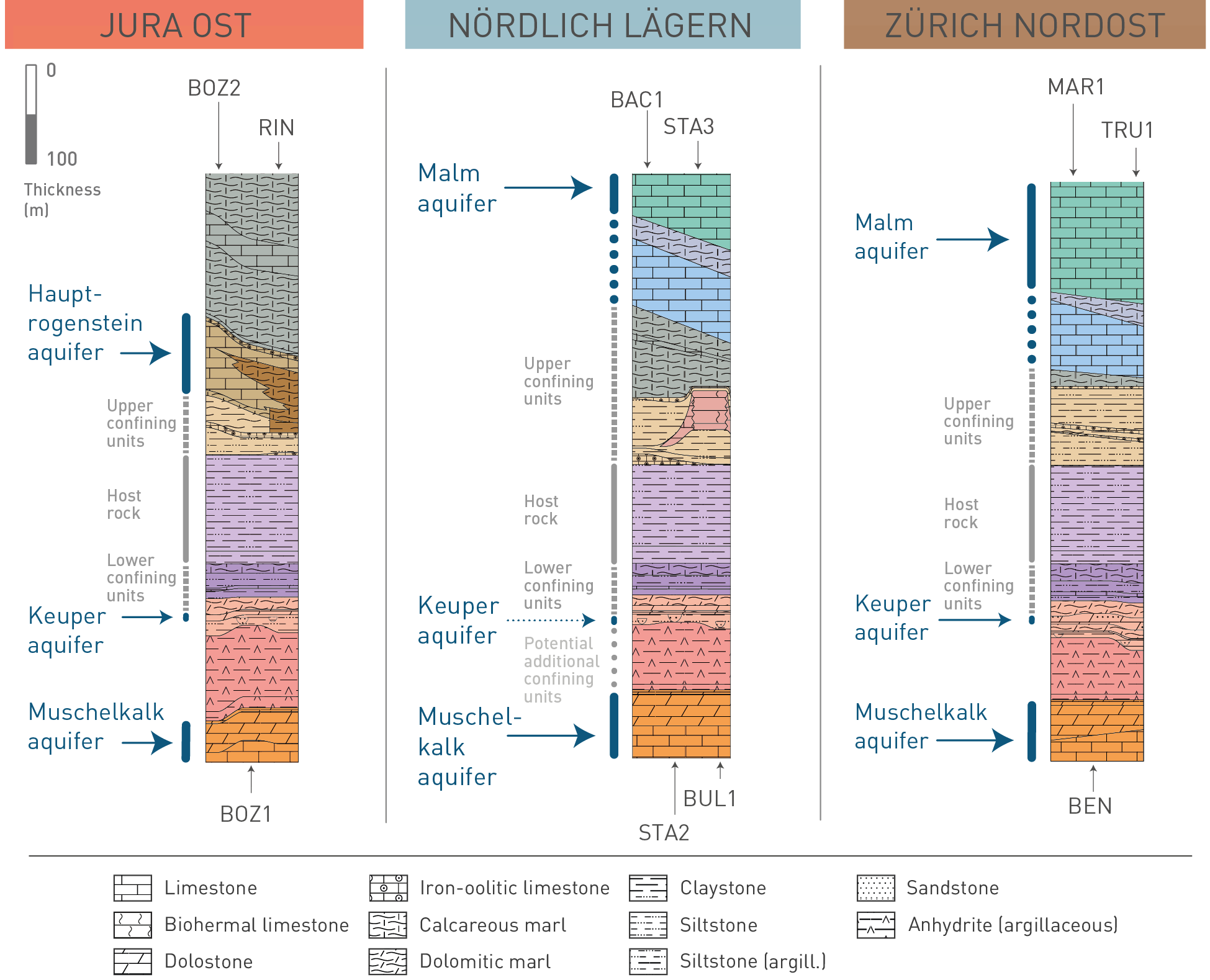
Fig. 4‑140:Extent of host rock and low-permeability confining units and location of neighbouring aquifers for the JO, NL and ZNO siting regions
Key datasets guiding the extent of the host rock and confining units are shown in Fig. 4‑137, Fig. 4‑138 and Fig. 4‑139. Note that the distance between the centre of the host rock and the next aquifer above is largest in NL. The distance to the lower aquifer is similar in all the siting regions. As a result of the peculiar, much more local nature of the Keuper aquifer in NL (see discussion in text), the anhydrite- and clay-mineral-rich units of the lower Keuper may contribute to the barrier function as additional confining units.
Besides these observations, the following aspects discussed in Chapter 4 are regarded as particularly relevant:
-
With respect to the lateral extent of the potential repository zone and the flexibility for the placement of the disposal areas, all the siting regions show areas devoid of seismically mappable faults. In NL this area is the largest.
-
The geological past provided numerous evidence for reactivation of larger structures, such as the regional fault zones, during later deformation episodes. This preference to reactivate pre-existing structures over the formation of new faults is anticipated to continue in future (Section 6.2).
-
Present-day orientation of SHmax was confirmed and is roughly NNW-SSE-trending in all the siting regions. The orientation of SHmax across the entire Mesozoic sequence and especially across the evaporitic units and the Opalinus Clay is indicative of a relatively stable present-day stress field.
-
Overall, the independent evidence gained from ground- and porewater investigations provides valuable insights into the past transport processes in the aquitard/aquifer system in the siting regions over timescales spanning several orders of magnitudes (ca. 104 to 107 years). In all the siting regions, the barrier efficiency is demonstrated by the profiles of natural tracers in porewater, which are best explained by molecular diffusion being the dominant transport mechanism. The isotopic composition of the Opalinus Clay porewater indicates a larger fraction of old porewater and a smaller overprint by meteoric water in NL, compared to the other siting regions.
-
The high contents of the noble gas isotope 4He in Opalinus Clay porewater demonstrate the strong barrier efficiency: Concentrations are more than 4 orders of magnitude higher than for air-saturated water. More than 65% of the He produced in Opalinus Clay since deposition is still present.
-
The study of mineral-filled fractures ('veins') indicates the evolution of the mineral-forming fluids from modified seawater-type prior to the Eocene times towards more meteoric waters in the Cenozoic. This trend resulted from subaerial exposure since at least Eocene times, which led to karstification in the top of the Malm Group, deposition of the Bohnerz Formation (Siderolithic Group) and downward migration of meteoric surface waters. The investigated veins in the Opalinus Clay were precipitated from fluids with less negative δ18O values than today’s porewater at higher temperatures. This suggests vein formation prior to Pliocene cooling.
-
Temperatures in the Opalinus Clay and in the Malm and Muschelkalk aquifers correlate well with depth below surface. In the siting regions, no distinct local temperature anomalies are indicated by the new boreholes and by comparison with temperature modelling. The previously known local temperature anomalies in the lower Aare Valley are restricted to the southeast and to the northeast of the JO siting region and can be explained by the local hydrogeological and tectonic setting (probable heat transport in the Muschelkalk aquifer and along basement faults).