
As elaborated in Chapter 3, the study area is situated in the North Alpine Foreland. The siting regions sit between the Upper Rhine Graben in the west, the Hegau – Bodensee Graben in the northeast and the Jura Fold-and-Thrust Belt in the south (Fig. 4‑54). In addition, Jura Ost and Nördlich Lägern are located above the Konstanz – Frick Trough, whereas Zürich Nordost is mostly north of it. As the regional tectonic domains strongly control the structural inventory encountered in the siting regions, they are introduced below.
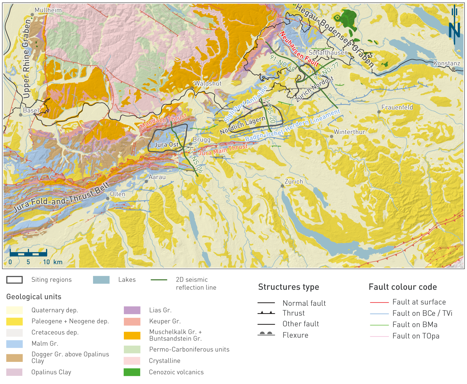
Fig. 4‑54:Geological map of Northern Switzerland with the siting regions and major faults
Geological units from 1:500'000 geological map with the addition of the Opalinus Clay outcrops in Northern Switzerland (©swisstopo). Fault traces from seismic interpretation are based on 2D seismic reflection (Madritsch et al. 2013, Meier et al. 2014) and 3D seismic reflection interpretation (Nagra 2024a, 2024b, 2024c). They are shown on the highest stratigraphic horizon where the specific fault segment was picked (different colours in the map view). Only horizons from Top Opalinus Clay and higher stratigraphic levels are shown. Note that only a selection of the structures from 3D seismic interpretation is shown to highlight the structural trends of regional importance. See Fig. 4‑61, Fig. 4‑65 and Fig. 4‑69 for the complete fault pattern.
Konstanz – Frick Trough (Permo-Carboniferous Trough)
The oldest tectonic domain, thought to have acted as an inherited zone of crustal weakness for an extended period of time, is the so-called Konstanz – Frick Trough, which is a graben filled with Permo-Carboniferous sedimentary rocks (Chapter 3). Available knowledge on the buried Konstanz – Frick Trough is derived from boreholes, 2D seismic reflection lines and 3D seismic reflection surveys (e.g. Diebold et al. 1991, Marchant et al. 2005, Madritsch et al. 2013, Naef & Madritsch 2014). Despite extensive subsurface data across the area under consideration, the robustness of the delimitation of the Konstanz – Frick Trough varies considerably (Madritsch et al. 2018). Its northern boundary is well constrained by boreholes, seismic reflection data and outcrops of crystalline basement in the neighbouring Black Forest Massif. The southern boundary is less well defined. It is suspected to roughly coincide with the front of the Internal Jura (Diebold & Noack 1997, Laubscher 1985, Malz et al. 2016). A tentative map of potential Carboniferous troughs underneath the entire Swiss Molasse Basin was presented by Leu (2008).
The Konstanz – Frick Trough is subdivided into a western segment (between Frick and the lower Aare Valley) and an eastern segment (east of the lower Aare Valley; Diebold et al. 1991). The transition between the two segments occurs across a system of NW-SE-trending faults (Fig. 4‑55, Vorwald Fault). The western segment is characterised by a wider and deeper central depocentre, whereas the eastern segment has wider trough shoulders with decreased sedimentary infill. JO is located above the western segment, whereas NL and the S-SW corner of ZNO are located above the eastern segment (Fig. 4‑55). The transition between the western and eastern segments occurring around an inherited fault system provides evidence for the major control exerted by such inherited faults – and by the pre-structured basement in general – on later deformation.
The main understanding of the tectonic evolution of the Konstanz – Frick Trough derives from the analysis of its sedimentary filling. From this, a three-stage subsidence history has been proposed (Diebold et al. 1991). Late Carboniferous deposition of organic-rich sediments was followed by the main subsidence phase in the Early Permian (~ 295 Ma onwards; Madritsch et al. 2018). Deposition of Late Permian sediments occurred during the late- to post-rifting stages of trough formation (~ 265 Ma).
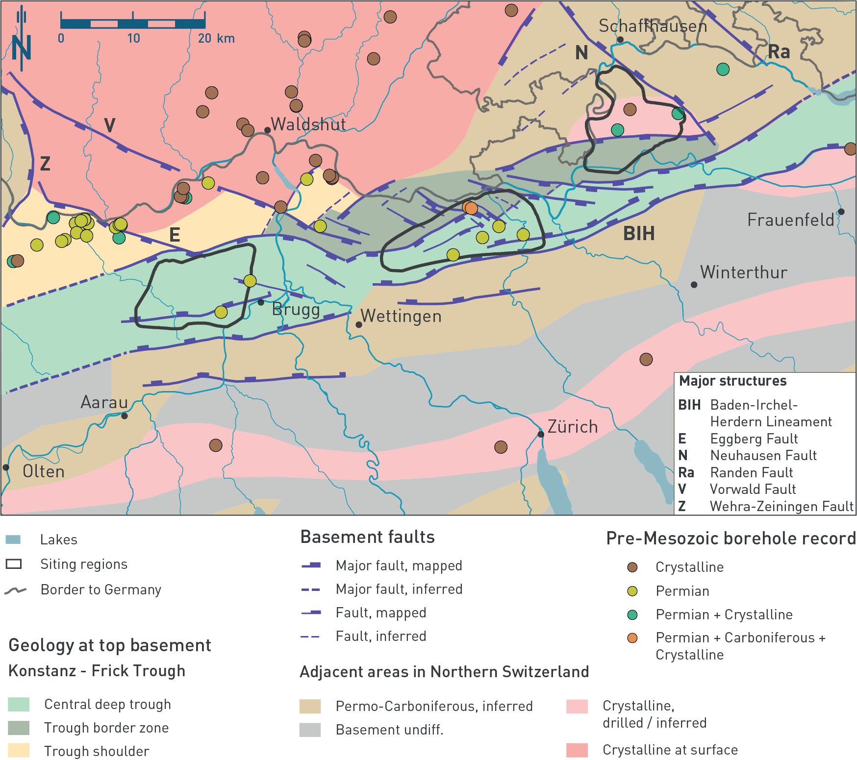
Fig. 4‑55:Conceptual tectonic map at top basement showing the main faults and the extent of the Konstanz – Frick Trough
Modified after Madritsch et al. (2018) and Naef & Madritsch (2014). The borehole symbol refers to the pre-Mesozoic record encountered in the borehole.
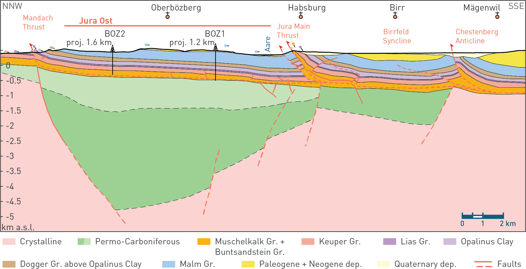
Fig. 4‑56:Large-scale geological cross-section through Jura Ost
Geological section drawn along the 2D seismic reflection line 11-NS-06. Section trace located in Fig. 4‑54. The section is based on Meier et al. (2014). Results from 3D seismic reflection interpretation were integrated within the 3D seismic perimeter (Nagra 2024a). The symbols above the topographic profile indicate bedding dip measured in nearby outcrops. Gr.: Group, Dep.: deposits.
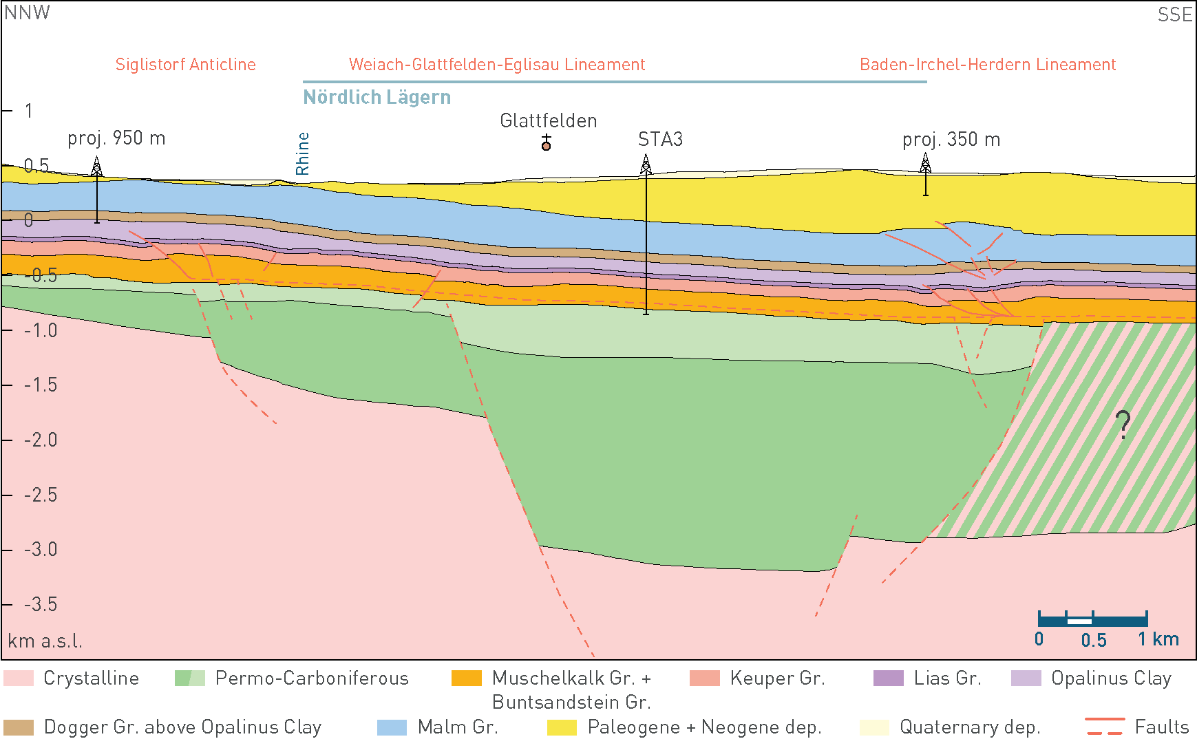
Fig. 4‑57:Large-scale geological cross-section through Nördlich Lägern
Geological section drawn along the 2D seismic reflection line 11-NS-20. Section trace located in Fig. 4‑54. The section is based on Meier et al. (2014) and Jordan et al. (2015). Results from 3D seismic reflection interpretation were integrated within the seismic perimeter (Nagra 2024b). Gr.: Group, Dep.: deposits. Green hatched area refers to either crystalline or Permo-Carboniferous deposits.
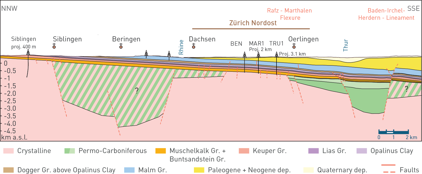
Fig. 4‑58:NNW-SSE large-scale geological cross-section through Zürich Nordost
Geological section drawn along the 2D seismic reflection line 91-NO-68. Section trace located in Fig. 4‑54. The section is based on Meier et al. (2014) and Jordan et al. (2015). Results from 3D seismic reflection interpretation were integrated within the seismic perimeter (Nagra 2024c). Gr.: Group, Dep.: deposits. Green hatched area refers to either crystalline or Permo-Carboniferous deposits.
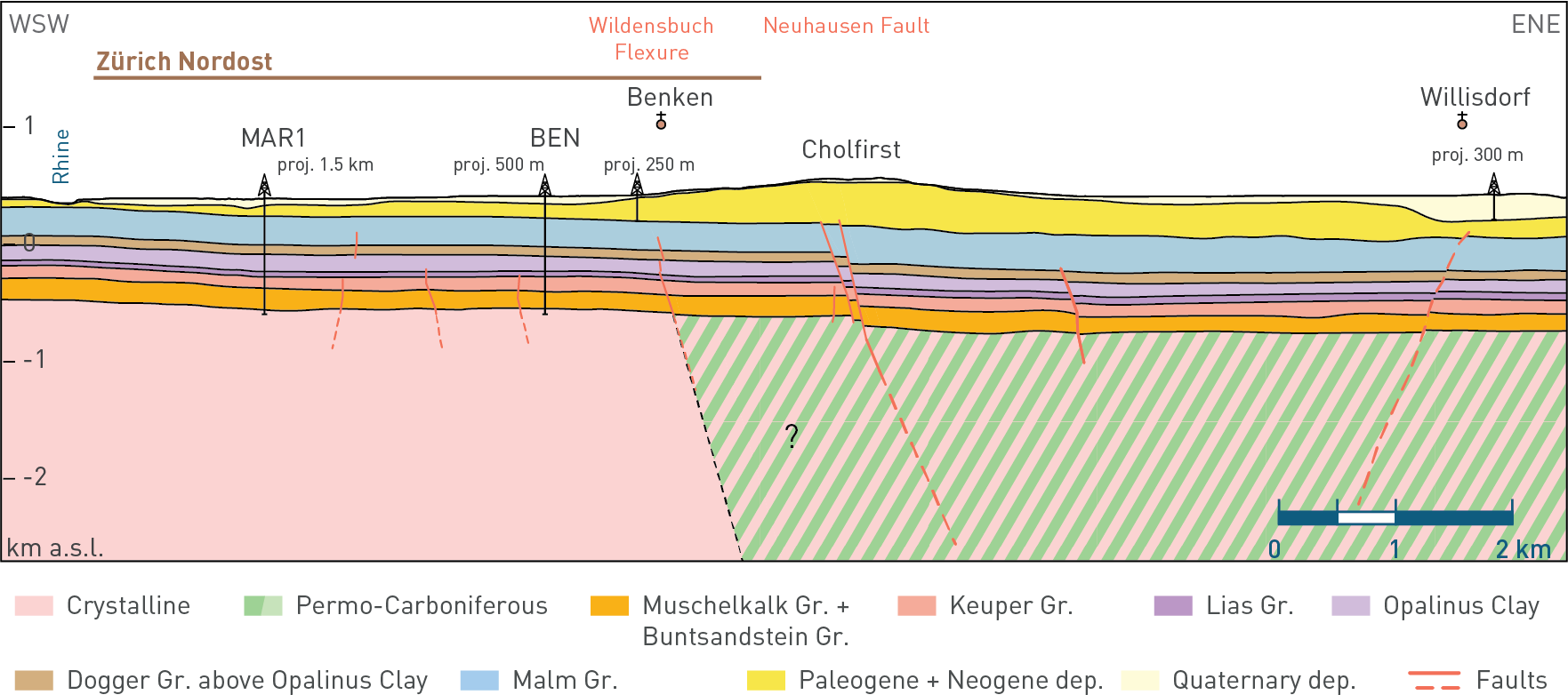
Fig. 4‑59:WSW-ENE large-scale geological cross-section through Zürich Nordost
Geological section drawn along the 2D seismic reflection line 91-NO-77. Section trace located in Fig. 4‑54. The section is based on Meier et al. (2014) and Jordan et al. (2015). Results from 3D seismic reflection interpretation were integrated within the seismic perimeter (Nagra 2024c). Gr.: Group, Dep.: deposits. Green hatched area refers to either crystalline or Permo-Carboniferous deposits.
Jura Fold-and-Thrust Belt (Internal and External Jura)
The Jura Fold-and-Thrust Belt forms some of the hills around the siting regions Jura Ost and Nördlich Lägern. It is an arc-shaped mountain range of ~ 300 km length and a maximum transect width of ~ 75 km (e.g. Marro et al. 2023, Schori 2021) and represents the outermost fold-and-thrust belt segment of the central and western European Alps. It is subdivided into a more deformed (i.e. shortened) Internal Jura (also referred to as the Folded Jura) and a substantially less deformed but still detached external domain (External Jura, formerly referred to as the "deformed Tabular Jura" or "Vorfaltenzone"; Gouffon 2024). The autochthonous part of the Jura is referred to as Tabular Jura (e.g. Sommaruga 1997).
The Internal Jura is estimated to be displaced up to 30 km to the NW in its central segment consisting of well-developed fault-bend and fault-propagation folds that resulted in local duplication of the Mesozoic cover (e.g. Laubscher 1965, Burkhard 1990, Philippe et al. 1996, Sommaruga 1997, Affolter & Gratier 2004, Ortner et al. 2024). The External Jura is composed of more deformed zones characterised by thrusts and narrow anticlinal folds that are termed "faisceaux", and of gently folded, broad synclinal blocks (i.e. plateau in Sommaruga 1997). The faisceaux (i.e. regional fault zones) were used to delimit the siting regions in previous stages of the Sectoral Plan (Nagra 2008b, 2014b). The plateaux of the External Jura (from the central and western Jura) are represented in Northern Switzerland by less deformed Mesozoic blocks. JO and NL are located within such types of blocks. The Mesozoic block hosting JO is referred to as the Herznach – Bözberg Tafel (Diebold et al. 2006). Zones of gently dipping to flat-lying Mesozoic strata are encountered in all the siting regions (Fig. 4‑54 to Fig. 4‑59). In ZNO only the SW corner (i.e. south of the Rafz – Marthalen Flexure) is part of the detached sedimentary cover. The majority of ZNO is autochthonous.
The flexural North Alpine Foreland, which encompasses the Jura Fold-and-Thrust Belt, was formed during the Alpine orogenesis. In addition to the contractional folding and thrusting of the Jura, the build-up of the Alps resulted in an extensional overprint prior to the contraction in relation with the northward propagation of the foreland. The formation of the Jura Fold-and-Thrust Belt is associated with the NW propagation of Alpine deformation along Middle Triassic evaporites (e.g. Burkhard 1990). Deformation in Northern Switzerland initiated around 14.3 Ma, as documented by, for instance, décollement-related calcite cements in the Schafisheim borehole (Looser et al. 2021). The general evolution of the Jura Fold-and-Thrust Belt is further elaborated in Section 4.3.5.
Hegau – Bodensee Graben
The tectonic domain of the Hegau – Bodensee Graben exerts a major control on the structural setting of the ZNO siting region. The Hegau – Bodensee Graben is a NW-SE oriented graben controlled by multiple faults extending to the NW from the Bodensee. Its southwestern border coincides with the Neuhausen Fault, which affects the northeastern edge of ZNO. The Hegau – Bodensee Graben formed as part of the Freiburg – Bonndorf – Bodensee Fault Zone, which extends from the Bodensee to the Upper Rhine Graben and forms a conjugate fault system with the latter (Egli et al. 2017). The central part of the Hegau – Bodensee Graben experienced a few hundred metres of tectonic subsidence (Ibele 2015).
Field evidence indicates that the Freiburg – Bonndorf – Bodensee Fault Zone evolved within the framework of strike-slip tectonics at least since the Middle Miocene along inherited structures (Egli et al. 2017). Deformation also resulted in the development of predominantly NE-SW-trending normal faults, which are kinematically compatible with the overall dextral character. The graben structures are considered as a local kinematic response to crustal scale strike-slip tectonics induced by the far field Alpine compression, with extension occurring on suitably oriented pre-existing structures (Egli et al. 2017).
The main tectonic activity in the Hegau – Bodensee Graben occurred during Late Miocene to Pliocene times (Schreiner 1992). Early stages were accompanied by volcanic activity (Schreiner 1992, Wittmann 1937). Volcanic activity in the Hegau region has been dated to Middle to Late Miocene (Schreiner 1992). Tectonic activity in the graben has increased syn- and post-rift sedimentation of the Upper Marine Molasse (Ibele 2015). The NE-dipping Randen Fault, located ~ 10 km NE of Zürich Nordost, has experienced a total of 170 m normal offset since the Middle Miocene (Schreiner 1992).
Upper Rhine Graben
The Upper Rhine Graben is part of the European Cenozoic Rift System (ECRIS), which extends from the Bohemian Massif to the Mediterranean Sea (e.g. Dèzes et al. 2004, Bourgeois et al. 2007). The formation of the southern Upper Rhine Graben started in the Late Eocene (Rotstein & Schaming 2011, Dèzes et al. 2004). The main rifting phase ended in Rupelian times, although localised extension continued during the Miocene and until the present day (Giamboni et al. 2004, Rotstein & Schaming 2011).
The Upper Rhine Graben is partly controlled by inherited structures stemming from the Variscan orogeny and the subsequent Permo-Carboniferous extensional tectonics (that also formed the Konstanz – Frick Trough; Giamboni et al. 2004, Rotstein & Schaming 2011). According to Rotstein & Schaming (2011), the tectonic evolution of the Upper Rhine Graben can be subdivided into two phases, including an early rifting stage and a later transtensional – transpressional stage. The rifting phase was controlled by a normal faulting stress regime with an E-W-trending, horizontal minimum principal stress axis (SHmin), whereas the strike-slip-dominated later stage was characterised by a NNW-SSE-trending, horizontal maximum principal stress axis (SHmax). Uplift of the graben shoulders (i.e. Black Forest and Vosges Massifs) accompanied rifting. This uplift resulted in a general southward dip of Mesozoic strata in Northern Switzerland, which is preserved in the less deformed blocks of the region (e.g. Müller et al. 2002).
Summary
In summary, the tectonic evolution of the siting regions is conceptualised as the interplay among the tectonic processes responsible for the development of the major tectonic domains described above. The Variscan orogeny and the formation of the Konstanz – Frick Trough resulted in NW‑SE, NNE-SSW, and ENE-WSW-trending structures, which are zones of weakness in the basement. The formation of the Upper Rhine Graben resulted in uplift of the Black Forest Massif, which in turn produced tilting of the Mesozoic strata and normal faulting. Further tilting and extensional overprint were induced by the northward migration of the Alpine forebulge. The development of the Hegau – Bodensee Graben influenced mainly ZNO, which was affected by oblique extension within the framework of transtensional deformation. On the other hand, the development of the Jura Fold-and-Thrust belt produced shortening of the Mesozoic strata, with a decreasing intensity from west to east (Fig. 4‑60).
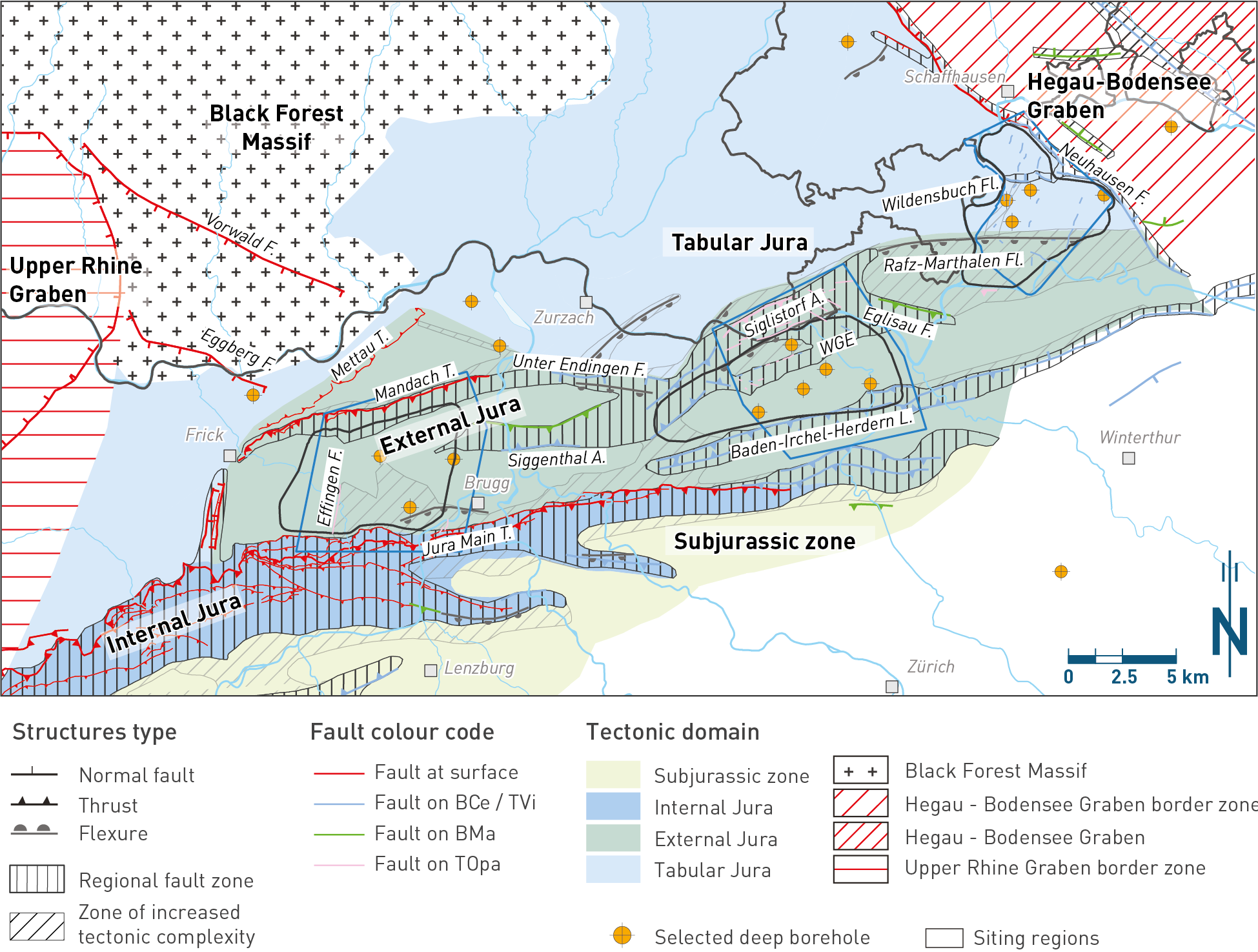
Fig. 4‑60:Tectonic map of Northern Switzerland showing regional fault zones and regional tectonic domains
This report uses historic names of tectonic structures to ensure continuity with the existing literature. Surface fault traces are based on Nagra (2014b). Fault traces from seismic interpretation are based on 2D seismic reflection (Madritsch et al. 2013, Meier et al. 2014) and 3D seismic reflection interpretation (Nagra 2024a, 2024b, 2024c). They are shown on the highest stratigraphic horizon where the specific fault segment was picked (different colours in the map view). Only horizons from Top Opalinus Clay and higher stratigraphic levels are shown. Note that only a selection of the structures from 3D seismic interpretation is shown to highlight the structural trends of regional importance. See Fig. 4‑61, Fig. 4‑65 and Fig. 4‑69 for the complete fault pattern. A.: Anticline, F.: Fault, Fl.: Flexure, L.: Lineament, T.: Thrust. WGE: Weiach – Glattfelden – Eglisau Lineament.